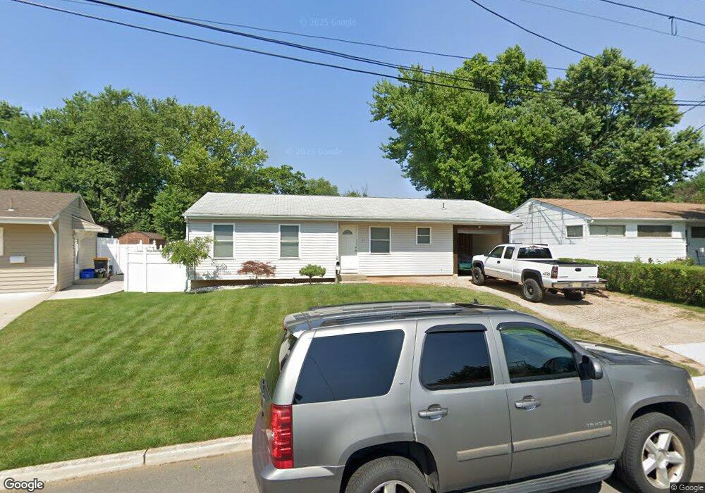
47 Purdue Rd Parlin, NJ 08859
Estimated Value: $475,000 - $505,491
3
Beds
2
Baths
1,108
Sq Ft
$439/Sq Ft
Est. Value
About This Home
This home is located at 47 Purdue Rd, Parlin, NJ 08859 and is currently estimated at $486,873, approximately $439 per square foot. 47 Purdue Rd is a home located in Middlesex County with nearby schools including Old Bridge High School and New Road School of Parlin.
Ownership History
Date
Name
Owned For
Owner Type
Purchase Details
Closed on
May 9, 2008
Sold by
Fiorino Santo
Bought by
Feeney Sean and Feeney Gina
Current Estimated Value
Home Financials for this Owner
Home Financials are based on the most recent Mortgage that was taken out on this home.
Original Mortgage
$247,000
Outstanding Balance
$156,669
Interest Rate
5.91%
Mortgage Type
Purchase Money Mortgage
Estimated Equity
$330,204
Purchase Details
Closed on
Sep 13, 2005
Sold by
Scott John
Bought by
Fiorino Santo
Home Financials for this Owner
Home Financials are based on the most recent Mortgage that was taken out on this home.
Original Mortgage
$247,500
Interest Rate
9.25%
Mortgage Type
Adjustable Rate Mortgage/ARM
Purchase Details
Closed on
Jul 28, 1999
Sold by
Kennedy Muriel
Bought by
Scott John and Scott Nancy
Home Financials for this Owner
Home Financials are based on the most recent Mortgage that was taken out on this home.
Original Mortgage
$128,221
Interest Rate
7.5%
Mortgage Type
FHA
Create a Home Valuation Report for This Property
The Home Valuation Report is an in-depth analysis detailing your home's value as well as a comparison with similar homes in the area
Home Values in the Area
Average Home Value in this Area
Purchase History
| Date | Buyer | Sale Price | Title Company |
|---|---|---|---|
| Feeney Sean | $260,000 | Shepard Title | |
| Fiorino Santo | $275,000 | -- | |
| Scott John | $132,000 | -- |
Source: Public Records
Mortgage History
| Date | Status | Borrower | Loan Amount |
|---|---|---|---|
| Open | Feeney Sean | $247,000 | |
| Previous Owner | Fiorino Santo | $247,500 | |
| Previous Owner | Scott John | $128,221 |
Source: Public Records
Tax History
| Year | Tax Paid | Tax Assessment Tax Assessment Total Assessment is a certain percentage of the fair market value that is determined by local assessors to be the total taxable value of land and additions on the property. | Land | Improvement |
|---|---|---|---|---|
| 2025 | $7,042 | $119,700 | $50,800 | $68,900 |
| 2024 | $6,773 | $119,700 | $50,800 | $68,900 |
| 2023 | $6,773 | $119,700 | $50,800 | $68,900 |
| 2022 | $6,621 | $119,700 | $50,800 | $68,900 |
| 2021 | $6,177 | $119,700 | $50,800 | $68,900 |
| 2020 | $6,417 | $119,700 | $50,800 | $68,900 |
| 2019 | $6,313 | $119,700 | $50,800 | $68,900 |
| 2018 | $6,246 | $119,700 | $50,800 | $68,900 |
| 2017 | $6,058 | $119,700 | $50,800 | $68,900 |
| 2016 | $5,944 | $119,700 | $50,800 | $68,900 |
| 2015 | $5,837 | $119,700 | $50,800 | $68,900 |
| 2014 | $5,743 | $119,700 | $50,800 | $68,900 |
Source: Public Records
Map
Nearby Homes
Your Personal Tour Guide
Ask me questions while you tour the home.