Estimated Value: $407,000 - $469,000
2
Beds
1
Bath
780
Sq Ft
$562/Sq Ft
Est. Value
About This Home
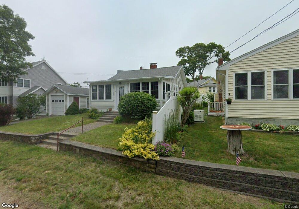
This home is located at 47 Riverside Dr, Onset, MA 02558 and is currently estimated at $438,473, approximately $562 per square foot. 47 Riverside Dr is a home.
Ownership History
Date
Name
Owned For
Owner Type
Purchase Details
Closed on
Dec 17, 2024
Sold by
Elaine J Stearns Ret and Clayton
Bought by
Clayton Michelle
Current Estimated Value
Purchase Details
Closed on
Dec 3, 2022
Sold by
Stearns Richard A and Stearns Elaine J
Bought by
Elaine J Stearns Ret and Stearns
Purchase Details
Closed on
Aug 1, 2022
Sold by
Riverside Lakeville Llc
Bought by
Berger James and Berger Diane
Purchase Details
Closed on
Dec 2, 1998
Sold by
Domaldo Abigail
Bought by
Stearns Richard A and Stearns Elaine J
Home Financials for this Owner
Home Financials are based on the most recent Mortgage that was taken out on this home.
Original Mortgage
$99,200
Interest Rate
6.68%
Mortgage Type
Purchase Money Mortgage
Create a Home Valuation Report for This Property
The Home Valuation Report is an in-depth analysis detailing your home's value as well as a comparison with similar homes in the area
Purchase History
| Date | Buyer | Sale Price | Title Company |
|---|---|---|---|
| Clayton Michelle | -- | None Available | |
| Clayton Michelle | -- | None Available | |
| Elaine J Stearns Ret | -- | None Available | |
| Elaine J Stearns Ret | -- | None Available | |
| Berger James | $395,000 | None Available | |
| Berger James | $395,000 | None Available | |
| Stearns Richard A | $124,000 | -- | |
| Stearns Richard A | $124,000 | -- |
Source: Public Records
Mortgage History
| Date | Status | Borrower | Loan Amount |
|---|---|---|---|
| Previous Owner | Stearns Richard A | $82,000 | |
| Previous Owner | Stearns Richard A | $99,200 |
Source: Public Records
Tax History
| Year | Tax Paid | Tax Assessment Tax Assessment Total Assessment is a certain percentage of the fair market value that is determined by local assessors to be the total taxable value of land and additions on the property. | Land | Improvement |
|---|---|---|---|---|
| 2025 | $4,209 | $383,300 | $173,900 | $209,400 |
| 2024 | $3,946 | $337,800 | $123,900 | $213,900 |
| 2023 | $3,619 | $307,800 | $112,700 | $195,100 |
| 2022 | $3,619 | $265,700 | $112,700 | $153,000 |
| 2021 | $3,426 | $244,700 | $112,700 | $132,000 |
| 2020 | $3,279 | $239,200 | $112,700 | $126,500 |
| 2019 | $3,077 | $226,900 | $103,800 | $123,100 |
| 2018 | $2,933 | $208,900 | $103,800 | $105,100 |
| 2017 | $2,920 | $208,900 | $103,800 | $105,100 |
| 2016 | $3,134 | $222,400 | $128,500 | $93,900 |
| 2015 | $3,017 | $220,200 | $128,500 | $91,700 |
| 2014 | $2,739 | $206,100 | $118,000 | $88,100 |
Source: Public Records
Map
Nearby Homes
- Lot 108 21st St
- 4 22nd St
- 24 Cove St
- 35 Locust St
- 35 Locust St
- 20 Evergreen St
- 10 Lydon Ln Unit A1
- 10 East Blvd
- 10 East Blvd
- 32 Carleton St Unit 32
- 29 Carleton St Unit 29
- 11 10th St
- 218 Onset Ave
- 23 Starboard Dr Unit Lot 50
- 3040 Cranberry Hwy Unit 16
- 3040 Cranberry Hwy Unit 32
- 3030 Cranberry Hwy Unit 11
- 36B Starboard Dr Unit 36E
- 36B Starboard Dr Unit 36G
- 36B Starboard Dr Unit 36C
Your Personal Tour Guide
Ask me questions while you tour the home.