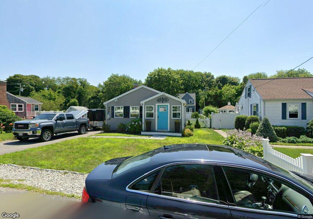
47 Towne Way Marshfield, MA 02050
Ocean Bluff-Brant Rock NeighborhoodEstimated Value: $522,000 - $597,000
3
Beds
2
Baths
1,718
Sq Ft
$325/Sq Ft
Est. Value
About This Home
This home is located at 47 Towne Way, Marshfield, MA 02050 and is currently estimated at $558,728, approximately $325 per square foot. 47 Towne Way is a home located in Plymouth County with nearby schools including Daniel Webster, Furnace Brook Middle School, and Marshfield High School.
Ownership History
Date
Name
Owned For
Owner Type
Purchase Details
Closed on
Jun 27, 2023
Sold by
Crowther Andrea K
Bought by
Crowther
Current Estimated Value
Purchase Details
Closed on
Dec 6, 2019
Sold by
Crowther Michael J and Crowther Andrea K
Bought by
Crowther Andrea K
Home Financials for this Owner
Home Financials are based on the most recent Mortgage that was taken out on this home.
Original Mortgage
$248,000
Interest Rate
3.7%
Mortgage Type
New Conventional
Purchase Details
Closed on
Mar 30, 2018
Sold by
Pomella Anthony T and Pomella Thomas
Bought by
Crowther Michael J and Crowther Andrea
Home Financials for this Owner
Home Financials are based on the most recent Mortgage that was taken out on this home.
Original Mortgage
$247,900
Interest Rate
4.38%
Mortgage Type
New Conventional
Purchase Details
Closed on
Mar 19, 2004
Sold by
Liberty Michael J and Liberty Patricia A
Bought by
Liberty Patricia A
Purchase Details
Closed on
May 30, 1995
Sold by
Damiano Nicholas R and Damiano Gerda E
Bought by
Liberty Michael J and Liberty Patricia A
Home Financials for this Owner
Home Financials are based on the most recent Mortgage that was taken out on this home.
Original Mortgage
$88,800
Interest Rate
8.33%
Mortgage Type
Purchase Money Mortgage
Create a Home Valuation Report for This Property
The Home Valuation Report is an in-depth analysis detailing your home's value as well as a comparison with similar homes in the area
Home Values in the Area
Average Home Value in this Area
Purchase History
| Date | Buyer | Sale Price | Title Company |
|---|---|---|---|
| Crowther | -- | None Available | |
| Crowther Andrea K | -- | None Available | |
| Crowther Michael J | $309,900 | -- | |
| Liberty Patricia A | -- | -- | |
| Liberty Patricia A | -- | -- | |
| Liberty Michael J | $111,000 | -- | |
| Liberty Michael J | $111,000 | -- |
Source: Public Records
Mortgage History
| Date | Status | Borrower | Loan Amount |
|---|---|---|---|
| Previous Owner | Crowther Andrea K | $248,000 | |
| Previous Owner | Crowther Michael J | $247,900 | |
| Previous Owner | Liberty Michael J | $90,000 | |
| Previous Owner | Liberty Michael J | $88,800 |
Source: Public Records
Tax History
| Year | Tax Paid | Tax Assessment Tax Assessment Total Assessment is a certain percentage of the fair market value that is determined by local assessors to be the total taxable value of land and additions on the property. | Land | Improvement |
|---|---|---|---|---|
| 2025 | $4,706 | $475,400 | $317,600 | $157,800 |
| 2024 | $4,575 | $440,300 | $297,800 | $142,500 |
| 2023 | $4,514 | $398,800 | $268,000 | $130,800 |
| 2022 | $4,384 | $338,500 | $228,300 | $110,200 |
| 2021 | $4,233 | $320,900 | $218,400 | $102,500 |
| 2020 | $3,719 | $279,000 | $188,600 | $90,400 |
| 2019 | $3,618 | $270,400 | $188,600 | $81,800 |
| 2018 | $3,584 | $268,100 | $188,600 | $79,500 |
| 2017 | $3,486 | $254,100 | $178,700 | $75,400 |
| 2016 | $3,302 | $237,900 | $168,700 | $69,200 |
| 2015 | $3,017 | $227,000 | $168,700 | $58,300 |
| 2014 | $2,980 | $224,200 | $168,700 | $55,500 |
Source: Public Records
Map
Nearby Homes