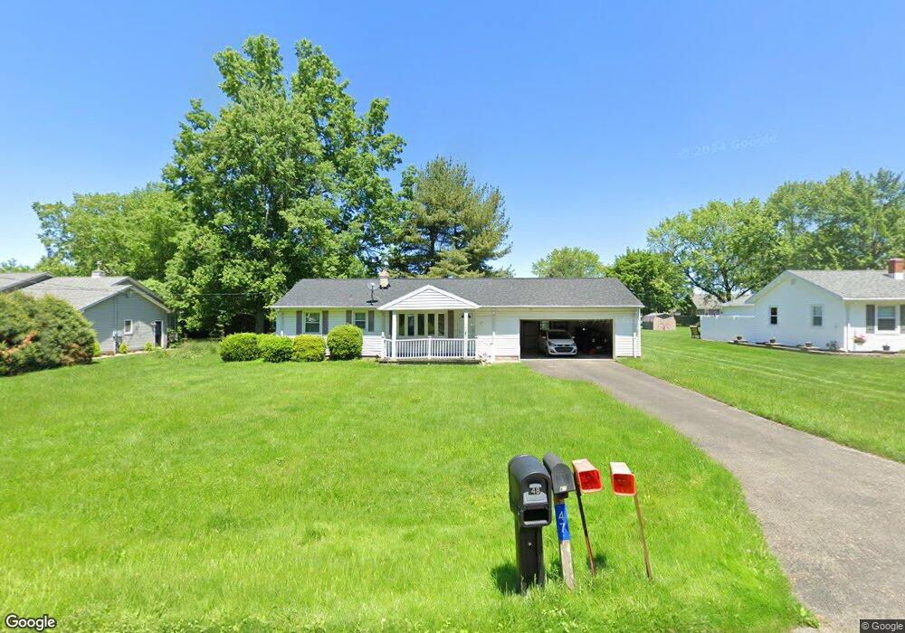
47 Ward Ave New Middletown, OH 44442
Estimated Value: $164,000 - $198,000
3
Beds
2
Baths
912
Sq Ft
$196/Sq Ft
Est. Value
About This Home
This home is located at 47 Ward Ave, New Middletown, OH 44442 and is currently estimated at $178,580, approximately $195 per square foot. 47 Ward Ave is a home located in Mahoning County with nearby schools including Springfield Elementary School, Springfield Intermediate Middle School, and Springfield High School.
Ownership History
Date
Name
Owned For
Owner Type
Purchase Details
Closed on
Jan 31, 2011
Sold by
Snyder David W
Bought by
Snyder David W and Snyder Jane A Hutchins
Current Estimated Value
Purchase Details
Closed on
Jul 12, 2001
Sold by
Martin Ann C
Bought by
Snyder David W
Purchase Details
Closed on
Dec 12, 1955
Bought by
Snyder David W and Snyder S
Create a Home Valuation Report for This Property
The Home Valuation Report is an in-depth analysis detailing your home's value as well as a comparison with similar homes in the area
Home Values in the Area
Average Home Value in this Area
Purchase History
| Date | Buyer | Sale Price | Title Company |
|---|---|---|---|
| Snyder David W | -- | Attorney | |
| Snyder David W | $110,000 | -- | |
| Snyder David W | -- | -- |
Source: Public Records
Tax History Compared to Growth
Tax History
| Year | Tax Paid | Tax Assessment Tax Assessment Total Assessment is a certain percentage of the fair market value that is determined by local assessors to be the total taxable value of land and additions on the property. | Land | Improvement |
|---|---|---|---|---|
| 2024 | $1,491 | $40,680 | $8,540 | $32,140 |
| 2023 | $1,499 | $40,680 | $8,540 | $32,140 |
| 2022 | $1,100 | $30,170 | $7,050 | $23,120 |
| 2021 | $1,056 | $30,170 | $7,050 | $23,120 |
| 2020 | $1,072 | $30,170 | $7,050 | $23,120 |
| 2019 | $1,003 | $27,330 | $7,050 | $20,280 |
| 2018 | $992 | $27,330 | $7,050 | $20,280 |
| 2017 | $978 | $27,330 | $7,050 | $20,280 |
| 2016 | $979 | $27,040 | $7,050 | $19,990 |
| 2015 | $919 | $27,040 | $7,050 | $19,990 |
| 2014 | $923 | $27,040 | $7,050 | $19,990 |
| 2013 | $910 | $27,040 | $7,050 | $19,990 |
Source: Public Records
Map
Nearby Homes
- 4940 E Calla Rd
- 56 Jeffrey Ln
- 9825 Struthers Rd
- 10115 Carrie Ct
- 10105 Carrie Ct
- 76 Stacy Dr
- 170 Sandy Ct Unit 11
- 170 Sandy Ct Unit 7
- 10250 Midway Dr
- 4035 Shelly Lynn Dr
- 4025 Shelly Lynn Dr
- 5315 Sycamore Hill Dr
- 93 Woodland Dr
- 0 E Calla Rd Unit 5175446
- 8748 Harvest Glenn Trail Unit 13
- 8736 Harvest Glenn Trail Unit 10
- 8740 Harvest Glenn Trail Unit 11
- 8744 Harvest Glenn Trail Unit 12
- 8732 Harvest Glenn Trail Unit 9
- 8741 Harvest Glenn Trail Unit 14