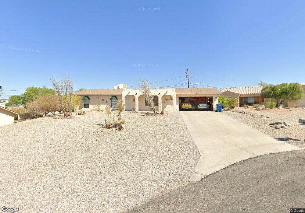
470 Mate Ln Lake Havasu City, AZ 86406
Estimated Value: $350,861 - $419,000
3
Beds
2
Baths
1,450
Sq Ft
$271/Sq Ft
Est. Value
About This Home
This home is located at 470 Mate Ln, Lake Havasu City, AZ 86406 and is currently estimated at $392,465, approximately $270 per square foot. 470 Mate Ln is a home located in Mohave County with nearby schools including Jamaica Elementary School, Thunderbolt Middle School, and Lake Havasu High School.
Ownership History
Date
Name
Owned For
Owner Type
Purchase Details
Closed on
Oct 8, 2008
Sold by
Holbert Jack D and Holbert Carole A
Bought by
Villalpando Larry M and Villalpando Laura B
Current Estimated Value
Purchase Details
Closed on
Aug 21, 2000
Sold by
Moore William K and Moore Deanna M
Bought by
Holbert Jack D and Holbert Carole A
Home Financials for this Owner
Home Financials are based on the most recent Mortgage that was taken out on this home.
Original Mortgage
$59,600
Interest Rate
8.07%
Mortgage Type
New Conventional
Create a Home Valuation Report for This Property
The Home Valuation Report is an in-depth analysis detailing your home's value as well as a comparison with similar homes in the area
Home Values in the Area
Average Home Value in this Area
Purchase History
| Date | Buyer | Sale Price | Title Company |
|---|---|---|---|
| Villalpando Larry M | $152,500 | First American Title Insuran | |
| Holbert Jack D | $74,500 | First American Title |
Source: Public Records
Mortgage History
| Date | Status | Borrower | Loan Amount |
|---|---|---|---|
| Previous Owner | Holbert Jack D | $59,600 |
Source: Public Records
Tax History Compared to Growth
Tax History
| Year | Tax Paid | Tax Assessment Tax Assessment Total Assessment is a certain percentage of the fair market value that is determined by local assessors to be the total taxable value of land and additions on the property. | Land | Improvement |
|---|---|---|---|---|
| 2026 | -- | -- | -- | -- |
| 2025 | $1,058 | $27,601 | $0 | $0 |
| 2024 | $1,058 | $29,316 | $0 | $0 |
| 2023 | $1,058 | $25,246 | $0 | $0 |
| 2022 | $1,012 | $19,904 | $0 | $0 |
| 2021 | $1,170 | $17,445 | $0 | $0 |
| 2019 | $1,114 | $13,915 | $0 | $0 |
| 2018 | $1,078 | $13,770 | $0 | $0 |
| 2017 | $1,068 | $12,233 | $0 | $0 |
| 2016 | $972 | $11,027 | $0 | $0 |
| 2015 | $934 | $8,891 | $0 | $0 |
Source: Public Records
Map
Nearby Homes
- 3485 White Cap Dr
- 3515 Thunderhawk Dr
- 3415 Saratoga Ave
- 3528 Bluegrass Dr
- 3449 Indian Peak Dr
- 3385 Saratoga Ave
- 3575 White Cap Dr
- 3500 Offshore Dr
- 3580 Whitecap Dr
- 3489 Lasser Ln
- 3330 Saddleback Dr
- 3391 Bluegrass Dr
- 3364 Thunderbird Dr
- 3329 Saddleback Dr
- 3475 Offshore Dr
- 3560 Offshore Ct
- 3431 Offshore Dr
- 3317 Saddleback Dr
- 3341 Thunderbird Dr
- 3400 Silver Saddle Dr
- 460 Mate Ln
- 3476 Thunderhawk Dr
- 480 Mate Ln
- 3478 Thunderhawk Dr
- 3474 Thunderhawk Dr
- 450 Mate Ln
- 490 Mate Ln
- 491 Mate Ln
- 471 Mate Ln
- 3472 Thunderhawk Dr
- 461 Mate Ln
- 3480 Thunderhawk Dr
- 481 Mate Ln
- 451 Mate Ln
- 3501 Thunderhawk Dr
- 3481 Whitecap Dr
- 3490 Thunderhawk Dr
- 3479 Whitecap Dr
- 3485 Whitecap Dr
- 3496 Bluegrass Dr