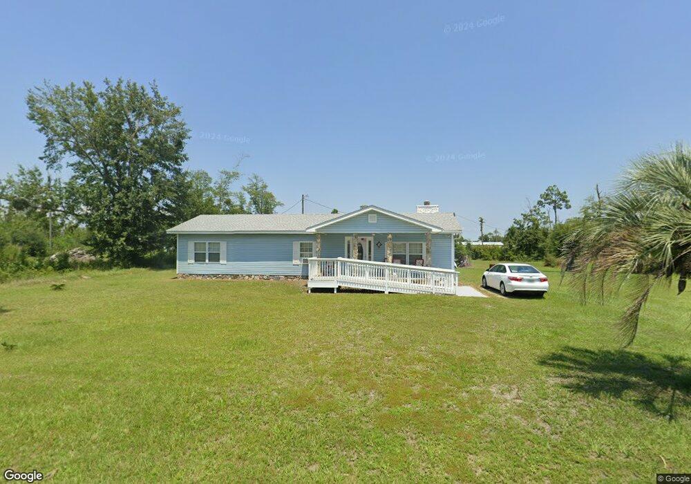
470 N Canal Dr Port Saint Joe, FL 32456
Estimated Value: $182,000 - $322,000
3
Beds
1
Bath
1,670
Sq Ft
$152/Sq Ft
Est. Value
About This Home
This home is located at 470 N Canal Dr, Port Saint Joe, FL 32456 and is currently estimated at $254,667, approximately $152 per square foot. 470 N Canal Dr is a home located in Gulf County.
Ownership History
Date
Name
Owned For
Owner Type
Purchase Details
Closed on
Sep 14, 2016
Sold by
Herring Marie S and Herring Orvil W
Bought by
Herring Mark Orvil and Herring Marie S
Current Estimated Value
Purchase Details
Closed on
Jun 8, 2000
Sold by
Bliss Myron Hans and Bliss Mary Helen
Bought by
Stewart Ramona Ann
Home Financials for this Owner
Home Financials are based on the most recent Mortgage that was taken out on this home.
Original Mortgage
$45,000
Outstanding Balance
$17,860
Interest Rate
10%
Mortgage Type
Seller Take Back
Estimated Equity
$236,807
Create a Home Valuation Report for This Property
The Home Valuation Report is an in-depth analysis detailing your home's value as well as a comparison with similar homes in the area
Home Values in the Area
Average Home Value in this Area
Purchase History
| Date | Buyer | Sale Price | Title Company |
|---|---|---|---|
| Herring Mark Orvil | -- | None Available | |
| Stewart Ramona Ann | $45,800 | -- |
Source: Public Records
Mortgage History
| Date | Status | Borrower | Loan Amount |
|---|---|---|---|
| Open | Stewart Ramona Ann | $45,000 |
Source: Public Records
Tax History Compared to Growth
Tax History
| Year | Tax Paid | Tax Assessment Tax Assessment Total Assessment is a certain percentage of the fair market value that is determined by local assessors to be the total taxable value of land and additions on the property. | Land | Improvement |
|---|---|---|---|---|
| 2024 | $47 | $37,891 | -- | -- |
| 2023 | $42 | $36,787 | $0 | $0 |
| 2022 | $65 | $35,716 | $0 | $0 |
| 2021 | $0 | $20,708 | $0 | $0 |
| 2020 | $0 | $15,984 | $0 | $0 |
| 2019 | $32 | $30,136 | $22,986 | $7,150 |
| 2018 | $72 | $35,474 | $0 | $0 |
| 2017 | $65 | $34,744 | $0 | $0 |
| 2016 | $114 | $40,466 | $0 | $0 |
| 2015 | $740 | $86,344 | $0 | $0 |
| 2014 | $689 | $85,659 | $0 | $0 |
Source: Public Records
Map
Nearby Homes
- 536 N Canal Dr
- Lot 1 Palmetto Dr
- 333 Firehouse Rd
- 7 Whippoorwill Ave
- 178 S Canal Dr
- 156 S Canal Dr
- 164 S Canal Dr
- 162 S Canal Dr Unit Lot 2- Ar
- 156 S Canal Dr Unit 1-ar
- 158 S Canal Dr Unit 2-br
- 164 S Canal Dr Unit 1-br
- 105 Chapel Ln
- 976 S Long St
- TBD S Long St
- Lot 12 Pleasant Rest Rd
- Lot 11 Pleasant Rest Rd
- 3640 Cr 386 S
- 181 Marshall Ln
- 121 Yellowfin Dr Unit Lot 5
- 137 Yellowfin Dr Unit Lot 4
- 260 N Canal Dr
- 2 N Canal Dr
- TBA N Canal Dr
- TBD N Canal Dr
- Parcel 1 N Canal Dr
- 119 Boucher Ln
- 475 N Canal Dr
- 111 Boucher Ln
- 431 N Canal Dr
- 0 N Canal Dr Unit O
- 0 N Canal Dr Unit 109893
- 0 N Canal Dr Unit 260976
- 0 N Canal Dr Unit 258094
- 0 N Canal Dr Unit 256866
- 0 N Canal Dr Unit 256037
- 0 N Canal Dr Unit 249721
- 0 N Canal Dr Unit 249166
- 0 N Canal Dr Unit 109892
- 0 N Canal Dr Unit 95072
- 0 N Canal Dr Unit 93107