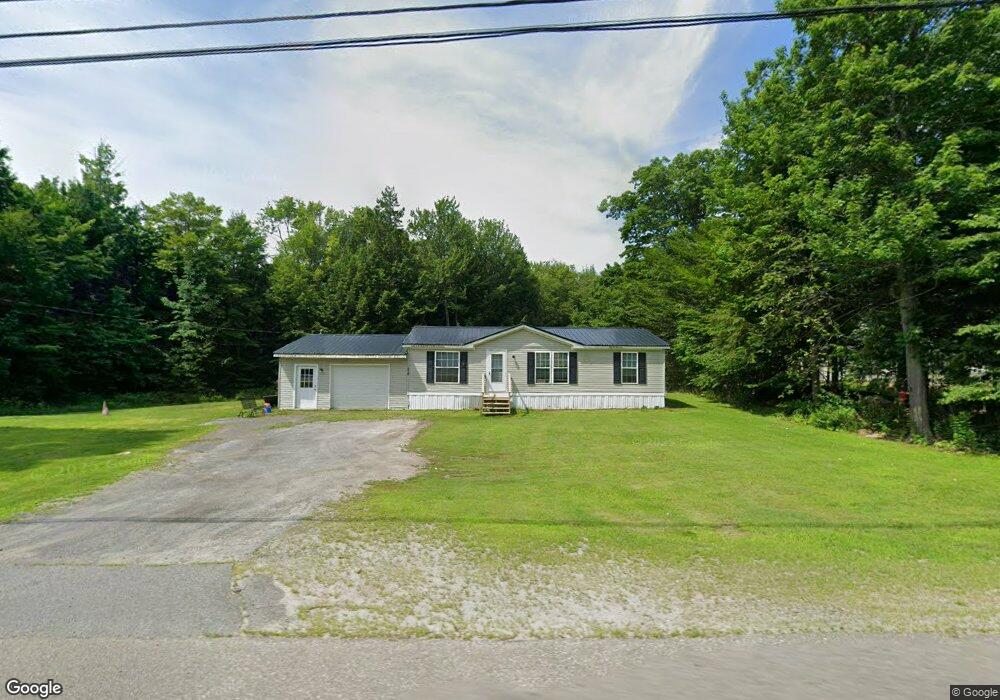
470 Smithfield Rd Oakland, ME 04963
Estimated Value: $234,391 - $353,000
3
Beds
2
Baths
1,107
Sq Ft
$277/Sq Ft
Est. Value
About This Home
This home is located at 470 Smithfield Rd, Oakland, ME 04963 and is currently estimated at $306,598, approximately $276 per square foot. 470 Smithfield Rd is a home located in Kennebec County with nearby schools including Ralph M. Atwood Primary School, China Primary School, and Williams Elementary School.
Ownership History
Date
Name
Owned For
Owner Type
Purchase Details
Closed on
Feb 3, 2012
Sold by
Breton Alan
Bought by
Dickinson James P and Dickinson Linda M
Current Estimated Value
Home Financials for this Owner
Home Financials are based on the most recent Mortgage that was taken out on this home.
Original Mortgage
$88,900
Outstanding Balance
$60,993
Interest Rate
3.92%
Mortgage Type
Commercial
Estimated Equity
$245,605
Purchase Details
Closed on
Sep 10, 2009
Sold by
Couture Monica J
Bought by
Breton Alan
Purchase Details
Closed on
Jun 24, 2005
Sold by
White Andrew K
Bought by
White Monica
Create a Home Valuation Report for This Property
The Home Valuation Report is an in-depth analysis detailing your home's value as well as a comparison with similar homes in the area
Home Values in the Area
Average Home Value in this Area
Purchase History
| Date | Buyer | Sale Price | Title Company |
|---|---|---|---|
| Dickinson James P | -- | -- | |
| Breton Alan | -- | -- | |
| White Monica | -- | -- |
Source: Public Records
Mortgage History
| Date | Status | Borrower | Loan Amount |
|---|---|---|---|
| Open | Dickinson James P | $88,900 |
Source: Public Records
Tax History Compared to Growth
Tax History
| Year | Tax Paid | Tax Assessment Tax Assessment Total Assessment is a certain percentage of the fair market value that is determined by local assessors to be the total taxable value of land and additions on the property. | Land | Improvement |
|---|---|---|---|---|
| 2024 | $1,902 | $130,100 | $36,300 | $93,800 |
| 2023 | $1,696 | $117,800 | $36,300 | $81,500 |
| 2022 | $1,737 | $101,000 | $33,000 | $68,000 |
| 2021 | $1,656 | $101,000 | $33,000 | $68,000 |
| 2020 | $1,656 | $101,000 | $33,000 | $68,000 |
| 2019 | $1,656 | $101,000 | $33,000 | $68,000 |
| 2018 | $1,656 | $101,000 | $33,000 | $68,000 |
| 2017 | $1,656 | $101,000 | $33,000 | $68,000 |
| 2016 | $1,566 | $101,000 | $33,000 | $68,000 |
| 2015 | $1,525 | $101,000 | $33,000 | $68,000 |
| 2013 | $1,394 | $101,000 | $33,000 | $68,000 |
Source: Public Records
Map
Nearby Homes
- 20 & 21 Bass Cove
- 66 Brickett Point Estates
- Lot 11 McGrath Pond Loop Rd
- 303 McGrath Pond Rd
- Lot 11 Patriots Ln
- 151 Bickford Rd
- 371 E Pond Rd
- 81 Mary Ln
- 115 Oak Hill Dr
- 78 + 98 Hussey Hill Rd
- 269 Summer St
- 30 S Gage Rd
- 31 Lake Ridge Ln Unit 31
- 32 Selden Ln
- 218 Oak St
- 5 Blueberry Ln
- 113 & 121 High St
- 0 Mutton Hill Rd Unit 1624223
- 324 Village Rd
- 91 Heath St
- 476 Smithfield Rd
- 477 Smithfield Rd
- 460 Smithfield Rd
- 489 Smithfield Rd
- 467 Smithfield Rd
- 482 Smithfield Rd
- 461 Smithfield Rd
- 435 Smithfield Rd
- 505 Smithfield Rd
- 511 Smithfield Rd
- 508 Smithfield Rd
- 422 Smithfield Rd
- 519 Smithfield Rd
- 520 Smithfield Rd
- 0 Maine 137
- 525 Smithfield Rd
- 411 Smithfield Rd
- 529 Smithfield Rd
- 528 Smithfield Rd
- 533 Smithfield Rd