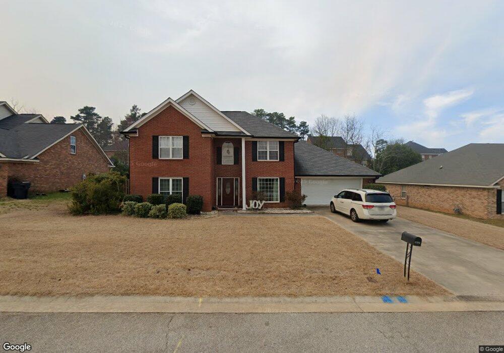
4705 Marthas Way Grovetown, GA 30813
Estimated Value: $298,000 - $306,637
4
Beds
3
Baths
2,488
Sq Ft
$121/Sq Ft
Est. Value
About This Home
This home is located at 4705 Marthas Way, Grovetown, GA 30813 and is currently estimated at $301,909, approximately $121 per square foot. 4705 Marthas Way is a home located in Columbia County with nearby schools including Grovetown Elementary School, Grovetown Middle School, and Grovetown High School.
Ownership History
Date
Name
Owned For
Owner Type
Purchase Details
Closed on
Mar 31, 2017
Sold by
Selitto Michael C
Bought by
Selitto Sylvia B
Current Estimated Value
Purchase Details
Closed on
Jul 21, 2005
Sold by
Heuman Michael D
Bought by
Selitto Michael C and Selitto Sylvia B
Home Financials for this Owner
Home Financials are based on the most recent Mortgage that was taken out on this home.
Original Mortgage
$139,740
Interest Rate
5.14%
Mortgage Type
New Conventional
Purchase Details
Closed on
May 21, 2001
Sold by
Benchmark Augusta Homes Ltd
Bought by
Heuman Michael D
Home Financials for this Owner
Home Financials are based on the most recent Mortgage that was taken out on this home.
Original Mortgage
$137,598
Interest Rate
7.02%
Mortgage Type
VA
Create a Home Valuation Report for This Property
The Home Valuation Report is an in-depth analysis detailing your home's value as well as a comparison with similar homes in the area
Home Values in the Area
Average Home Value in this Area
Purchase History
| Date | Buyer | Sale Price | Title Company |
|---|---|---|---|
| Selitto Sylvia B | -- | -- | |
| Selitto Michael C | $164,400 | -- | |
| Heuman Michael D | $134,900 | -- |
Source: Public Records
Mortgage History
| Date | Status | Borrower | Loan Amount |
|---|---|---|---|
| Previous Owner | Selitto Michael C | $139,740 | |
| Previous Owner | Heuman Michael D | $137,598 |
Source: Public Records
Tax History Compared to Growth
Tax History
| Year | Tax Paid | Tax Assessment Tax Assessment Total Assessment is a certain percentage of the fair market value that is determined by local assessors to be the total taxable value of land and additions on the property. | Land | Improvement |
|---|---|---|---|---|
| 2025 | $3,005 | $108,798 | $4,904 | $103,894 |
| 2024 | $3,223 | $110,737 | $4,184 | $106,553 |
| 2023 | $3,223 | $93,226 | $4,064 | $89,162 |
| 2022 | $2,600 | $85,862 | $4,164 | $81,698 |
| 2021 | $2,352 | $74,559 | $3,844 | $70,715 |
| 2020 | $2,348 | $73,154 | $3,464 | $69,690 |
| 2019 | $2,121 | $65,605 | $3,284 | $62,321 |
| 2018 | $2,292 | $69,678 | $3,164 | $66,514 |
| 2017 | $2,198 | $67,434 | $3,204 | $64,230 |
| 2016 | $2,018 | $63,561 | $2,980 | $60,581 |
| 2015 | $1,965 | $61,579 | $2,860 | $58,719 |
| 2014 | $1,842 | $57,131 | $2,780 | $54,351 |
Source: Public Records
Map
Nearby Homes
- 636 Butler Springs Cir
- 4907 Selkirk Way
- 824 Shirez Dr
- 1100 Durban Dr
- 427 Roebuck Pass
- 4917 Cavan Place
- 0 E Robinson Ave
- 132 Summerfield Cir
- 3052 Pepperhill Dr
- 5056 Captain Dr
- 100 Buck Ave
- 125 Redford Dr
- 1399 Admiral Ave
- 1352 Admiral Ave
- 1392 Admiral Ave
- 1384 Admiral Ave Unit 117
- 1348 Admiral Ave
- 1380 Admiral Ave Unit 116
- 1388 Admiral Ave
- 1344 Admiral Ave
- 4703 Marthas Way
- 4707 Marthas Way
- 4009 Nantucket Cir
- 4101 Nantucket Cir
- 4007 Nantucket Cir
- 4709 Marthas Way
- 4701 Martha's Way
- 4706 Marthas Way
- 4704 Marthas Way
- 4708 Marthas Way
- 4005 Nantucket Cir
- 4103 Nantucket Cir
- 4702 Marthas Way
- 4710 Marthas Way
- 4711 Marthas Way
- 4712 Martha's Way
- 4003 Nantucket Cir
- 4014 Nantucket Cir
- 3921 Nantucket Cir
- 4700 Marthas Way