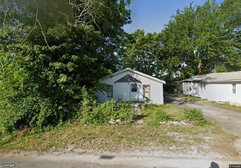
4708 Pearl Ave East Saint Louis, IL 62207
Estimated Value: $40,000 - $81,000
--
Bed
--
Bath
860
Sq Ft
$66/Sq Ft
Est. Value
About This Home
This home is located at 4708 Pearl Ave, East Saint Louis, IL 62207 and is currently estimated at $56,764, approximately $66 per square foot. 4708 Pearl Ave is a home located in St. Clair County with nearby schools including Katie Harper-Wright Elementary School, Mason/Clark Middle School, and East St Louis Senior High School.
Ownership History
Date
Name
Owned For
Owner Type
Purchase Details
Closed on
Dec 18, 2024
Sold by
Muhammad Ralph
Bought by
East Saint Enterprise Llc
Current Estimated Value
Purchase Details
Closed on
Dec 22, 2015
Sold by
Collins Charles and Covington Delores
Bought by
Muhammad Ralph
Purchase Details
Closed on
May 26, 2006
Sold by
Collins Charles
Bought by
Collins Charles and Covington Delores
Create a Home Valuation Report for This Property
The Home Valuation Report is an in-depth analysis detailing your home's value as well as a comparison with similar homes in the area
Home Values in the Area
Average Home Value in this Area
Purchase History
| Date | Buyer | Sale Price | Title Company |
|---|---|---|---|
| East Saint Enterprise Llc | $7,500 | Accent Title | |
| Muhammad Ralph | -- | None Available | |
| Collins Charles | -- | None Available |
Source: Public Records
Tax History Compared to Growth
Tax History
| Year | Tax Paid | Tax Assessment Tax Assessment Total Assessment is a certain percentage of the fair market value that is determined by local assessors to be the total taxable value of land and additions on the property. | Land | Improvement |
|---|---|---|---|---|
| 2024 | $1,010 | $17,300 | $689 | $16,611 |
| 2023 | $762 | $15,637 | $623 | $15,014 |
| 2022 | $473 | $13,705 | $546 | $13,159 |
| 2021 | $365 | $12,986 | $517 | $12,469 |
| 2020 | $0 | $10,397 | $541 | $9,856 |
| 2019 | $0 | $10,397 | $541 | $9,856 |
| 2018 | $0 | $10,549 | $549 | $10,000 |
| 2017 | $0 | $10,295 | $536 | $9,759 |
| 2016 | $0 | $8,232 | $534 | $7,698 |
| 2014 | -- | $8,142 | $528 | $7,614 |
| 2013 | -- | $7,637 | $495 | $7,142 |
Source: Public Records
Map
Nearby Homes
- 604 West Ave
- 6330 Church Rd
- 5413 Nelson Ave
- 1927 Bond Ave
- 3325 Bond Ave
- 3300 Mccasland Ave
- 2953 Virginia Place
- 2372 Lorraine Dr
- 2626 Missouri Ave
- 2274 Carol St
- 2416 Lorraine Dr
- 3125 Louisiana Blvd
- 1997 Oak Tree Ln
- 351 N 26th St
- 28 Louise Ln
- 34 Marilyn Ln
- 2014 Florence St
- 506 N 51st St
- 512 N 50th St
- 22 Marilyn Ln
- 4642 Trendley Ave
- 4638 Trendley Ave
- 4636 Trendley Ave
- 4331 Piggott Ave
- 728 S 47th St
- 724 S 47th St
- 4337 Piggott Ave
- 4345 Tudor Ave
- 4633 Tudor Ave
- 4629 Tudor Ave
- 4331 Trendley Ave
- 4348 Tudor Ave
- 4315 Piggott Ave
- 424 S 45th St
- 4323 Tudor Ave
- 4310 Trendley Ave
- 4900 Pearl Ave
- 408 S 44th St
- 418 S 45th St
- 4311 Trendley Ave