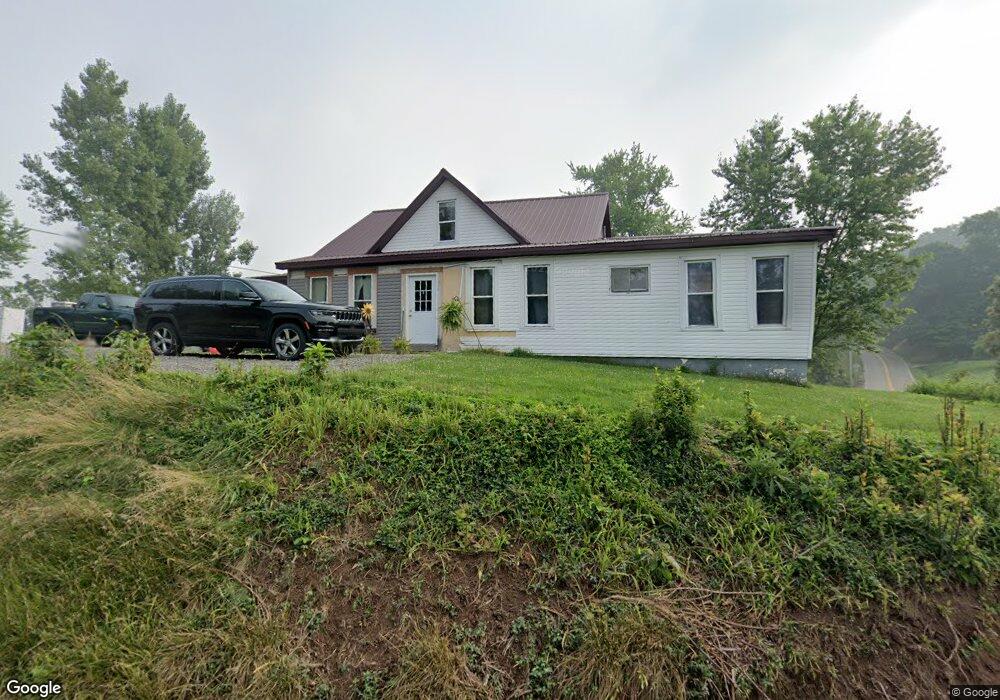
47084 State Route 536 Clarington, OH 43915
Estimated Value: $217,000 - $240,000
4
Beds
2
Baths
1,480
Sq Ft
$152/Sq Ft
Est. Value
About This Home
This home is located at 47084 State Route 536, Clarington, OH 43915 and is currently estimated at $225,333, approximately $152 per square foot. 47084 State Route 536 is a home located in Monroe County with nearby schools including River Elementary School and River High School.
Ownership History
Date
Name
Owned For
Owner Type
Purchase Details
Closed on
Nov 21, 2025
Sold by
Anderson David M
Bought by
Anderson David M and Anderson Alison
Current Estimated Value
Purchase Details
Closed on
May 10, 2023
Sold by
Anderson Cari A
Bought by
Anderson David M
Purchase Details
Closed on
Jul 3, 2003
Bought by
Anderson David M and Anderson Cari A
Purchase Details
Closed on
Oct 12, 2000
Bought by
Anderson David M and Anderson Cari A
Create a Home Valuation Report for This Property
The Home Valuation Report is an in-depth analysis detailing your home's value as well as a comparison with similar homes in the area
Home Values in the Area
Average Home Value in this Area
Purchase History
| Date | Buyer | Sale Price | Title Company |
|---|---|---|---|
| Anderson David M | -- | None Listed On Document | |
| Anderson David M | -- | None Listed On Document | |
| Anderson David M | $48,000 | -- | |
| Anderson David M | $34,500 | -- |
Source: Public Records
Tax History Compared to Growth
Tax History
| Year | Tax Paid | Tax Assessment Tax Assessment Total Assessment is a certain percentage of the fair market value that is determined by local assessors to be the total taxable value of land and additions on the property. | Land | Improvement |
|---|---|---|---|---|
| 2024 | $120 | $4,040 | $4,040 | $0 |
| 2023 | $120 | $4,040 | $4,040 | $0 |
| 2022 | $120 | $4,040 | $4,040 | $0 |
| 2021 | $99 | $3,310 | $3,310 | $0 |
| 2020 | $99 | $3,310 | $3,310 | $0 |
| 2019 | $100 | $3,350 | $3,350 | $0 |
| 2018 | $87 | $2,790 | $2,790 | $0 |
| 2017 | $87 | $2,790 | $2,790 | $0 |
| 2016 | $88 | $2,790 | $2,790 | $0 |
| 2015 | $119 | $3,590 | $2,630 | $960 |
| 2014 | $117 | $3,590 | $2,630 | $960 |
| 2013 | $123 | $3,480 | $2,550 | $930 |
Source: Public Records
Map
Nearby Homes
- 44883 Bondi Ridge Rd
- 111 Main St
- 49100 Township Road 198
- 448 Market St
- 0 Lickskillet Rd
- 618 Market St
- 50504 State Route 556
- 0 Township Rd 460 Unit 23727141
- Township Road 460
- 52736 Fisher Hill Rd
- 48375 Benwood Rd
- 48457 Ohio 556
- 147 Andover Rd
- 74 Anson St
- 1239 Wren Dr
- 39567 State Route 800
- 123 Andover Rd
- 314 Devon Rd
- 46 Orchard Dr
- 826 Meadow Dr
- 47084 State Route 536
- 47091 State Route 536
- 47033 State Route 536
- 46752 State Route 536
- 47175 State Route 536
- 46752 Ohio 536
- 44699 Township Road 369
- 47091 Ohio 536
- 46711 State Route 536
- 44635 Township Road 369
- 47266 State Route 536
- 47221 State Route 536
- 47433 Sykes Ridge Rd
- 45095 Winkler Rd
- 46689 State Route 536
- 47267 State Route 536
- 46655 State Route 536
- 44963 Green Hill Rd
- 44963 Green Hill Rd
- 46390 State Route 536