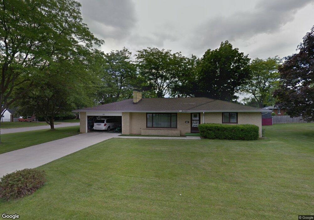
471 Clearview Rd Mansfield, OH 44907
Estimated Value: $180,000 - $235,000
3
Beds
2
Baths
1,696
Sq Ft
$124/Sq Ft
Est. Value
About This Home
This home is located at 471 Clearview Rd, Mansfield, OH 44907 and is currently estimated at $210,392, approximately $124 per square foot. 471 Clearview Rd is a home located in Richland County with nearby schools including Mansfield Christian School, Discovery School, and Mansfield Seventh-day Adventist School.
Ownership History
Date
Name
Owned For
Owner Type
Purchase Details
Closed on
May 10, 2024
Bought by
Mckee Bryce S
Current Estimated Value
Home Financials for this Owner
Home Financials are based on the most recent Mortgage that was taken out on this home.
Original Mortgage
$83,000
Outstanding Balance
$81,503
Interest Rate
6.79%
Mortgage Type
New Conventional
Estimated Equity
$128,889
Purchase Details
Closed on
Nov 21, 2017
Sold by
Donathan Judith L
Bought by
Mckee Mark S and Donathan Irrevocable Judith L
Purchase Details
Closed on
Aug 23, 2017
Sold by
Race Larry G
Bought by
Donathan Judith L
Purchase Details
Closed on
Aug 19, 1992
Sold by
Race Michael W
Bought by
Race Michael W
Create a Home Valuation Report for This Property
The Home Valuation Report is an in-depth analysis detailing your home's value as well as a comparison with similar homes in the area
Home Values in the Area
Average Home Value in this Area
Purchase History
| Date | Buyer | Sale Price | Title Company |
|---|---|---|---|
| Mckee Bryce S | $160,000 | None Listed On Document | |
| Mckee Bryce S | $160,000 | None Listed On Document | |
| Mckee Mark S | $50,000 | None Available | |
| Donathan Judith L | -- | Attorney | |
| Race Michael W | -- | -- |
Source: Public Records
Mortgage History
| Date | Status | Borrower | Loan Amount |
|---|---|---|---|
| Open | Mckee Bryce S | $83,000 | |
| Closed | Mckee Bryce S | $83,000 |
Source: Public Records
Tax History
| Year | Tax Paid | Tax Assessment Tax Assessment Total Assessment is a certain percentage of the fair market value that is determined by local assessors to be the total taxable value of land and additions on the property. | Land | Improvement |
|---|---|---|---|---|
| 2024 | $2,400 | $52,420 | $9,050 | $43,370 |
| 2023 | $2,454 | $52,420 | $9,050 | $43,370 |
| 2022 | $2,010 | $35,980 | $7,190 | $28,790 |
| 2021 | $2,024 | $35,980 | $7,190 | $28,790 |
| 2020 | $2,070 | $35,980 | $7,190 | $28,790 |
| 2019 | $1,944 | $30,490 | $6,090 | $24,400 |
| 2018 | $1,367 | $30,490 | $6,090 | $24,400 |
| 2017 | $1,685 | $30,490 | $6,090 | $24,400 |
| 2016 | $2,039 | $41,060 | $7,840 | $33,220 |
| 2015 | $2,039 | $41,060 | $7,840 | $33,220 |
| 2014 | $1,922 | $41,060 | $7,840 | $33,220 |
| 2012 | $781 | $43,220 | $8,250 | $34,970 |
Source: Public Records
Map
Nearby Homes
- 0 Lexington Ave Unit 224009661
- 489 Clifton Blvd
- 1179 Burkwood Rd
- 1327 S Trimble Rd
- 1702 Middle Bellville Rd
- 1066 Burkwood Rd
- 735 Courtwright Blvd
- 0 Rippling Brook Dr
- 755 Locust Ln
- 893 Greenfield Dr
- 601 Karlson Dr
- 635 Karlson Dr
- 1521 Cape Cod Dr
- 615 Bailey Dr
- 986 Woodland Rd
- 400 James Ave
- 1510 Cape Cod Dr Unit 1504
- 810 Lexington Ave
- 0 George Ave
- 763 York St W
- 1338 Sharon Rd
- 1327 Sharon Rd
- 1327 Paul Blvd
- 458 Clearview Rd
- 1337 Sharon Rd
- 1337 Paul Blvd
- 448 Clearview Rd
- 1348 Sharon Rd
- 1328 Tiffany Dr
- 1347 Sharon Rd
- 1338 Tiffany Dr
- 440 Clearview Rd
- 1357 Sharon Rd
- 451 Birchlawn Blvd
- 1358 Sharon Rd
- 465 Birchlawn Blvd
- 1340 Paul Blvd
- 1348 Tiffany Dr
- 443 Birchlawn Blvd
- 432 Clearview Rd
Your Personal Tour Guide
Ask me questions while you tour the home.