Estimated Value: $261,000 - $289,000
3
Beds
1
Bath
960
Sq Ft
$285/Sq Ft
Est. Value
About This Home
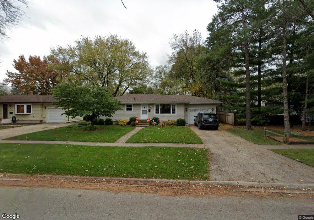
This home is located at 471 Lloyd St, Cary, IL 60013 and is currently estimated at $273,756, approximately $285 per square foot. 471 Lloyd St is a home located in McHenry County with nearby schools including Three Oaks Elementary School, Cary Jr High School, and Cary Grove High School.
Ownership History
Date
Name
Owned For
Owner Type
Purchase Details
Closed on
Aug 11, 2008
Sold by
Demeo Margaret F
Bought by
Dodge William and Dodge Dawn Amberly
Current Estimated Value
Home Financials for this Owner
Home Financials are based on the most recent Mortgage that was taken out on this home.
Original Mortgage
$151,200
Outstanding Balance
$100,831
Interest Rate
6.66%
Mortgage Type
Unknown
Estimated Equity
$172,925
Purchase Details
Closed on
Dec 13, 2001
Sold by
Demeo Margaret F
Bought by
Demeo Margaret F
Purchase Details
Closed on
Apr 17, 1998
Sold by
Buchhop Peter K and Buchhop Joanne M
Bought by
Demeo Raymond F and Demeo Margaret F
Create a Home Valuation Report for This Property
The Home Valuation Report is an in-depth analysis detailing your home's value as well as a comparison with similar homes in the area
Home Values in the Area
Average Home Value in this Area
Purchase History
| Date | Buyer | Sale Price | Title Company |
|---|---|---|---|
| Dodge William | $168,000 | Lawyers Title | |
| Demeo Margaret F | -- | -- | |
| Demeo Raymond F | $127,000 | Universal Title Services Inc |
Source: Public Records
Mortgage History
| Date | Status | Borrower | Loan Amount |
|---|---|---|---|
| Open | Dodge William | $151,200 |
Source: Public Records
Tax History Compared to Growth
Tax History
| Year | Tax Paid | Tax Assessment Tax Assessment Total Assessment is a certain percentage of the fair market value that is determined by local assessors to be the total taxable value of land and additions on the property. | Land | Improvement |
|---|---|---|---|---|
| 2024 | $5,350 | $71,527 | $16,835 | $54,692 |
| 2023 | $5,181 | $63,972 | $15,057 | $48,915 |
| 2022 | $4,576 | $54,873 | $16,863 | $38,010 |
| 2021 | $4,342 | $51,121 | $15,710 | $35,411 |
| 2020 | $4,202 | $49,311 | $15,154 | $34,157 |
| 2019 | $4,106 | $47,196 | $14,504 | $32,692 |
| 2018 | $3,847 | $43,599 | $13,399 | $30,200 |
| 2017 | $3,753 | $41,073 | $12,623 | $28,450 |
| 2016 | $3,703 | $38,523 | $11,839 | $26,684 |
| 2013 | -- | $41,190 | $11,044 | $30,146 |
Source: Public Records
Map
Nearby Homes
- 340 W Margaret Terrace
- 336 W Margaret Terrace
- 120 Bright Oaks Cir
- 411 Park Ave
- 324 Alma Terrace
- 16 Forest Ln
- 60 Bright Oaks Cir Unit 1
- 550 Norman Dr
- 20 Oak Valley Dr Unit 2
- 589 Arthur Dr
- Lots 2,3,4 Northwest Hwy
- 368 Copper Canyon Trail
- 26 Wagner Dr
- 641 Alida Dr
- 1129 Amber Dr
- 1200 W Lake Dr
- 50 Erin Dr
- 20 Willow Cir
- 1173 Amber Dr
- 2 Daybreak Ridge Trail
- 463 Lloyd St
- 483 Lloyd St
- 457 Lloyd St
- 472 W Margaret Terrace
- 466 W Margaret Terrace
- 476 W Margaret Terrace
- 460 W Margaret Terrace
- 472 Lloyd St
- 805 Silver Lake Rd
- 451 Lloyd St
- 905 Silver Lake Rd
- 466 Lloyd St
- 452 W Margaret Terrace
- 460 Lloyd St
- 445 Lloyd St
- 452 Lloyd St
- 446 W Margaret Terrace
- 471 W Margaret Terrace
- 439 Lloyd St
- 446 Lloyd St