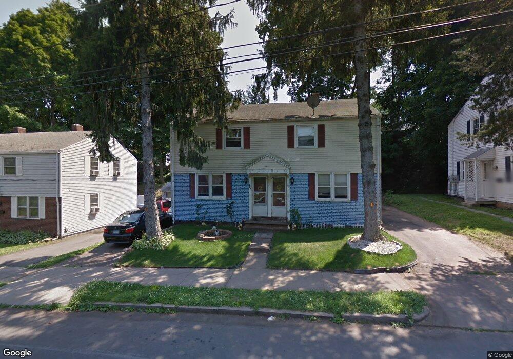
472 Black Rock Ave New Britain, CT 06052
Estimated Value: $253,000 - $398,000
4
Beds
2
Baths
1,776
Sq Ft
$176/Sq Ft
Est. Value
About This Home
This home is located at 472 Black Rock Ave, New Britain, CT 06052 and is currently estimated at $313,351, approximately $176 per square foot. 472 Black Rock Ave is a home located in Hartford County with nearby schools including Lincoln School, Slade Middle School, and Mountain Laurel Sudbury School.
Ownership History
Date
Name
Owned For
Owner Type
Purchase Details
Closed on
Mar 5, 2010
Sold by
Keopraseuth Cia
Bought by
Keopraseuth Mam
Current Estimated Value
Purchase Details
Closed on
Jan 9, 2001
Sold by
Dyson Howard and Dyson Julie B
Bought by
Keopraseuth Cia
Home Financials for this Owner
Home Financials are based on the most recent Mortgage that was taken out on this home.
Original Mortgage
$52,800
Interest Rate
7.69%
Create a Home Valuation Report for This Property
The Home Valuation Report is an in-depth analysis detailing your home's value as well as a comparison with similar homes in the area
Home Values in the Area
Average Home Value in this Area
Purchase History
| Date | Buyer | Sale Price | Title Company |
|---|---|---|---|
| Keopraseuth Mam | -- | -- | |
| Keopraseuth Cia | $70,000 | -- |
Source: Public Records
Mortgage History
| Date | Status | Borrower | Loan Amount |
|---|---|---|---|
| Previous Owner | Keopraseuth Cia | $71,000 | |
| Previous Owner | Keopraseuth Cia | $73,000 | |
| Previous Owner | Keopraseuth Cia | $52,800 |
Source: Public Records
Tax History Compared to Growth
Tax History
| Year | Tax Paid | Tax Assessment Tax Assessment Total Assessment is a certain percentage of the fair market value that is determined by local assessors to be the total taxable value of land and additions on the property. | Land | Improvement |
|---|---|---|---|---|
| 2025 | $5,444 | $138,950 | $36,890 | $102,060 |
| 2024 | $5,501 | $138,950 | $36,890 | $102,060 |
| 2023 | $5,319 | $138,950 | $36,890 | $102,060 |
| 2022 | $4,501 | $90,930 | $17,010 | $73,920 |
| 2021 | $4,501 | $90,930 | $17,010 | $73,920 |
| 2020 | $4,592 | $90,930 | $17,010 | $73,920 |
| 2019 | $4,592 | $90,930 | $17,010 | $73,920 |
| 2018 | $4,592 | $90,930 | $17,010 | $73,920 |
| 2017 | $3,942 | $78,050 | $17,290 | $60,760 |
| 2016 | $3,942 | $78,050 | $17,290 | $60,760 |
| 2015 | $3,824 | $78,050 | $17,290 | $60,760 |
| 2014 | $3,824 | $78,050 | $17,290 | $60,760 |
Source: Public Records
Map
Nearby Homes
- 149 Pennsylvania Ave Unit 151
- 817 W Main St
- 33 Colt St
- 236 Garry Dr
- 78 May St
- 84 May St
- 30 Westerly St
- 43 Westerly St
- 80 N Mountain Rd Unit B
- 65 Torkom Dr
- 42 Fairlane Dr
- 28 Weigands Dr
- 112 Lincoln St
- 66 Lincoln St
- 145 Reservoir Rd
- 1467 Corbin Ave
- 300 Lincoln St
- 423 Monroe St
- 367 Lincoln St
- 151 Sterling St
- 466 Black Rock Ave Unit 468
- 480 Black Rock Ave
- 121 Pennsylvania Ave
- 127 Pennsylvania Ave
- 127 Pennsylvania Ave Unit 129
- 458 Black Rock Ave
- 135 Pennsylvania Ave
- 131 Pennsylvania Ave Unit 127
- 488 Black Rock Ave
- 115 Pennsylvania Ave
- 129 Pennsylvania Ave
- 141 Pennsylvania Ave
- 450 Black Rock Ave
- 494 Black Rock Ave
- 107 Pennsylvania Ave Unit 109
- 124 Pennsylvania Ave
- 130 Pennsylvania Ave
- 122 Pennsylvania Ave
- 136 Pennsylvania Ave
- 442 Black Rock Ave