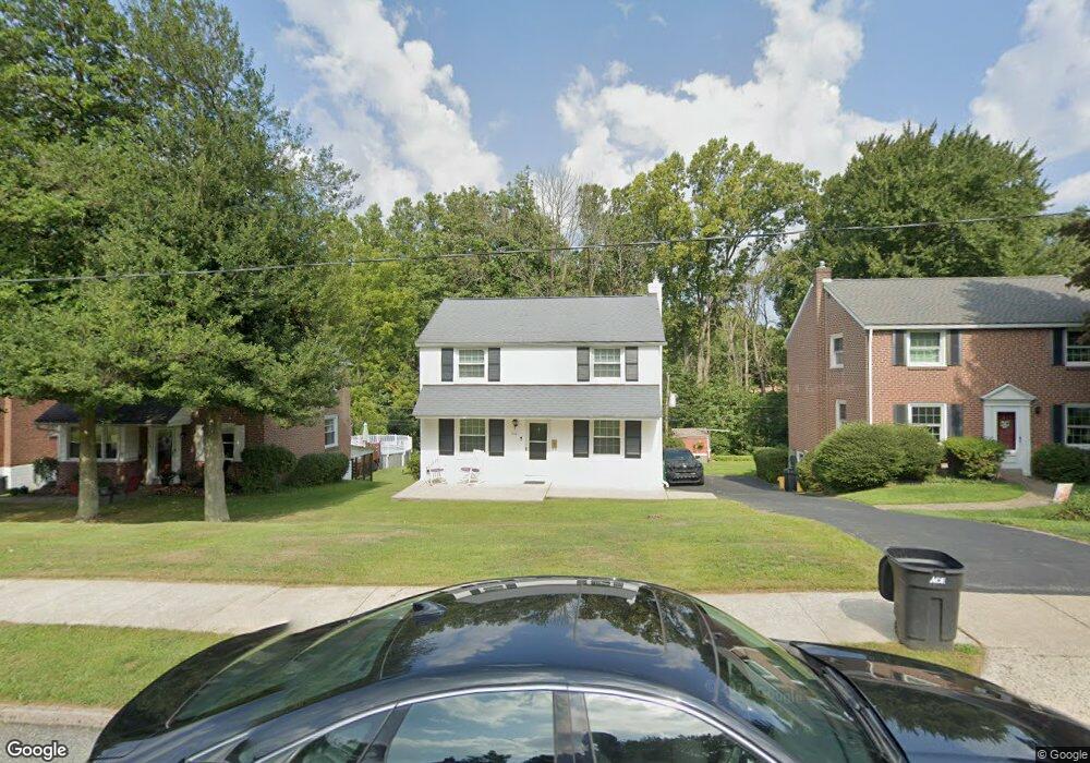
472 Briarhill Rd Springfield, PA 19064
Estimated Value: $396,000 - $438,603
3
Beds
1
Bath
1,416
Sq Ft
$296/Sq Ft
Est. Value
About This Home
This home is located at 472 Briarhill Rd, Springfield, PA 19064 and is currently estimated at $419,651, approximately $296 per square foot. 472 Briarhill Rd is a home located in Delaware County with nearby schools including Springfield High School, St Francis Of Assisi School, and Holy Cross School.
Ownership History
Date
Name
Owned For
Owner Type
Purchase Details
Closed on
Jan 27, 1995
Sold by
Diluzio Theresa F
Bought by
Rooney Christopher C and Manning Eileen P
Current Estimated Value
Home Financials for this Owner
Home Financials are based on the most recent Mortgage that was taken out on this home.
Original Mortgage
$102,800
Interest Rate
8.96%
Purchase Details
Closed on
Jan 23, 1995
Sold by
Diluzio Robert M and Diluzio Theresa F
Bought by
Diluzio Theresa F
Home Financials for this Owner
Home Financials are based on the most recent Mortgage that was taken out on this home.
Original Mortgage
$102,800
Interest Rate
8.96%
Create a Home Valuation Report for This Property
The Home Valuation Report is an in-depth analysis detailing your home's value as well as a comparison with similar homes in the area
Home Values in the Area
Average Home Value in this Area
Purchase History
| Date | Buyer | Sale Price | Title Company |
|---|---|---|---|
| Rooney Christopher C | $128,500 | -- | |
| Diluzio Theresa F | -- | -- |
Source: Public Records
Mortgage History
| Date | Status | Borrower | Loan Amount |
|---|---|---|---|
| Closed | Rooney Christopher C | $102,800 |
Source: Public Records
Tax History
| Year | Tax Paid | Tax Assessment Tax Assessment Total Assessment is a certain percentage of the fair market value that is determined by local assessors to be the total taxable value of land and additions on the property. | Land | Improvement |
|---|---|---|---|---|
| 2025 | $7,575 | $269,490 | $96,110 | $173,380 |
| 2024 | $7,575 | $269,490 | $96,110 | $173,380 |
| 2023 | $7,294 | $269,490 | $96,110 | $173,380 |
| 2022 | $7,136 | $269,490 | $96,110 | $173,380 |
| 2021 | $11,051 | $269,490 | $96,110 | $173,380 |
| 2020 | $5,470 | $120,720 | $46,200 | $74,520 |
| 2019 | $5,342 | $120,720 | $46,200 | $74,520 |
| 2018 | $5,265 | $120,720 | $0 | $0 |
| 2017 | $5,144 | $120,720 | $0 | $0 |
| 2016 | $663 | $120,720 | $0 | $0 |
| 2015 | $676 | $120,720 | $0 | $0 |
| 2014 | $676 | $120,720 | $0 | $0 |
Source: Public Records
Map
Nearby Homes
- 493 Wheatsheaf Rd
- 364 S Rolling Rd
- 31 Wayfield Rd
- 227 E Leamy Ave
- 1299 Country Club Dr Unit Q141
- 1291 Country Club Dr Unit Q137
- 1433 Country Club Dr Unit T214
- 332 Franklin Ave
- 111 Forest Rd
- 147 Snyder Ln
- 226 Lynbrooke Rd
- 1588 Nicklaus Dr Unit H65
- 933 Greenbriar Ln
- 641 W Sproul Rd
- 114 Providence Rd
- 519 Walnut Ln Unit 1
- 120 W Springfield Rd
- 606 W Springfield Rd
- 978 Westfield Rd
- 516 Beatty Rd
- 476 Briarhill Rd
- 468 Briarhill Rd
- 464 Briarhill Rd
- 480 Briarhill Rd
- 484 Briarhill Rd
- 460 Briarhill Rd
- 471 Briarhill Rd
- 454 Briarhill Rd
- 488 Briarhill Rd
- 465 Briarhill Rd
- 475 Briarhill Rd
- 461 Briarhill Rd
- 481 Briarhill Rd
- 492 Briarhill Rd
- 450 Briarhill Rd
- 455 Briarhill Rd
- 485 Briarhill Rd
- 451 Briarhill Rd
- 494 Briarhill Rd
Your Personal Tour Guide
Ask me questions while you tour the home.