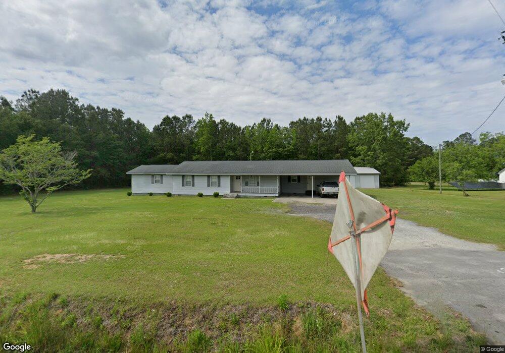
472 Highway 548 Conway, SC 29527
Estimated Value: $295,000 - $371,000
3
Beds
2
Baths
2,208
Sq Ft
$157/Sq Ft
Est. Value
About This Home
This home is located at 472 Highway 548, Conway, SC 29527 and is currently estimated at $346,144, approximately $156 per square foot. 472 Highway 548 is a home located in Horry County with nearby schools including Conway Elementary School, Conway Middle School, and Conway High School.
Ownership History
Date
Name
Owned For
Owner Type
Purchase Details
Closed on
May 13, 2005
Sold by
Lilly Eric D and Lilly Lisa S
Bought by
Lilly Evelyn H
Current Estimated Value
Purchase Details
Closed on
May 12, 2005
Sold by
Lilly Evelyn H and Estate Of Larry David Lilly
Bought by
Lilly Evelyn H and Lilly Eric D
Create a Home Valuation Report for This Property
The Home Valuation Report is an in-depth analysis detailing your home's value as well as a comparison with similar homes in the area
Home Values in the Area
Average Home Value in this Area
Purchase History
| Date | Buyer | Sale Price | Title Company |
|---|---|---|---|
| Lilly Evelyn H | -- | -- | |
| Lilly Evelyn H | -- | -- |
Source: Public Records
Tax History Compared to Growth
Tax History
| Year | Tax Paid | Tax Assessment Tax Assessment Total Assessment is a certain percentage of the fair market value that is determined by local assessors to be the total taxable value of land and additions on the property. | Land | Improvement |
|---|---|---|---|---|
| 2024 | $581 | $17,660 | $4,050 | $13,610 |
| 2023 | $519 | $6,441 | $942 | $5,499 |
| 2021 | $504 | $10,792 | $1,750 | $9,042 |
| 2020 | $425 | $10,792 | $1,750 | $9,042 |
| 2019 | $425 | $10,792 | $1,750 | $9,042 |
| 2018 | $361 | $8,401 | $1,027 | $7,374 |
| 2017 | $346 | $5,600 | $684 | $4,916 |
| 2016 | -- | $5,600 | $684 | $4,916 |
| 2015 | $346 | $5,601 | $685 | $4,916 |
| 2014 | $320 | $5,601 | $685 | $4,916 |
Source: Public Records
Map
Nearby Homes
- 197 Springtide Dr
- 635 State Highway 548
- 631 State Highway 548
- 600 Shallow Cove Dr Unit Lot 154
- 594 Shallow Cove Dr Unit Lot 151
- 598 Shallow Cove Dr Unit Lot 153
- 596 Shallow Cove Dr Unit Lot 152
- 284 Palmetto Sand Loop Unit Lot 21 Barnard II
- 220 Palmetto Sand Loop Unit Lot 36 Odessa II
- 236 Palmetto Sand Loop Unit Lot 32 Odessa II
- 288 Palmetto Sand Loop Unit Lot 20 Darcy II
- 280 Palmetto Sand Loop Unit Lot 22 Odessa II
- Bailey II Plan at Beach Gardens
- Wisteria II Plan at Beach Gardens
- Courtney II Plan at Beach Gardens
- Julie II Plan at Beach Gardens
- Odessa II Plan at Beach Gardens
- Habersham II Plan at Beach Gardens
- 207 Palmetto Sand Loop
- 297 Palmetto Sand Loop Unit Lot 57 Odessa II
- 460 State Highway 548 Unit Four Mile Road
- 465 Highway 548
- TBB1 Palmetto Sand Loop
- 131 Union Rd
- 1015 Daniel Rd
- 412 Highway 548
- 145 Union Rd
- 1011 Daniel Rd
- TBB State Highway 548
- 11 Acres State Highway 548
- 1010 Daniel Rd
- 390 Highway 548
- 1006 Daniel Rd
- 557 Highway 548
- 1001 Daniel Rd
- 560 Highway 548
- 1004 Daniel Rd
- 998 Daniel Rd
- 197 Springtide Dr Unit Lot 51
- 570 Highway 548