Estimated Value: $222,000 - $278,000
3
Beds
1
Bath
1,677
Sq Ft
$146/Sq Ft
Est. Value
About This Home
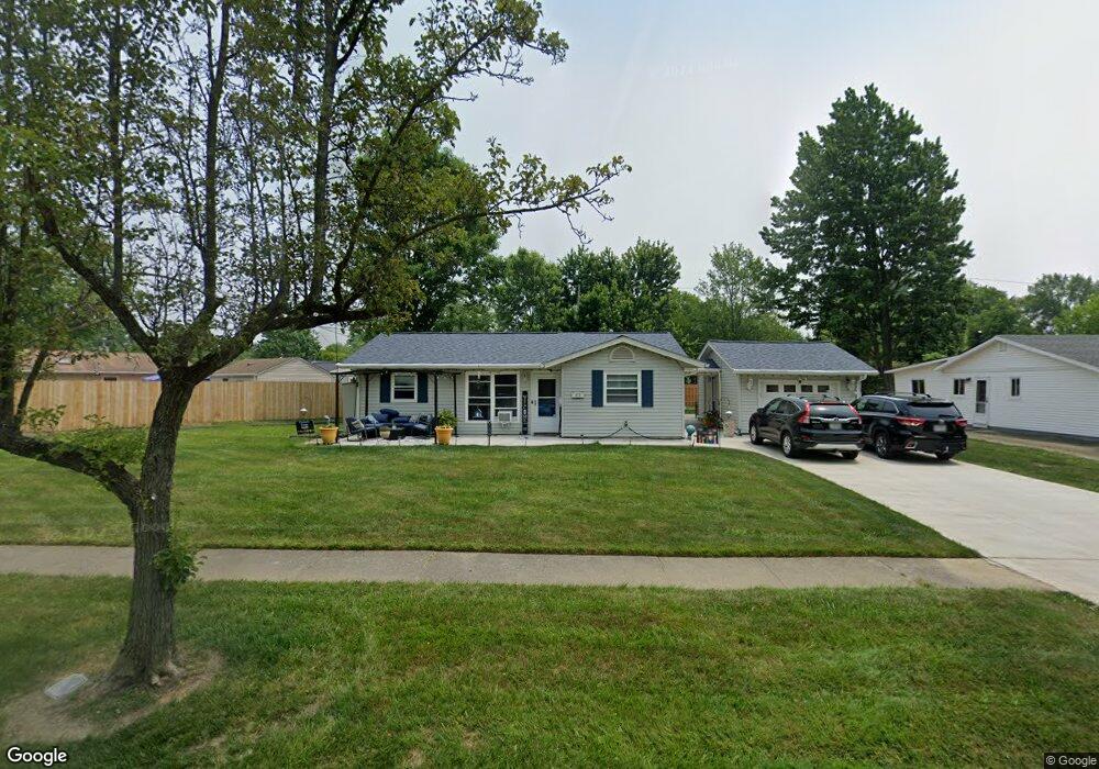
This home is located at 472 Walnut Dr, Berea, OH 44017 and is currently estimated at $244,544, approximately $145 per square foot. 472 Walnut Dr is a home located in Cuyahoga County with nearby schools including Grindstone Elementary School, Berea-Midpark Middle School, and Berea-Midpark High School.
Ownership History
Date
Name
Owned For
Owner Type
Purchase Details
Closed on
Feb 26, 2010
Sold by
Ficociello Gina
Bought by
Mack Michael and Kolenz Melissa A
Current Estimated Value
Home Financials for this Owner
Home Financials are based on the most recent Mortgage that was taken out on this home.
Original Mortgage
$117,826
Outstanding Balance
$80,094
Interest Rate
5.5%
Mortgage Type
FHA
Estimated Equity
$164,450
Purchase Details
Closed on
Jul 1, 2005
Sold by
Sulzer Heidi L
Bought by
Ficociello Gina
Home Financials for this Owner
Home Financials are based on the most recent Mortgage that was taken out on this home.
Original Mortgage
$111,550
Interest Rate
5.75%
Mortgage Type
Fannie Mae Freddie Mac
Purchase Details
Closed on
Dec 14, 1989
Sold by
Sulzer Wm R and Sulzer Rochelle D
Bought by
Sulzer William Ralph
Purchase Details
Closed on
Jan 1, 1975
Bought by
Sulzer Wm R and Sulzer Rochelle D
Create a Home Valuation Report for This Property
The Home Valuation Report is an in-depth analysis detailing your home's value as well as a comparison with similar homes in the area
Home Values in the Area
Average Home Value in this Area
Purchase History
| Date | Buyer | Sale Price | Title Company |
|---|---|---|---|
| Mack Michael | $120,000 | Attorney | |
| Ficociello Gina | $115,000 | Medina County Title | |
| Sulzer William Ralph | -- | -- | |
| Sulzer Wm R | -- | -- |
Source: Public Records
Mortgage History
| Date | Status | Borrower | Loan Amount |
|---|---|---|---|
| Open | Mack Michael | $117,826 | |
| Previous Owner | Ficociello Gina | $111,550 |
Source: Public Records
Tax History
| Year | Tax Paid | Tax Assessment Tax Assessment Total Assessment is a certain percentage of the fair market value that is determined by local assessors to be the total taxable value of land and additions on the property. | Land | Improvement |
|---|---|---|---|---|
| 2024 | $3,991 | $68,915 | $14,840 | $54,075 |
| 2023 | $3,751 | $54,320 | $11,970 | $42,350 |
| 2022 | $3,728 | $54,320 | $11,970 | $42,350 |
| 2021 | $4,616 | $54,320 | $11,970 | $42,350 |
| 2020 | $4,205 | $46,030 | $10,150 | $35,880 |
| 2019 | $3,437 | $131,500 | $29,000 | $102,500 |
| 2018 | $3,415 | $46,030 | $10,150 | $35,880 |
| 2017 | $3,192 | $39,900 | $8,680 | $31,220 |
| 2016 | $3,169 | $39,900 | $8,680 | $31,220 |
| 2015 | $3,153 | $39,900 | $8,680 | $31,220 |
| 2014 | $3,153 | $42,010 | $9,140 | $32,870 |
Source: Public Records
Map
Nearby Homes
- 379 Laurel Dr
- 428 Park Place
- 446 Redwood Dr
- 487 Karen Dr
- 160 Stonepointe Dr
- 628 Lindbergh Blvd
- 445 Berea St
- 404 Crescent Dr
- 146 Marian Ln
- 160 Marian Ln Unit 6A
- 725 Shakespeare Dr
- 93 W 5th Ave
- 287 Edgewood Dr
- 300 West St
- 216 Kraft St
- 41 W 5th Ave
- 211 W Bridge St
- 209 Gibson St
- 6574 Burton Dr
- 550 Race St
- 464 Walnut Dr
- 397 Savage St
- 393 Savage St
- 403 Savage St
- 458 Walnut Dr
- 387 Savage St
- 463 Pecan Dr
- 475 Walnut Dr
- 469 Walnut Dr
- 381 Savage St
- 459 Pecan Dr
- 479 Walnut Dr
- 0 Savage St Unit 3822327
- 0 Savage St Unit 3822326
- 0 Savage St Unit 3822324
- 0 Savage St Unit 3822323
- 0 Savage St Unit 3852526
- 452 Walnut Dr
- 463 Walnut Dr
- 483 Walnut Dr
Your Personal Tour Guide
Ask me questions while you tour the home.