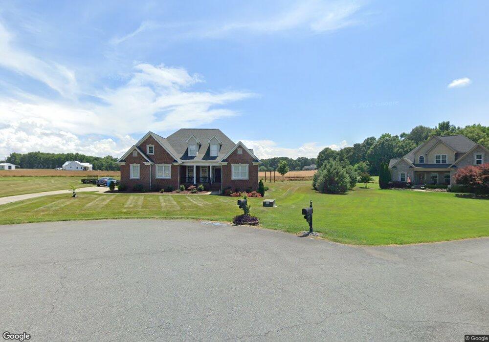
4723 Rollins Pointe Dr Monroe, NC 28110
Estimated Value: $520,000 - $641,000
3
Beds
3
Baths
2,359
Sq Ft
$247/Sq Ft
Est. Value
About This Home
This home is located at 4723 Rollins Pointe Dr, Monroe, NC 28110 and is currently estimated at $583,264, approximately $247 per square foot. 4723 Rollins Pointe Dr is a home located in Union County with nearby schools including Unionville Elementary School, Piedmont Middle School, and Piedmont High School.
Ownership History
Date
Name
Owned For
Owner Type
Purchase Details
Closed on
May 11, 2010
Sold by
Branch Banking & Trust Company
Bought by
Bradley Lance G and Bradley Andrea L
Current Estimated Value
Home Financials for this Owner
Home Financials are based on the most recent Mortgage that was taken out on this home.
Original Mortgage
$230,569
Outstanding Balance
$152,740
Interest Rate
4.97%
Mortgage Type
New Conventional
Estimated Equity
$430,524
Create a Home Valuation Report for This Property
The Home Valuation Report is an in-depth analysis detailing your home's value as well as a comparison with similar homes in the area
Home Values in the Area
Average Home Value in this Area
Purchase History
| Date | Buyer | Sale Price | Title Company |
|---|---|---|---|
| Bradley Lance G | $220,000 | None Available |
Source: Public Records
Mortgage History
| Date | Status | Borrower | Loan Amount |
|---|---|---|---|
| Open | Bradley Lance G | $230,569 |
Source: Public Records
Tax History
| Year | Tax Paid | Tax Assessment Tax Assessment Total Assessment is a certain percentage of the fair market value that is determined by local assessors to be the total taxable value of land and additions on the property. | Land | Improvement |
|---|---|---|---|---|
| 2025 | $3,196 | $628,800 | $0 | $0 |
| 2024 | $2,857 | $422,800 | $57,400 | $365,400 |
| 2023 | $2,830 | $422,800 | $57,400 | $365,400 |
| 2022 | $2,746 | $422,800 | $57,400 | $365,400 |
| 2021 | $2,831 | $422,800 | $57,400 | $365,400 |
| 2020 | $2,068 | $266,500 | $45,000 | $221,500 |
| 2019 | $2,101 | $266,500 | $45,000 | $221,500 |
| 2018 | $2,051 | $266,900 | $45,000 | $221,900 |
| 2017 | $2,184 | $266,900 | $45,000 | $221,900 |
| 2016 | $2,146 | $266,900 | $45,000 | $221,900 |
| 2015 | $2,172 | $266,900 | $45,000 | $221,900 |
| 2014 | $2,071 | $302,160 | $65,000 | $237,160 |
Source: Public Records
Map
Nearby Homes
- 5816 Concord Hwy
- 220 Lawyers Rd
- 600 Ivah Lee Way
- 524 Lawyers Rd W
- 0 Unionville Indian Trail Rd W
- 831 W Unionville Indian Trail Rd
- 835 W Unionville Indian Trail Rd
- 5018 Duncan Rd
- 2608 Wild Azalea Ct
- 2605 Wild Azalea Ct
- 1114 Unionville Indian Trail St Unit 2
- 2820 Smith Field Dr
- 122 E Cj Thomas Rd
- 4933 Campobello Dr
- 2709 Smith Field Dr
- 1319 N Hills Dr
- 1354 Harleston St
- 124 Windsor Greene Dr
- 1444 Harleston St
- 6925 Concord Hwy
- 4727 Rollins Pointe Dr
- 4727 Rollins Pointe Dr Unit Lot 5
- 4726 Rollins Pointe Dr
- 4726 Rollins Pointe Dr Unit Lot 8
- 4722 Rollins Pointe Dr
- 4719 Rollins Pointe Dr
- 4718 Rollins Pointe Dr
- 4731 Rollins Pointe Dr
- 4710 Rollins Pointe Dr
- 00 Rollins Pointe Dr
- 4730 Rollins Pointe Dr
- 5803 Concord Hwy
- 5707 Concord Hwy
- 4715 Rollins Pointe Dr
- 5807 Hwy 601 Hwy
- 4714 Rollins Pointe Dr
- 5809 Concord Hwy
- 5705 Concord Hwy
- 4711 Rollins Pointe Dr
- 5901 Concord Hwy
Your Personal Tour Guide
Ask me questions while you tour the home.