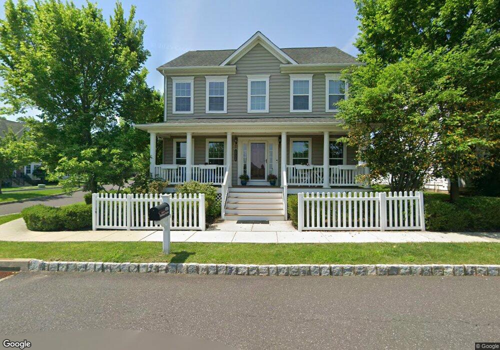
4724 Bishop Cir Doylestown, PA 18902
Plumstead NeighborhoodEstimated Value: $716,000 - $741,384
4
Beds
3
Baths
2,204
Sq Ft
$331/Sq Ft
Est. Value
About This Home
This home is located at 4724 Bishop Cir, Doylestown, PA 18902 and is currently estimated at $728,795, approximately $330 per square foot. 4724 Bishop Cir is a home with nearby schools including Groveland Elementary School, Tohickon Middle School, and Central Bucks High School-West.
Ownership History
Date
Name
Owned For
Owner Type
Purchase Details
Closed on
Mar 30, 2012
Sold by
Nvr Inc
Bought by
Rosiak Christopher J and Rosiak Christine M
Current Estimated Value
Home Financials for this Owner
Home Financials are based on the most recent Mortgage that was taken out on this home.
Original Mortgage
$275,142
Outstanding Balance
$189,774
Interest Rate
3.88%
Mortgage Type
New Conventional
Estimated Equity
$539,021
Purchase Details
Closed on
Nov 18, 2011
Sold by
Carriage Hill Jv Llc
Bought by
Nvr Inc and Nv Homes
Create a Home Valuation Report for This Property
The Home Valuation Report is an in-depth analysis detailing your home's value as well as a comparison with similar homes in the area
Home Values in the Area
Average Home Value in this Area
Purchase History
| Date | Buyer | Sale Price | Title Company |
|---|---|---|---|
| Rosiak Christopher J | $429,910 | None Available | |
| Nvr Inc | $170,000 | None Available |
Source: Public Records
Mortgage History
| Date | Status | Borrower | Loan Amount |
|---|---|---|---|
| Open | Rosiak Christopher J | $275,142 |
Source: Public Records
Tax History Compared to Growth
Tax History
| Year | Tax Paid | Tax Assessment Tax Assessment Total Assessment is a certain percentage of the fair market value that is determined by local assessors to be the total taxable value of land and additions on the property. | Land | Improvement |
|---|---|---|---|---|
| 2025 | $8,283 | $47,670 | $5,470 | $42,200 |
| 2024 | $8,283 | $47,670 | $5,470 | $42,200 |
| 2023 | $8,020 | $47,670 | $5,470 | $42,200 |
| 2022 | $7,930 | $47,670 | $5,470 | $42,200 |
| 2021 | $7,841 | $47,670 | $5,470 | $42,200 |
| 2020 | $7,841 | $47,670 | $5,470 | $42,200 |
| 2019 | $7,794 | $47,670 | $5,470 | $42,200 |
| 2018 | $7,794 | $47,670 | $5,470 | $42,200 |
| 2017 | $7,686 | $47,670 | $5,470 | $42,200 |
| 2016 | $7,686 | $47,670 | $5,470 | $42,200 |
| 2015 | -- | $47,670 | $5,470 | $42,200 |
| 2014 | -- | $47,670 | $5,470 | $42,200 |
Source: Public Records
Map
Nearby Homes
- 4748 Bishop Cir
- 3838 Jacob Stout Rd
- 3765 William Daves Rd
- 3723 William Daves Rd
- 5437 Rinker Cir Unit 283
- 100 Bishops Gate Ln Unit 67
- 114 Blackfriars Cir
- 4263 Kleinot Dr
- 4317 Kleinot Dr
- 4464 Kleinot Dr
- 4330 Kleinot Dr
- 4246 Kleinot Dr
- 4298 Kleinot Dr
- 4306 Kleinot Dr
- 90 Chapman Ave
- 3867 Charter Club Dr
- 418 North St
- 4190 Milords Ln
- 4221 Sir Andrew Cir
- 143 Myers Dr
- 4736 Bishop Cir
- 4725 Abraham Freed Rd
- 4737 Abraham Freed Rd
- 4749 Abraham Freed Rd
- 3985 Christopher Day Rd
- 3832 William Daves Rd Unit 9
- 3832 William Daves Rd Unit 15
- 3832 William Daves Rd Unit 11
- 3832 William Daves Rd Unit 13
- 3832 William Daves Rd Unit 3
- 3832 William Daves Rd
- 3832 William Daves Rd Unit 14
- 3832 William Daves Rd Unit 7
- 3832 William Daves Rd Unit 2
- 3832 William Daves Rd Unit 5
- 3832 William Daves Rd Unit 4
- 3832 William Daves Rd Unit 12
- 3832 William Daves Rd Unit 6
- 3832 William Daves Rd Unit 1
- 3832 William Daves Rd Unit 17