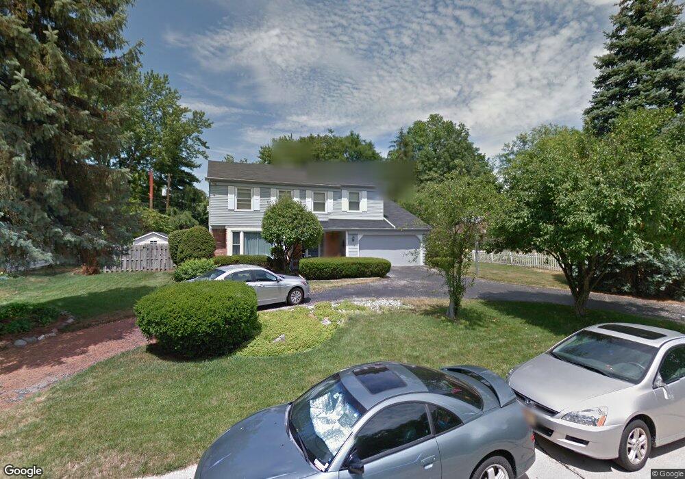
4726 Burningtree Dr Toledo, OH 43623
Franklin Park NeighborhoodEstimated Value: $340,328 - $364,000
4
Beds
3
Baths
2,270
Sq Ft
$153/Sq Ft
Est. Value
About This Home
This home is located at 4726 Burningtree Dr, Toledo, OH 43623 and is currently estimated at $347,582, approximately $153 per square foot. 4726 Burningtree Dr is a home located in Lucas County with nearby schools including Whiteford Elementary School, Sylvania Arbor Hills Junior High School, and Sylvania Southview High School.
Ownership History
Date
Name
Owned For
Owner Type
Purchase Details
Closed on
Dec 5, 1994
Sold by
Trst Dean A Berkey
Bought by
Barton Benjamin and Coburn Cynthia
Current Estimated Value
Purchase Details
Closed on
Mar 29, 1994
Sold by
Berkey Dean A and Berkey Alice
Purchase Details
Closed on
Jan 24, 1994
Sold by
Berkey Dean A and Berkey Alice #
Purchase Details
Closed on
Nov 12, 1993
Sold by
Berkey D J and A J
Create a Home Valuation Report for This Property
The Home Valuation Report is an in-depth analysis detailing your home's value as well as a comparison with similar homes in the area
Home Values in the Area
Average Home Value in this Area
Purchase History
| Date | Buyer | Sale Price | Title Company |
|---|---|---|---|
| Barton Benjamin | $155,000 | -- | |
| -- | -- | -- | |
| -- | -- | -- | |
| -- | -- | -- |
Source: Public Records
Tax History Compared to Growth
Tax History
| Year | Tax Paid | Tax Assessment Tax Assessment Total Assessment is a certain percentage of the fair market value that is determined by local assessors to be the total taxable value of land and additions on the property. | Land | Improvement |
|---|---|---|---|---|
| 2024 | $3,218 | $109,550 | $19,635 | $89,915 |
| 2023 | $5,612 | $83,720 | $15,575 | $68,145 |
| 2022 | $5,644 | $83,720 | $15,575 | $68,145 |
| 2021 | $5,781 | $83,720 | $15,575 | $68,145 |
| 2020 | $5,262 | $69,125 | $12,985 | $56,140 |
| 2019 | $5,069 | $69,125 | $12,985 | $56,140 |
| 2018 | $4,592 | $69,125 | $12,985 | $56,140 |
| 2017 | $4,457 | $57,085 | $11,025 | $46,060 |
| 2016 | $4,372 | $163,100 | $31,500 | $131,600 |
| 2015 | $4,124 | $163,100 | $31,500 | $131,600 |
| 2014 | $3,883 | $54,890 | $10,610 | $44,280 |
| 2013 | $3,883 | $54,890 | $10,610 | $44,280 |
Source: Public Records
Map
Nearby Homes
- 4726 Sutton Place
- 235 Southbridge Rd
- 230 Southbridge Rd
- 4550 Vineyard Rd
- 4632 Beaconsfield Ct
- 4420 Rose Garden Dr Unit 7
- 4259 Rose Garden Dr
- 4806 Vineyard Rd
- 5036 Valencia Dr
- 5025 Homerdale Ave
- 4811 Larkhaven Dr
- 4320 Clarewood Dr
- 4943 Flanders Rd
- 4226 Corey Rd
- 4354 Corey Rd
- 4906 Pine Ridge Rd
- 4757 Maryhill Rd
- 5224 Saddlecreek Rd
- 5162 Kearsdale Rd
- 4824 Skelly Rd
- 4714 Burningtree Dr
- 4736 Burningtree Dr
- 4721 Sutton Place
- 4713 Sutton Place
- 4729 Sutton Place
- 4725 Burningtree Dr
- 4703 Sutton Place
- 4742 Burningtree Dr
- 4737 Sutton Place
- 4428 Old Lyme Dr
- 4422 Old Saybrook Dr
- 4447 Mockingbird Ln
- 4439 Mockingbird Ln
- 4413 Old Saybrook Dr
- 4745 Sutton Place
- 4435 Old Lyme Dr
- 4416 Old Lyme Dr
- 4720 Sutton Place
- 4712 Sutton Place
- 4429 Old Lyme Dr