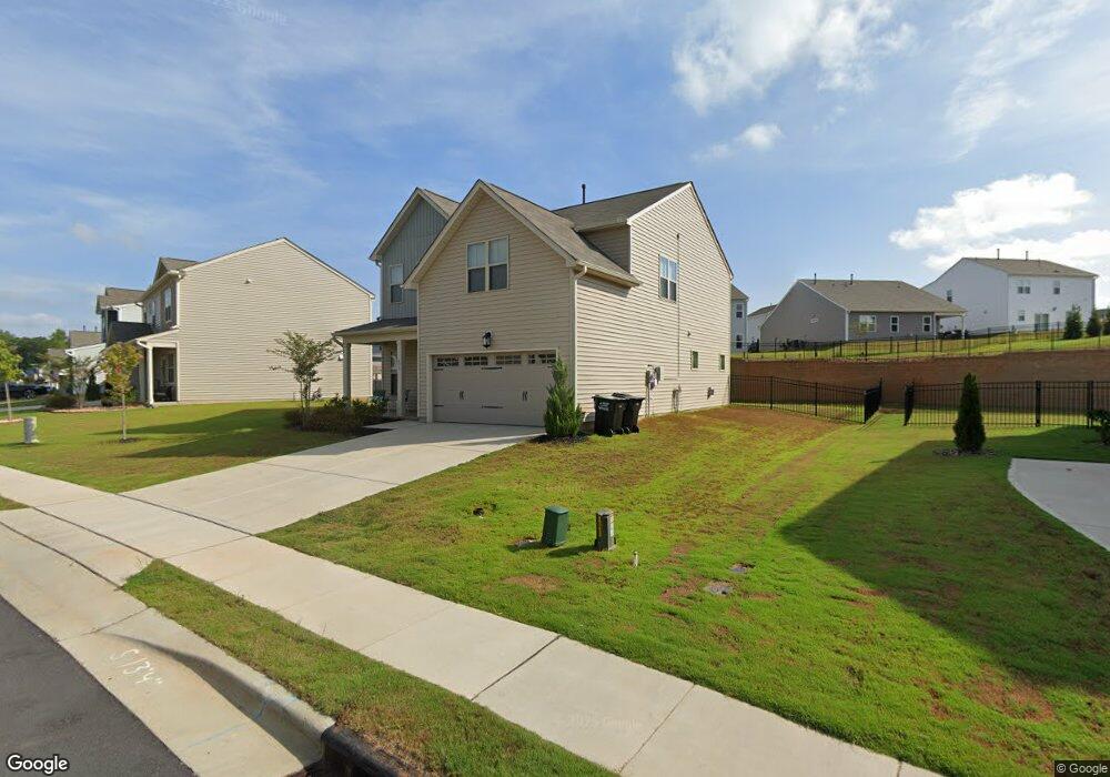
473 W Copenhaver Dr Unit 88 Clayton, NC 27527
Wilders NeighborhoodEstimated Value: $388,000 - $404,489
4
Beds
3
Baths
2,477
Sq Ft
$161/Sq Ft
Est. Value
About This Home
This home is located at 473 W Copenhaver Dr Unit 88, Clayton, NC 27527 and is currently estimated at $398,372, approximately $160 per square foot. 473 W Copenhaver Dr Unit 88 is a home located in Johnston County with nearby schools including Riverwood Middle School, Clayton High, and Thales Academy at Flowers Plantation PreK-7.
Ownership History
Date
Name
Owned For
Owner Type
Purchase Details
Closed on
Apr 20, 2021
Sold by
Nester Dane and Nester Jessica
Bought by
Yearis Allan and Yearis Hart
Current Estimated Value
Home Financials for this Owner
Home Financials are based on the most recent Mortgage that was taken out on this home.
Original Mortgage
$240,000
Outstanding Balance
$216,864
Interest Rate
3.05%
Mortgage Type
New Conventional
Estimated Equity
$181,508
Purchase Details
Closed on
Oct 30, 2019
Sold by
Dr Horton Terramor Llc
Bought by
Nester Dane and Nester Jesscia
Home Financials for this Owner
Home Financials are based on the most recent Mortgage that was taken out on this home.
Original Mortgage
$267,530
Interest Rate
3.7%
Mortgage Type
VA
Purchase Details
Closed on
Jun 12, 2019
Sold by
42 East Llc
Bought by
D R Horton Terramor Llc
Create a Home Valuation Report for This Property
The Home Valuation Report is an in-depth analysis detailing your home's value as well as a comparison with similar homes in the area
Home Values in the Area
Average Home Value in this Area
Purchase History
| Date | Buyer | Sale Price | Title Company |
|---|---|---|---|
| Yearis Allan | $320,500 | None Available | |
| Nester Dane | $262,000 | None Available | |
| D R Horton Terramor Llc | $347,500 | None Available |
Source: Public Records
Mortgage History
| Date | Status | Borrower | Loan Amount |
|---|---|---|---|
| Open | Yearis Allan | $240,000 | |
| Previous Owner | Nester Dane | $267,530 |
Source: Public Records
Tax History Compared to Growth
Tax History
| Year | Tax Paid | Tax Assessment Tax Assessment Total Assessment is a certain percentage of the fair market value that is determined by local assessors to be the total taxable value of land and additions on the property. | Land | Improvement |
|---|---|---|---|---|
| 2025 | $2,448 | $385,580 | $65,000 | $320,580 |
| 2024 | $2,030 | $250,570 | $48,000 | $202,570 |
| 2023 | $2,030 | $250,570 | $48,000 | $202,570 |
| 2022 | $2,055 | $250,570 | $48,000 | $202,570 |
| 2021 | $2,055 | $250,570 | $48,000 | $202,570 |
| 2020 | $2,130 | $250,570 | $48,000 | $202,570 |
Source: Public Records
Map
Nearby Homes
- 49 Cecina Ct
- 208 W Copenhaver Dr
- 222 S Stonehaven Way
- 49 W Copenhaver Dr
- 31 W Copenhaver Dr
- 78 Florence Dr
- 69 Florence Dr
- 210 Sicily Dr
- 154 Sicily Dr
- 78 N Porcenna Ln
- 102 N Porcenna Ln
- 90 Isabella Ct
- 233 Hein Dr
- 112 Castello Way
- 140 E Ravano Dr
- 137 Siena Way
- 243 Grantwood Dr
- 2000 Mountain Laurel Dr
- 47 Whitley Ridge Dr
- 70 Calabria Ct
- 473 W Copenhaver Dr
- 457 W Copenhaver Dr Unit 89
- 487 W Copenhaver Dr Unit 87
- 54 Stornoway Ln
- 54 Stornoway Ln Unit 91
- 443 W Copenhaver Dr
- 443 W Copenhaver Dr Unit 90
- 497 W Copenhaver Dr Unit 86
- 66 Stornoway Ln
- 66 Stornoway Ln Unit 92
- 28 Montalto Ct Unit 94
- 484 W Copenhaver Dr Unit 75
- 484 W Copenhaver Dr
- 466 W Copenhaver Dr
- 466 W Copenhaver Dr Unit 74
- 456 W Copenhaver Dr
- 456 W Copenhaver Dr Unit 73
- 507 W Copenhaver Dr Unit 85
- 34 Montalto Ct Unit 95
- 78 Stornoway Ln Unit 93