

474 Newton Rd Lagrange, GA 30240
Estimated payment $1,665/month
Highlights
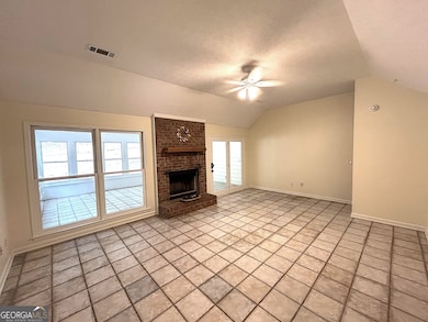
- Vaulted Ceiling
- Traditional Architecture
- No HOA
- Partially Wooded Lot
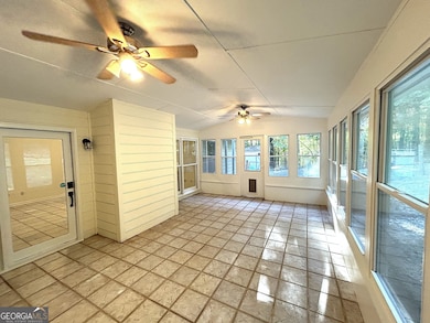
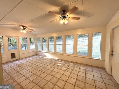
- Sun or Florida Room
- Den
About This Home
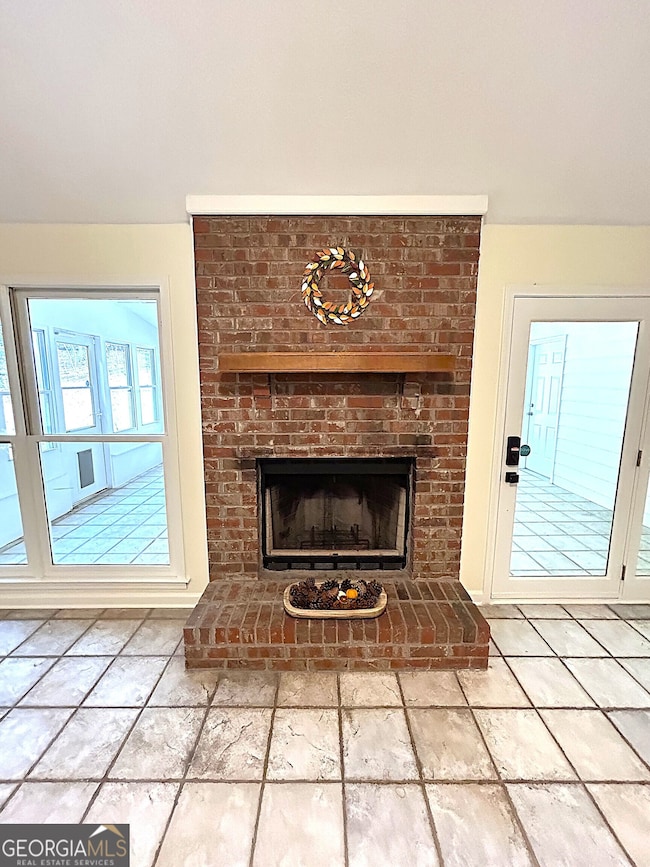
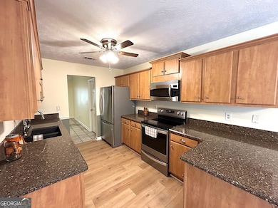
Charming 3-Bedroom with Sunroom & Spacious Living Areas. Step into comfort and style with this beautifully maintained 3-bedroom, 2-bath home designed for relaxed living and effortless entertaining. The inviting living room features elegant tile flooring and a cozy brick fireplace, setting the tone for warm gatherings. Just beyond, the spacious tile sunroom floods with natural light through abundant windows, offering serene views of the fenced backyard-ideal for morning coffee or evening relaxation. A large storage room adjoins the sun room. The primary suite is a true retreat, boasting bamboo flooring, tray ceiling, ceiling fan, and two walk-in closets. The en-suite bath offers spa-like luxury with a tiled finish, dual vanity, garden tub, and separate shower. The kitchen is a chef's delight with gleaming granite countertops, a ceiling fan for added comfort, and stainless-steel appliances, including a refrigerator, convection microwave, range, walk-in pantry and an adjoining breakfast room. A large family room with laminate flooring and dual ceiling fans provides ample space for movie nights or casual lounging. Two additional bedrooms feature laminate flooring and ceiling fans, while the second full bath includes tiled flooring and a shower/tub combo for convenience and style. With thoughtful finishes throughout and plenty of room to spread out, this home blends functionality with charm in every corner. Brand New Roof! Home comes with a 1-Year America's Preferred Home Warranty.
Home Details
Home Type
- Single Family
Est. Annual Taxes
- $2,061
Year Built
- Built in 1991
Lot Details
- 0.78 Acre Lot
- Partially Wooded Lot
Parking
- Parking Pad
Home Design
- Traditional Architecture
- Brick Exterior Construction
- Slab Foundation
- Composition Roof
- Press Board Siding
- Concrete Siding
Interior Spaces
- 2,243 Sq Ft Home
- 1-Story Property
- Tray Ceiling
- Vaulted Ceiling
- Ceiling Fan
- Fireplace Features Masonry
- Entrance Foyer
- Family Room
- Living Room with Fireplace
- Den
- Sun or Florida Room
- Laminate Flooring
- Pull Down Stairs to Attic
- Laundry closet
Kitchen
- Breakfast Area or Nook
- Oven or Range
- Microwave
- Dishwasher
- Stainless Steel Appliances
Bedrooms and Bathrooms
- 3 Main Level Bedrooms
- Split Bedroom Floorplan
- Walk-In Closet
- 2 Full Bathrooms
- Double Vanity
- Soaking Tub
- Bathtub Includes Tile Surround
- Separate Shower
Outdoor Features
- Shed
Schools
- Long Cane Elementary And Middle School
- Troup County High School
Utilities
- Central Heating and Cooling System
- Propane
- Tankless Water Heater
- Septic Tank
- High Speed Internet
- Phone Available
- Cable TV Available
Community Details
- No Home Owners Association
- Wilson Creek Subdivision
Map
Home Values in the Area
Average Home Value in this Area
Tax History
| Year | Tax Paid | Tax Assessment Tax Assessment Total Assessment is a certain percentage of the fair market value that is determined by local assessors to be the total taxable value of land and additions on the property. | Land | Improvement |
|---|---|---|---|---|
| 2024 | $2,007 | $75,580 | $10,000 | $65,580 |
| 2023 | $1,847 | $69,728 | $10,000 | $59,728 |
| 2022 | $1,805 | $66,648 | $10,000 | $56,648 |
| 2021 | $1,689 | $58,000 | $8,000 | $50,000 |
| 2020 | $1,689 | $58,000 | $8,000 | $50,000 |
| 2019 | $1,598 | $54,960 | $8,000 | $46,960 |
| 2018 | $1,546 | $53,260 | $3,700 | $49,560 |
| 2017 | $1,546 | $53,260 | $3,700 | $49,560 |
| 2016 | $1,522 | $52,435 | $3,700 | $48,735 |
| 2015 | $1,523 | $52,373 | $3,700 | $48,673 |
| 2014 | $1,525 | $52,359 | $3,700 | $48,659 |
| 2013 | -- | $52,344 | $3,700 | $48,644 |
Property History
| Date | Event | Price | List to Sale | Price per Sq Ft |
|---|---|---|---|---|
| 10/22/2025 10/22/25 | Price Changed | $283,900 | -2.1% | $127 / Sq Ft |
| 10/13/2025 10/13/25 | Price Changed | $290,000 | -2.9% | $129 / Sq Ft |
| 09/25/2025 09/25/25 | For Sale | $298,700 | -- | $133 / Sq Ft |
Purchase History
| Date | Type | Sale Price | Title Company |
|---|---|---|---|
| Warranty Deed | $124,500 | -- | |
| Quit Claim Deed | -- | -- | |
| Warranty Deed | $84,000 | -- | |
| Warranty Deed | $85,100 | -- | |
| Warranty Deed | $30,800 | -- | |
| Warranty Deed | $32,000 | -- |
Source: Georgia MLS
MLS Number: 10612427
APN: 080-3-001-002
Disclaimer: Certain information contained herein is derived from information provided by parties other than Homes.com. All information provided is deemed reliable, but is not guaranteed to be accurate and should be independently verified.
![]() The data relating to real estate for sale on this web site comes in part from the Broker Reciprocity Program of Georgia MLS. Real estate listings held by brokerage firms other than Redfin are marked with the Broker Reciprocity logo and detailed information about them includes the name of the listing brokers. Information deemed reliable but not guaranteed. Copyright 2025 Georgia MLS. All rights reserved.
The data relating to real estate for sale on this web site comes in part from the Broker Reciprocity Program of Georgia MLS. Real estate listings held by brokerage firms other than Redfin are marked with the Broker Reciprocity logo and detailed information about them includes the name of the listing brokers. Information deemed reliable but not guaranteed. Copyright 2025 Georgia MLS. All rights reserved.
- 40 River Point Dr
- 101 Ivy Springs Dr
- 119 Plymouth Dr
- 102 Franklin Place
- 141 Plymouth Dr
- 108 Hidden Springs Dr
- 1565 Glass Bridge Rd
- 106 Landings Way
- 102 Landings Way
- 201 Lakeview Ct
- 109 Riverbluff Dr
- 135 Planters Ridge Dr
- 101 Riverbluff Dr
- 100 Huntcliff Ct
- 205 Linda Ln
- 102 Foxdale Dr
- 124 Foxdale Dr
- 105 Hawthorne Cir
- 110 Hawthorne Cir
- 0 Deming St Unit 10550189
- 107 Gardenia Ln Unit 107B
- 31 Reed Dr
- 119 Old Airport Rd
- 125 Parker Place
- 1900 Vernon St
- 2200 Abbey Glen Ln
- 604 Freeman St Unit 604 B
- 408 Jackson St
- 702 Jefferson St
- 709 Jefferson St
- 707 Jefferson St
- 615 Jefferson St Unit B
- 1000 3rd Ave
- 1900 Vernon St Unit B1
- 1900 Vernon St Unit A1
- 1900 Vernon St Unit A1A
- 1411 Juniper St
- 304 Boulevard
- 510 Alford St Unit 510B
- 603 W Haralson St Unit 5
