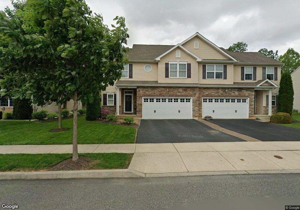
474 Racite Rd Alburtis, PA 18011
Lower Macungie Township West NeighborhoodEstimated Value: $437,000 - $535,000
3
Beds
3
Baths
1,833
Sq Ft
$253/Sq Ft
Est. Value
About This Home
This home is located at 474 Racite Rd, Alburtis, PA 18011 and is currently estimated at $463,059, approximately $252 per square foot. 474 Racite Rd is a home with nearby schools including Alburtis Elementary School, Lower Macungie Middle School, and Emmaus High School.
Ownership History
Date
Name
Owned For
Owner Type
Purchase Details
Closed on
Aug 19, 2014
Sold by
Kay Lock Ridge Llc
Bought by
Miller Loren and Miller Theodore H
Current Estimated Value
Purchase Details
Closed on
Mar 31, 2014
Sold by
Jaindl David M and Jaindl Mark W
Bought by
Kay Lock Ridge Llc
Purchase Details
Closed on
Sep 25, 1978
Sold by
Jaindl Fred J
Bought by
Jaindl Fred J
Create a Home Valuation Report for This Property
The Home Valuation Report is an in-depth analysis detailing your home's value as well as a comparison with similar homes in the area
Home Values in the Area
Average Home Value in this Area
Purchase History
| Date | Buyer | Sale Price | Title Company |
|---|---|---|---|
| Miller Loren | $253,280 | None Available | |
| Kay Lock Ridge Llc | $195,412 | None Available | |
| Jaindl Fred J | $759,400 | -- |
Source: Public Records
Tax History Compared to Growth
Tax History
| Year | Tax Paid | Tax Assessment Tax Assessment Total Assessment is a certain percentage of the fair market value that is determined by local assessors to be the total taxable value of land and additions on the property. | Land | Improvement |
|---|---|---|---|---|
| 2025 | $6,571 | $223,800 | $13,300 | $210,500 |
| 2024 | $6,403 | $223,800 | $13,300 | $210,500 |
| 2023 | $6,107 | $223,800 | $13,300 | $210,500 |
| 2022 | $5,978 | $223,800 | $210,500 | $13,300 |
| 2021 | $5,866 | $223,800 | $13,300 | $210,500 |
| 2020 | $5,817 | $223,800 | $13,300 | $210,500 |
| 2019 | $5,785 | $223,800 | $13,300 | $210,500 |
| 2018 | $5,719 | $223,800 | $13,300 | $210,500 |
| 2017 | $5,632 | $223,800 | $13,300 | $210,500 |
| 2016 | -- | $223,800 | $13,300 | $210,500 |
| 2015 | -- | $434,300 | $13,300 | $421,000 |
Source: Public Records
Map
Nearby Homes
- 317 Lockridge Ln
- 428 Thomas St
- 121 S Main St Unit 123
- 241 Flint Hill Rd
- 354 W 2nd St
- 0 Clauss Hunt Knight Dr Unit 10 Units 763578
- 6903 Lincoln Dr
- 3371 Mathews Ln
- 7230 Pioneer Dr
- 7318 Sauerkraut Ln Unit E
- 6875 Pioneer Dr
- 6709 Mountain Rd
- 31 Barbara Dr
- 0 Mountain Lot 1
- 2845 Donegal Dr
- 2840 Donegal Dr
- 6405 Robin Rd
- 167 Aspen Ln
- 1108 S Barbara Dr
- 7528 Buttercup Rd