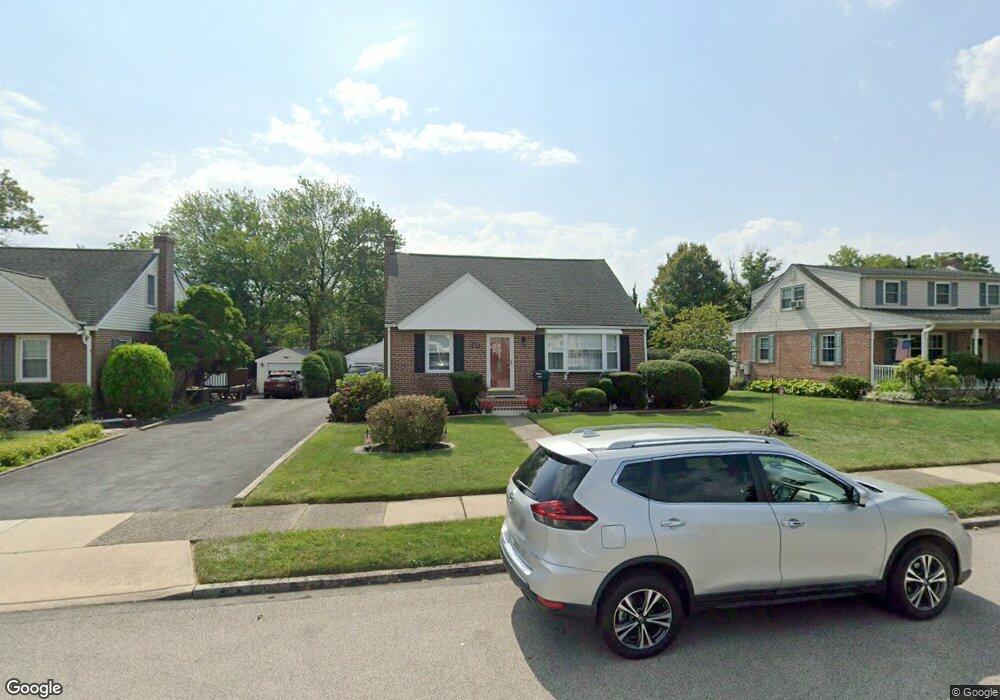
475 Barker Rd Springfield, PA 19064
Estimated Value: $419,000 - $473,000
3
Beds
2
Baths
1,624
Sq Ft
$275/Sq Ft
Est. Value
About This Home
This home is located at 475 Barker Rd, Springfield, PA 19064 and is currently estimated at $446,077, approximately $274 per square foot. 475 Barker Rd is a home located in Delaware County with nearby schools including Springfield High School and St Francis Of Assisi School.
Ownership History
Date
Name
Owned For
Owner Type
Purchase Details
Closed on
Sep 4, 2002
Sold by
Smyth Anna Marion
Bought by
Tomaszewski Stephen M and Saunders Claire E
Current Estimated Value
Home Financials for this Owner
Home Financials are based on the most recent Mortgage that was taken out on this home.
Original Mortgage
$134,750
Outstanding Balance
$56,331
Interest Rate
6.25%
Mortgage Type
Purchase Money Mortgage
Estimated Equity
$389,746
Create a Home Valuation Report for This Property
The Home Valuation Report is an in-depth analysis detailing your home's value as well as a comparison with similar homes in the area
Home Values in the Area
Average Home Value in this Area
Purchase History
| Date | Buyer | Sale Price | Title Company |
|---|---|---|---|
| Tomaszewski Stephen M | $192,500 | Ta Title |
Source: Public Records
Mortgage History
| Date | Status | Borrower | Loan Amount |
|---|---|---|---|
| Open | Tomaszewski Stephen M | $134,750 |
Source: Public Records
Tax History
| Year | Tax Paid | Tax Assessment Tax Assessment Total Assessment is a certain percentage of the fair market value that is determined by local assessors to be the total taxable value of land and additions on the property. | Land | Improvement |
|---|---|---|---|---|
| 2025 | $7,568 | $269,260 | $95,190 | $174,070 |
| 2024 | $7,568 | $269,260 | $95,190 | $174,070 |
| 2023 | $7,287 | $269,260 | $95,190 | $174,070 |
| 2022 | $7,130 | $269,260 | $95,190 | $174,070 |
| 2021 | $11,041 | $269,260 | $95,190 | $174,070 |
| 2020 | $6,471 | $142,810 | $45,760 | $97,050 |
| 2019 | $6,319 | $142,810 | $45,760 | $97,050 |
| 2018 | $6,229 | $142,810 | $0 | $0 |
| 2017 | $6,085 | $142,810 | $0 | $0 |
| 2016 | $784 | $142,810 | $0 | $0 |
| 2015 | $784 | $142,810 | $0 | $0 |
| 2014 | $784 | $142,810 | $0 | $0 |
Source: Public Records
Map
Nearby Homes
- 493 Wheatsheaf Rd
- 227 E Leamy Ave
- 364 S Rolling Rd
- 332 Franklin Ave
- 31 Wayfield Rd
- 1299 Country Club Dr Unit Q141
- 1433 Country Club Dr Unit T214
- 1291 Country Club Dr Unit Q137
- 246 Pennington Ave
- 507 School St
- 226 Lynbrooke Rd
- 978 Westfield Rd
- 1588 Nicklaus Dr Unit H65
- 111 Broad St
- 519 Walnut Ln Unit 1
- 111 Forest Rd
- 7 & 0 Woodland Ave
- 2 Yale Ave
- 147 Snyder Ln
- 1015 Mitchell Ave
- 471 Barker Rd
- 481 Barker Rd
- 478 Granite Terrace
- 465 Barker Rd
- 474 Granite Terrace
- 482 Granite Terrace
- 485 Barker Rd
- 478 Barker Rd
- 468 Granite Terrace
- 472 Barker Rd
- 488 Granite Terrace
- 461 Barker Rd
- 466 Barker Rd
- 409 E Thomson Ave
- 464 Granite Terrace
- 484 Barker Rd
- 493 Barker Rd
- 498 Granite Terrace
- 460 Barker Rd
- 455 Barker Rd
Your Personal Tour Guide
Ask me questions while you tour the home.