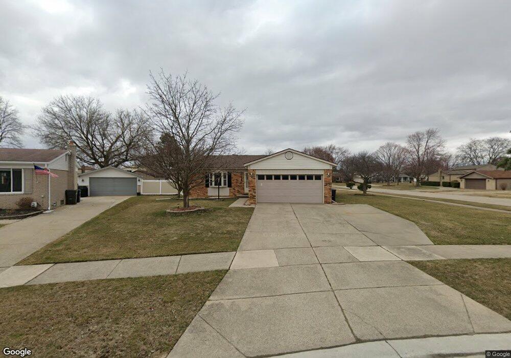
4757 Nathan W Sterling Heights, MI 48310
Estimated Value: $316,000 - $347,000
--
Bed
2
Baths
1,351
Sq Ft
$248/Sq Ft
Est. Value
About This Home
This home is located at 4757 Nathan W, Sterling Heights, MI 48310 and is currently estimated at $334,628, approximately $247 per square foot. 4757 Nathan W is a home located in Macomb County with nearby schools including Schuchard Elementary School, Frank Jeannette Junior High School, and Adlai Stevenson High School.
Ownership History
Date
Name
Owned For
Owner Type
Purchase Details
Closed on
Dec 30, 2024
Sold by
Mitchell Deborah S
Bought by
Mitchell Deborah S and Mitchell Tanya
Current Estimated Value
Purchase Details
Closed on
Jul 26, 2019
Sold by
Mitchell Deborah S and Mitchell Howard L
Bought by
Mitchell Deborah
Home Financials for this Owner
Home Financials are based on the most recent Mortgage that was taken out on this home.
Original Mortgage
$164,835
Interest Rate
4.25%
Mortgage Type
FHA
Purchase Details
Closed on
Feb 20, 1997
Sold by
Ostrowski A
Bought by
Staples R
Create a Home Valuation Report for This Property
The Home Valuation Report is an in-depth analysis detailing your home's value as well as a comparison with similar homes in the area
Home Values in the Area
Average Home Value in this Area
Purchase History
| Date | Buyer | Sale Price | Title Company |
|---|---|---|---|
| Mitchell Deborah S | -- | None Listed On Document | |
| Mitchell Deborah | -- | Lib | |
| Staples R | $139,500 | -- |
Source: Public Records
Mortgage History
| Date | Status | Borrower | Loan Amount |
|---|---|---|---|
| Previous Owner | Mitchell Deborah | $164,835 |
Source: Public Records
Tax History Compared to Growth
Tax History
| Year | Tax Paid | Tax Assessment Tax Assessment Total Assessment is a certain percentage of the fair market value that is determined by local assessors to be the total taxable value of land and additions on the property. | Land | Improvement |
|---|---|---|---|---|
| 2025 | $3,070 | $152,100 | $0 | $0 |
| 2024 | $2,807 | $148,100 | $0 | $0 |
| 2023 | $2,650 | $134,500 | $0 | $0 |
| 2022 | $2,762 | $118,500 | $0 | $0 |
| 2021 | $2,705 | $112,100 | $0 | $0 |
| 2020 | $2,413 | $103,900 | $0 | $0 |
| 2019 | $2,472 | $99,900 | $0 | $0 |
| 2018 | $3,153 | $89,400 | $0 | $0 |
| 2017 | $2,998 | $85,200 | $17,800 | $67,400 |
| 2016 | $2,901 | $85,200 | $0 | $0 |
| 2015 | -- | $77,300 | $0 | $0 |
| 2014 | -- | $65,000 | $0 | $0 |
Source: Public Records
Map
Nearby Homes
- 4768 Dreon Ct
- 39329 Hyland Dr
- 5118 Fredrick Dr
- 38968 Harrison Dr
- 40166 Kristen Dr
- 40034 Kristen Dr
- 40058 Fraser Dr
- 38638 Harrison Dr
- 38576 Cottonwood Dr
- 5477 Victory Cir Unit 70
- 4622 Ardmore Dr
- 4726 Harrow Ct
- 5573 Branch St
- 40444 Harmon Dr
- 3816 Pokley Ct
- 40663 Drury Rd
- 4601 Braebury Ct Unit 506
- 40665 Drury Rd
- 3600 Brandi Dr
- 4539 Carlton Rd