

476967 E 1090 Rd Roland, OK 74954
Estimated payment $1,080/month
Total Views
15,413
--
Bed
--
Bath
4,692
Sq Ft
$42
Price per Sq Ft
Highlights
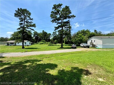
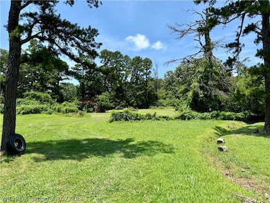
- 3.47 Acre Lot
- Central Heating and Cooling System
- 1-Story Property
- Corner Lot
- Carpet
About This Home
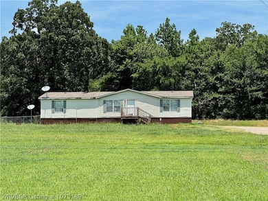
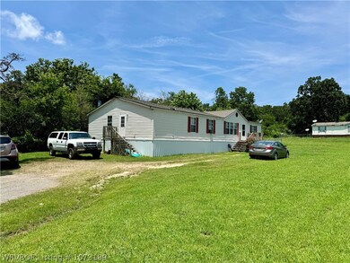
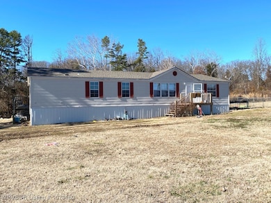
Attention Investors! 3 Unit Opportunity. This property includes 1 home and 2 mobile homes sitting on 3.5 acres of land. There is room to add additional structures or reconfigure the property to fit your needs. A previous mobile home site is availabel behind the house. This is a great location on Swon Rd and just across from the Dollar General north of Roland. This property is tenant occupied please do not disturb.
Home Details
Home Type
- Single Family
Est. Annual Taxes
- $408
Year Built
- Built in 1961
Lot Details
- 3.47 Acre Lot
- Property fronts a county road
- Corner Lot
- Cleared Lot
Home Design
- Shingle Roof
- Asphalt Roof
- Vinyl Siding
- Skirt
Interior Spaces
- 4,692 Sq Ft Home
- 1-Story Property
- Carpet
- Electric Dryer Hookup
Parking
- Gravel Driveway
- Parking Lot
Schools
- Roland Elementary And Middle School
- Roland High School
Utilities
- Central Heating and Cooling System
- Electric Water Heater
Community Details
Listing and Financial Details
- Assessor Parcel Number 0000-10-011-026-0-033-00
Map
Create a Home Valuation Report for This Property
The Home Valuation Report is an in-depth analysis detailing your home's value as well as a comparison with similar homes in the area
Home Values in the Area
Average Home Value in this Area
Tax History
| Year | Tax Paid | Tax Assessment Tax Assessment Total Assessment is a certain percentage of the fair market value that is determined by local assessors to be the total taxable value of land and additions on the property. | Land | Improvement |
|---|---|---|---|---|
| 2025 | $1,188 | $16,545 | $4,418 | $12,127 |
| 2024 | $1,188 | $13,513 | $2,486 | $11,027 |
| 2023 | $429 | $5,688 | $2,486 | $3,202 |
| 2022 | $389 | $5,417 | $2,486 | $2,931 |
| 2021 | $370 | $5,159 | $2,486 | $2,673 |
| 2020 | $165 | $2,300 | $1,108 | $1,192 |
| 2019 | $157 | $2,190 | $1,055 | $1,135 |
| 2018 | $150 | $2,086 | $1,005 | $1,081 |
| 2017 | $143 | $1,986 | $957 | $1,029 |
| 2016 | $136 | $1,892 | $912 | $980 |
| 2015 | $129 | $1,802 | $868 | $934 |
| 2014 | $123 | $1,716 | $759 | $957 |
Source: Public Records
Property History
| Date | Event | Price | List to Sale | Price per Sq Ft |
|---|---|---|---|---|
| 12/18/2025 12/18/25 | Price Changed | $199,000 | -15.3% | $42 / Sq Ft |
| 10/16/2025 10/16/25 | Price Changed | $235,000 | -15.5% | $50 / Sq Ft |
| 09/06/2024 09/06/24 | Price Changed | $278,000 | -7.0% | $59 / Sq Ft |
| 07/02/2024 07/02/24 | For Sale | $299,000 | -- | $64 / Sq Ft |
Source: Western River Valley Board of REALTORS®
Purchase History
| Date | Type | Sale Price | Title Company |
|---|---|---|---|
| Warranty Deed | $175,000 | None Available | |
| Warranty Deed | $56,000 | -- |
Source: Public Records
Mortgage History
| Date | Status | Loan Amount | Loan Type |
|---|---|---|---|
| Open | $164,750 | Commercial |
Source: Public Records
Source: Western River Valley Board of REALTORS®
MLS Number: 1073189
APN: 0000-10-011-026-0-033-00
Nearby Homes
- 108962 Hummingbird Ln
- 109483 S 4770 Rd
- 477053 E 1085 Rd
- 108892 S 4768 Rd
- 476120 E 1091 Rd
- 108714 S 4767 Rd
- 910 James St
- 200 S Jeff Ln
- 511 Mayfield Dr
- 505 Mayfield Dr
- 0000 Cottonwood Rd
- 104 Church St
- 136 Stone Dr
- 138 Stone Dr
- 101 Hollow Dr
- Lot 1 N 4780 Rd
- 113 Cherokee Blvd
- 407 W Ray Fine Blvd
- 405 W Ray Fine Blvd
- TBD W Ray Fine Blvd
- 109 N 3rd St
- 101 N 11th St
- 324 S 12th St
- 1411 Rogers Ave
- 1813 Green Meadow Dr
- 1600 Towson Ave
- 718 N 18th St Unit 4
- 718 N 18th St Unit 4
- 3408 N 6th St
- 618 N 20th St
- 1010 S 19th St Unit 1
- 2117 Beacon Ridge Way
- 604 Belle Ave
- 922 S 23rd St
- 2005 S P St
- 800 S 25th St
- 1813 N 34th Ct
- 2105 S O St
- 1717 S W St
- 1500 Boston St
