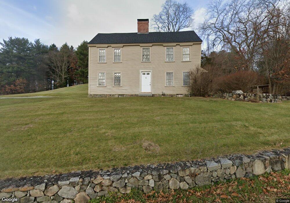
477 Virginia Rd Concord, MA 01742
Estimated Value: $971,000 - $1,462,000
3
Beds
2
Baths
2,359
Sq Ft
$533/Sq Ft
Est. Value
About This Home
This home is located at 477 Virginia Rd, Concord, MA 01742 and is currently estimated at $1,257,136, approximately $532 per square foot. 477 Virginia Rd is a home located in Middlesex County with nearby schools including Alcott Elementary School, Concord Middle School, and Concord Carlisle High School.
Ownership History
Date
Name
Owned For
Owner Type
Purchase Details
Closed on
May 28, 2014
Sold by
New England Farm Lp
Bought by
Lamothe Ronald M and Pearce Karen L
Current Estimated Value
Home Financials for this Owner
Home Financials are based on the most recent Mortgage that was taken out on this home.
Original Mortgage
$412,500
Outstanding Balance
$314,463
Interest Rate
4.26%
Mortgage Type
New Conventional
Estimated Equity
$942,673
Create a Home Valuation Report for This Property
The Home Valuation Report is an in-depth analysis detailing your home's value as well as a comparison with similar homes in the area
Home Values in the Area
Average Home Value in this Area
Purchase History
| Date | Buyer | Sale Price | Title Company |
|---|---|---|---|
| Lamothe Ronald M | $555,000 | -- |
Source: Public Records
Mortgage History
| Date | Status | Borrower | Loan Amount |
|---|---|---|---|
| Open | Lamothe Ronald M | $412,500 |
Source: Public Records
Tax History Compared to Growth
Tax History
| Year | Tax Paid | Tax Assessment Tax Assessment Total Assessment is a certain percentage of the fair market value that is determined by local assessors to be the total taxable value of land and additions on the property. | Land | Improvement |
|---|---|---|---|---|
| 2025 | $149 | $1,122,100 | $687,900 | $434,200 |
| 2024 | $14,131 | $1,076,200 | $642,000 | $434,200 |
| 2023 | $13,281 | $1,024,800 | $611,300 | $413,500 |
| 2022 | $11,652 | $789,400 | $444,400 | $345,000 |
| 2021 | $11,370 | $772,400 | $444,400 | $328,000 |
| 2020 | $10,187 | $715,900 | $388,900 | $327,000 |
| 2019 | $9,951 | $701,300 | $399,100 | $302,200 |
| 2018 | $9,983 | $698,600 | $400,500 | $298,100 |
| 2017 | $9,562 | $679,600 | $381,500 | $298,100 |
| 2016 | $8,822 | $633,800 | $342,300 | $291,500 |
| 2015 | $8,990 | $629,100 | $362,300 | $266,800 |
Source: Public Records
Map
Nearby Homes
- 241 Shadyside Ave
- 26 Kendall Ct Unit 67
- 23 Kendall Ct Unit 23
- 644 Old Bedford Rd
- 7 Blue Heron Way
- 9 Blue Heron Way
- 28 Hatch Farm Ln
- 16 Hatch Farm Ln
- 10 Hatch Farm Ln
- 54 Minot Rd
- 86 Butternut Cir
- 5 South Commons Unit D
- 36 Indian Camp Ln Unit D
- 4 Edmonds Rd Unit 4
- 4 Edmonds Rd
- 20 Selfridge Rd
- 186 Concord Rd
- 4 Greenfield Ln
- 2 Putnam Rd
- 96 Hartwell Rd
- 490 Virginia Rd Unit 11&12
- 490 Virginia Rd Unit 9
- 0 Quail Run Dr Lot 5
- 67 Elm Brook Ln
- 35 Elm Brook Ln
- 55 Elm Brook Ln
- 87 Elm Brook Ln
- 61 Elm Brook Ln
- 56 Elm Brook Ln
- 50 Elm Brook Ln
- 60 Elm Brook Ln
- 2 Peabody Ct
- 8 Peabody Ct
- 12 Peabody Ct
- 90 Elm Brook Ln
- 9 Fuller Ln
- 2 Dunbar Way
- 96 Elm Brook Ln
- 8 Dunbar Way
- 17 Fuller Ln