Estimated payment $23,885/month
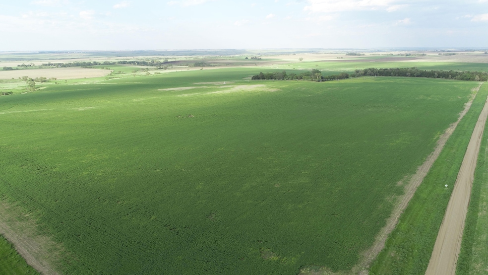
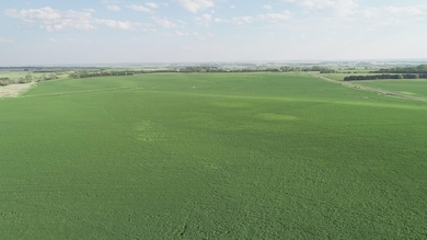
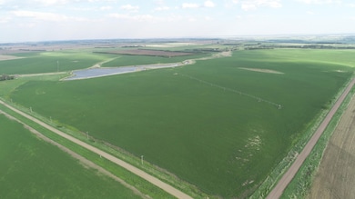
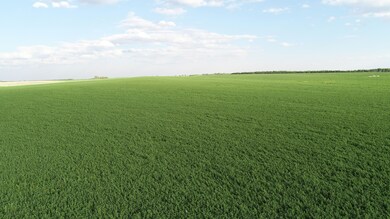
About This Lot
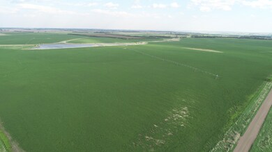
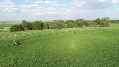
627.6+/- Gross Acres Of Farmland With 4 Pivot Irrigation Systems
Located In McCulley TWP, Boyd County, Nebraska
This Land Is Located Northwest Of Butte, NE & East Of Naper, NE!
This Land Is Pivot Irrigated With 4 Irrigators And Has A Surface Appropriation Permit
To Pump From The Niobrara River!
This Land Was Planted To Alfalfa In June Of 2024
And Has A Great Stand Of Alfalfa Established On The Property !
Location: From the Butte, NE go West on State HWY 12 for approx. 12 miles to the land. Land is located adjacent to State HWY 12 and to 477th Ave. and lies along 477th Ave for 1 1/2 miles and also lies along 904th Rd., (47753 S. 904th RD, Butte, NE)
Agents Note: We are honored to represent the De Hoog family in offering for sale this outstanding property located in Boyd County, NE! This property is owned by the De Hoog family and due to the recent passing of Martin we are offering this property for sale to the public! This land is currently all planted to alfalfa and possession is negotiable depending on time of sale! Call today to receive a full informational packet!
Abbreviated Legal Description: The SW1/4 of Section 10, TWP 34N, Range 14 West of the 6th P.M., Boyd County, NE AND The West 1/2 And the Northeast 1/4 of Section 15, TWP 34N, Range 14 West of the 6th P.M., Boyd County, NE EXCEPTING AN Acreage site located in the Southwest 1/4 thereof.
General Description: This property contains 627.6+/- acres according to the Boyd County Assessor. According to FSA this tract of farmland has approx. 550.34+/- acres considered cropland and approx. 407.+/- permitted irrigated acres under the surface water permit and the balance in dryland/hayland. This farm according to the DNR has a Surface Water appropriation of 407.3+/- acres currently and an appropriation permit number of A-11987. The predominant soil types of the land include: 3305Reliance, 9006-Anselmo, 5220-Onita, 1039-Grigston, 3302-Ree, 3301-Ree, 9004-Anselmo, 3225-Labu-Sansarc, 3240-Mariaville-Paka, 6314-Barmey, 6301-Aowa. This farm has a corn base of 252.27 acres with a PLC yield of 185bu and a soybean base of 27.02 acres with a PLC yield of 39bu. This property has 4 irrigation systems with 3 of the irrigators installed in approx. 2012 and one of the irrigators installed in 2021. The irrigators all consists of Valley irrigators and are all equipped with Ag Sense GPS. The irrigation system on this property is set up to pump out of the Niobrara River to an approx. 12+/- acre reservoir on the property which the irrigation system pumps out of. This property also includes an approx. 3.98 +/- acre building site which includes an approx. 52 x 100 Quonset building with a concrete floor, an approx. 24 x 56 doublewide mobile home and several other outbuildings. This property does have a well which is being used for the mobile home and a older stock well which is no longer in use. If you are looking for a great irrigated property in Boyd County, NE then be sure to take a look at this property! This property also as an added bonus has an established stand of Alfalfa which was just planted in June of 2024!
Irrigation Equipment:
3 Valley 7000 Series 8 Tower IrrigatorsInstalled in Approx. 2012 with new underground conduit
Valley 8 Tower IrrigatorInstalled in approx. 2021
GPS installed on all irrigators which can be controlled from your phone or tablet.
Irrigation pumps: 3-50HP pumps which pump from the reservoir.
Case IH Diesel Engine (approx. 8300 hours) with Crisafulli river pump which pumps from the Niobrara to the pumping canal
Isuzu diesel engine (approx. 4750 hours) with self priming pump which pumps the water from the canal through pipeline to the dam.
Buildings:
Approx. 52 x 100 Quonset building with concrete
24 x 56 double wide mobile home
Power Service Provider: Niobrara Valley Electric
NRBA Name: Niobrara River Basin Alliance
Taxes: Approx. $13,630.00 per year
Closing & Possession Date: Closing and possession is negotiable.
Pricing: Contact Agent For Pricing
Terms: Buyer shall receive a clear and merchantable title to the property on closing day. McCarthy Abstract & Title shall act as closing and escrow agent. Title Insurance and closing fee shall be split 50/50 between the buyer and the seller. This farm is being sold as is as a cash sale with no finance contingencies and as is with any/all defects and encroachments if any. While every effort has been made to ensure the accuracy of the information herein, all prospective buyers are encouraged to inspect the property and verify all data provided. No warranties are expressed or implied. Any lines on maps and pictures are for informational purposes only and are not guaranteed to be actual boundary lines of the property. All buyers are encouraged to do buyers due diligence. Sellers do not warranty or guarantee that existing fences lie on the true boundary and any new fencing if any will be the responsibility of the purchaser pursuant to NE statues. All mineral rights (if any) & water rights (if any) owned by the seller shall be conveyed to the buyer at closing. Buyer is responsible to ensure any pumping and subordination permits are transferred to buyer at closing. All prospective buyers are notified that Zomer Company Realty & Auction and all its representatives are agents of the seller and shall represent the seller throughout the transaction. If any additional information is requested, please contact agents listed below.
De Hoog Family TrustSellers

Property Details
Property Type
- Land
Lot Details
- Property fronts a county road
- Rural Setting
- Lot Has A Rolling Slope
- Sprinkler System
- Current uses include agriculture, row crop, irrigation, homestead
- Potential uses include agriculture
Farming
- Crops include wheat, hay, alfalfa, corn, soybeans
- 1 Stock Tank or Pond
Additional Features
- Wildlife includes pheasants, geese, deer
- 1 Water Well
Map
Tax History
We collect this data history from publicly available records. To have your information removed, we recommend requesting removal directly through your county’s website.
| Year | Tax Paid | Tax Assessment Tax Assessment Total Assessment is a certain percentage of the fair market value that is determined by local assessors to be the total taxable value of land and additions on the property. | Land | Improvement |
|---|---|---|---|---|
| 2025 | $3,837 | $580,735 | $549,530 | $31,205 |
| 2024 | $3,893 | $545,035 | $513,830 | $31,205 |
| 2023 | $5,044 | $479,680 | $448,475 | $31,205 |
| 2022 | $4,969 | $479,680 | $448,475 | $31,205 |
| 2021 | $5,039 | $483,495 | $451,805 | $31,690 |
| 2020 | $5,056 | $480,470 | $448,780 | $31,690 |
| 2019 | $4,908 | $486,365 | $454,675 | $31,690 |
| 2018 | $5,009 | $486,365 | $454,675 | $31,690 |
| 2017 | $5,150 | $480,910 | $454,675 | $26,235 |
| 2016 | $5,249 | $478,730 | $453,595 | $25,135 |
| 2015 | $4,842 | $453,020 | $427,885 | $25,135 |
| 2014 | $4,842 | $352,025 | $342,510 | $9,515 |
| 2012 | $3,118 | $240,160 | $230,490 | $9,670 |
Property History
We collect this data history from publicly available records. To have your information removed, we recommend requesting removal directly through your county’s website.
| Date | Event | Price | List to Sale | Price per Sq Ft |
|---|---|---|---|---|
| 01/24/2026 01/24/26 | Price Changed | $4,350,000 | -9.4% | -- |
| 05/20/2025 05/20/25 | For Sale | $4,800,000 | -- | -- |
Purchase History
We collect this data history from publicly available records. To have your information removed, we recommend requesting removal directly through your county’s website.
| Date | Type | Sale Price | Title Company |
|---|---|---|---|
| Warranty Deed | $1,000,000 | None Listed On Document | |
| Warranty Deed | $1,378,800 | -- |
- 470th Avenue
- 89841 489th Ave
- Lindley Township Hwy
- 503 N Logan St
- 401 N Kuhlman St
- 402 W Main St
- 29501 366th Ave
- Lindley Township Hwy
- 34874 299th
- Elk Dr
- 230 +/- Acres Gregory County
- Lodge Rd
- Tbd Rural Boyd County
- TBD Rural Boyd County
- 193.04 +/- Acres Gregory County
- 62.23 +/- Acres Gregory County
- 1122 Sparks Ave
- 190.79 +/- Acres Gregory County
- 36326 Sd Highway 1806
- 0 S Shore Estates Lot 5 Unit 25-118
Ask me questions while you tour the home.