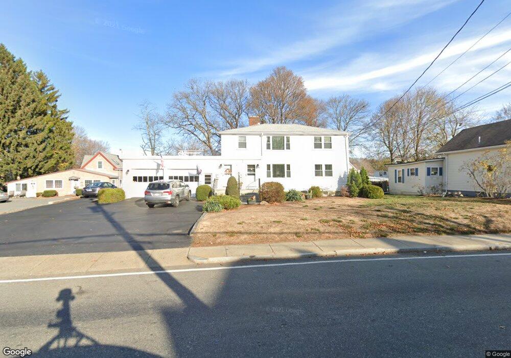
478 Central St Unit 480 Saugus, MA 01906
Cliftondale NeighborhoodEstimated Value: $834,000 - $1,094,000
4
Beds
3
Baths
2,458
Sq Ft
$401/Sq Ft
Est. Value
About This Home
This home is located at 478 Central St Unit 480, Saugus, MA 01906 and is currently estimated at $986,650, approximately $401 per square foot. 478 Central St Unit 480 is a home located in Essex County with nearby schools including Saugus High School, Pioneer Charter School Of Science II, and Sacred Heart School.
Ownership History
Date
Name
Owned For
Owner Type
Purchase Details
Closed on
Aug 8, 1985
Bought by
Braier Anthony M and Braier Joan C
Current Estimated Value
Create a Home Valuation Report for This Property
The Home Valuation Report is an in-depth analysis detailing your home's value as well as a comparison with similar homes in the area
Home Values in the Area
Average Home Value in this Area
Purchase History
| Date | Buyer | Sale Price | Title Company |
|---|---|---|---|
| Braier Anthony M | -- | -- |
Source: Public Records
Tax History Compared to Growth
Tax History
| Year | Tax Paid | Tax Assessment Tax Assessment Total Assessment is a certain percentage of the fair market value that is determined by local assessors to be the total taxable value of land and additions on the property. | Land | Improvement |
|---|---|---|---|---|
| 2025 | $9,327 | $873,300 | $313,400 | $559,900 |
| 2024 | $8,131 | $763,500 | $284,900 | $478,600 |
| 2023 | $7,908 | $702,300 | $256,400 | $445,900 |
| 2022 | $7,785 | $648,200 | $234,600 | $413,600 |
| 2021 | $7,624 | $617,800 | $204,200 | $413,600 |
| 2020 | $6,892 | $578,200 | $194,700 | $383,500 |
| 2019 | $6,811 | $559,200 | $175,700 | $383,500 |
| 2018 | $5,967 | $515,300 | $170,900 | $344,400 |
| 2017 | $5,494 | $455,900 | $159,600 | $296,300 |
| 2016 | $4,416 | $362,000 | $151,800 | $210,200 |
| 2015 | $4,146 | $344,900 | $144,600 | $200,300 |
| 2014 | $4,378 | $377,100 | $144,600 | $232,500 |
Source: Public Records
Map
Nearby Homes
- 483 Central St Unit A
- 4 Foss Ave
- 431 Central St
- 32 Staaf Rd
- 9 Oakwood Ave
- 22 Laconia Ave
- 18 Nason Rd
- 6 Sim Rd Unit 1
- 33 Springdale Ave
- 32-34 Mount Vernon St
- 17 Elaine Ave
- 28 Eustis St
- 12 Seagirt Ave
- 5 Springdale Ave
- 7 Davis St
- 166 Essex St
- 22 Seagirt Ave
- 5 Stanley Terrace
- 25 Auburn St
- 41-43 Seagirt Ave
- 478 Central St
- 478 Central St Unit 2
- 478 Central St Unit 1
- 478 480 Central
- 482 Central St
- 476 Central St
- 42 Birch St
- 474 Central St
- 474 Central St Unit 2
- 474 Central St Unit 1
- 479 Central St
- 479 Central St Unit 2
- 479 Central St Unit 1
- 475 Central St
- 475 Central St Unit 2
- 44 Birch St
- 44 Birch St Unit 1
- 484 Central St
- 6 Stone St
- 473 Central St