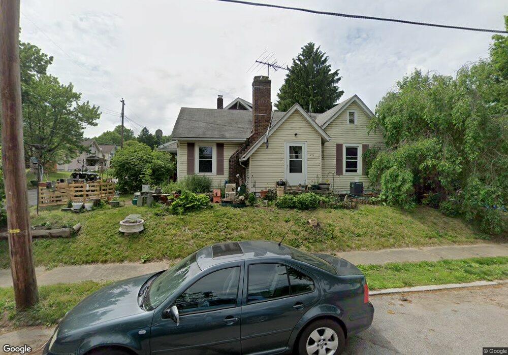
478 Lloyd St Barberton, OH 44203
North Barberton NeighborhoodEstimated Value: $51,000 - $141,997
2
Beds
1
Bath
995
Sq Ft
$92/Sq Ft
Est. Value
About This Home
This home is located at 478 Lloyd St, Barberton, OH 44203 and is currently estimated at $91,499, approximately $91 per square foot. 478 Lloyd St is a home located in Summit County with nearby schools including Barberton Middle School, Barberton High School, and St Augustine Elementary School.
Ownership History
Date
Name
Owned For
Owner Type
Purchase Details
Closed on
Dec 31, 2024
Sold by
Collier Phillip M and Scarito Stephanie A
Bought by
Mnt27 Llc
Current Estimated Value
Purchase Details
Closed on
Mar 11, 2008
Sold by
Krunich Ralph E and Krunich Mary Frances
Bought by
Collier Phillip M and Scarito Stephanie A
Home Financials for this Owner
Home Financials are based on the most recent Mortgage that was taken out on this home.
Original Mortgage
$73,500
Interest Rate
5.74%
Mortgage Type
Purchase Money Mortgage
Create a Home Valuation Report for This Property
The Home Valuation Report is an in-depth analysis detailing your home's value as well as a comparison with similar homes in the area
Home Values in the Area
Average Home Value in this Area
Purchase History
| Date | Buyer | Sale Price | Title Company |
|---|---|---|---|
| Mnt27 Llc | $50,000 | Ohio Fidelity Title | |
| Mnt27 Llc | $50,000 | Ohio Fidelity Title | |
| Collier Phillip M | $73,500 | Firstmerit Title Agency |
Source: Public Records
Mortgage History
| Date | Status | Borrower | Loan Amount |
|---|---|---|---|
| Previous Owner | Collier Phillip M | $73,500 |
Source: Public Records
Tax History Compared to Growth
Tax History
| Year | Tax Paid | Tax Assessment Tax Assessment Total Assessment is a certain percentage of the fair market value that is determined by local assessors to be the total taxable value of land and additions on the property. | Land | Improvement |
|---|---|---|---|---|
| 2025 | $1,526 | $30,527 | $8,442 | $22,085 |
| 2024 | $1,526 | $30,527 | $8,442 | $22,085 |
| 2023 | $1,526 | $30,527 | $8,442 | $22,085 |
| 2022 | $1,108 | $19,230 | $5,149 | $14,081 |
| 2021 | $1,107 | $19,230 | $5,149 | $14,081 |
| 2020 | $1,083 | $19,230 | $5,150 | $14,080 |
| 2019 | $1,286 | $20,680 | $4,890 | $15,790 |
| 2018 | $1,267 | $20,680 | $4,890 | $15,790 |
| 2017 | $1,283 | $20,680 | $4,890 | $15,790 |
| 2016 | $1,286 | $20,680 | $4,890 | $15,790 |
| 2015 | $1,283 | $20,680 | $4,890 | $15,790 |
| 2014 | $1,276 | $20,680 | $4,890 | $15,790 |
| 2013 | $1,314 | $22,070 | $4,890 | $17,180 |
Source: Public Records
Map
Nearby Homes
- 613 Wooster Rd N
- 217 W Summit St
- 0 Wooster Rd N
- 39 Brown St
- 645 Madison Ave
- 46 Brown St
- 320 Lincoln Ave Unit 322
- 636 Wesleyan Ave
- 412 Grandview Ave
- 44 W Summit St
- 344 E Huston St
- 690 Saint Clair Ave
- 349 E Hopocan Ave
- 103 Mitchell St
- 387 4th St NW
- 357 E Paige Ave
- 30 W Hiram St
- 583 Creedmore Ave
- 818 N Summit St
- 589 Highland Ave