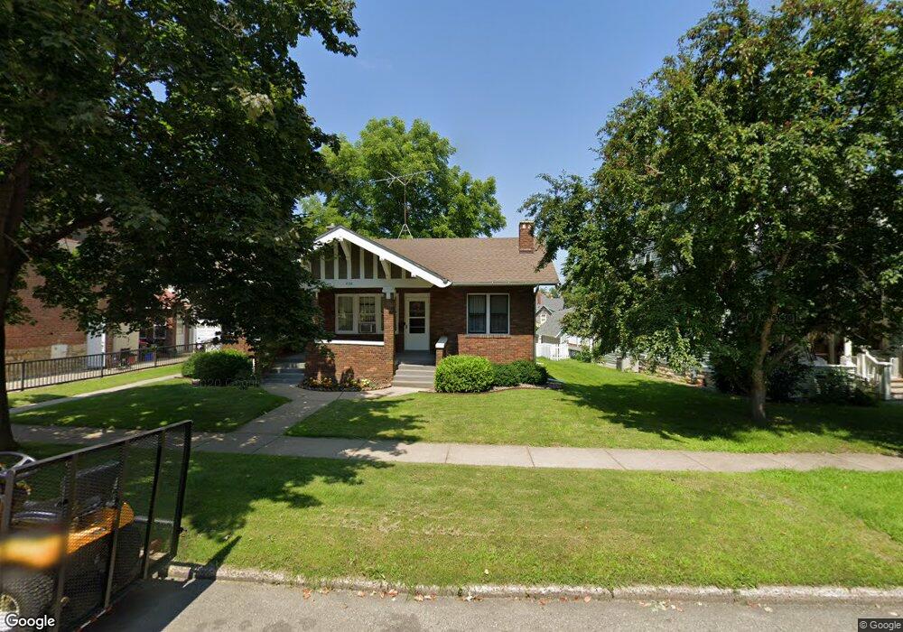
478 W 7th St Red Wing, MN 55066
Estimated Value: $180,000 - $213,000
2
Beds
1
Bath
1,205
Sq Ft
$166/Sq Ft
Est. Value
About This Home
This home is located at 478 W 7th St, Red Wing, MN 55066 and is currently estimated at $199,676, approximately $165 per square foot. 478 W 7th St is a home located in Goodhue County with nearby schools including Sunnyside Elementary School, Burnside Elementary School, and Twin Bluff Middle School.
Ownership History
Date
Name
Owned For
Owner Type
Purchase Details
Closed on
Aug 19, 2022
Sold by
Kees Nicholas
Bought by
Kees Nicholas and Kees Maureen
Current Estimated Value
Purchase Details
Closed on
Dec 7, 2021
Sold by
Kees Maureen and Kees Doughlas
Bought by
Kees Nicholas
Purchase Details
Closed on
Apr 29, 2020
Sold by
Odahlen Hinz Marlene and Hinz Jerry
Bought by
Kees Nicholas Henry
Home Financials for this Owner
Home Financials are based on the most recent Mortgage that was taken out on this home.
Original Mortgage
$44,000
Interest Rate
3.6%
Mortgage Type
Credit Line Revolving
Create a Home Valuation Report for This Property
The Home Valuation Report is an in-depth analysis detailing your home's value as well as a comparison with similar homes in the area
Home Values in the Area
Average Home Value in this Area
Purchase History
| Date | Buyer | Sale Price | Title Company |
|---|---|---|---|
| Kees Nicholas | -- | None Listed On Document | |
| Kees Nicholas | -- | None Available | |
| Kees Nicholas Henry | $70,000 | None Available |
Source: Public Records
Mortgage History
| Date | Status | Borrower | Loan Amount |
|---|---|---|---|
| Previous Owner | Kees Nicholas Henry | $44,000 |
Source: Public Records
Tax History
| Year | Tax Paid | Tax Assessment Tax Assessment Total Assessment is a certain percentage of the fair market value that is determined by local assessors to be the total taxable value of land and additions on the property. | Land | Improvement |
|---|---|---|---|---|
| 2025 | $2,116 | $185,400 | $25,200 | $160,200 |
| 2024 | -- | $182,300 | $25,200 | $157,100 |
| 2023 | $2,060 | $171,600 | $25,100 | $146,500 |
| 2022 | $1,848 | $170,500 | $25,100 | $145,400 |
| 2021 | $1,684 | $144,100 | $25,100 | $119,000 |
| 2020 | $2,298 | $134,900 | $25,100 | $109,800 |
| 2019 | $2,268 | $145,100 | $25,100 | $120,000 |
| 2018 | $1,856 | $144,900 | $24,400 | $120,500 |
| 2017 | $1,808 | $125,700 | $24,400 | $101,300 |
| 2016 | $1,344 | $123,900 | $24,400 | $99,500 |
| 2015 | $1,274 | $119,900 | $24,400 | $95,500 |
| 2014 | -- | $114,500 | $24,400 | $90,100 |
Source: Public Records
Map
Nearby Homes
- 463 8th St
- 402 W 7th St
- 320 W 7th St
- 831 Central Ave
- 520 10th St
- 617 W 3rd St
- 222 Bush St Unit 402
- 222 Bush St Unit 302
- 222 Bush St Unit 404
- 222 Bush St Unit 303
- 222 Bush St Unit 301
- 222 Bush St Unit 304
- 222 Bush St Unit 401
- 815 W 4th St
- 418 Franklin St
- 1004 College Ave
- 910 W 4th St
- 225 E 5th St
- 462 13th St
- 1050 Sturtevant St
Your Personal Tour Guide
Ask me questions while you tour the home.