Estimated Value: $368,000 - $468,000
4
Beds
2
Baths
1,920
Sq Ft
$212/Sq Ft
Est. Value
About This Home
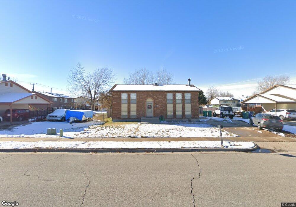
This home is located at 4781 S 3600 W, Roy, UT 84067 and is currently estimated at $407,459, approximately $212 per square foot. 4781 S 3600 W is a home located in Weber County with nearby schools including West Haven School, Sand Ridge Junior High School, and Roy High School.
Ownership History
Date
Name
Owned For
Owner Type
Purchase Details
Closed on
Jun 2, 2025
Sold by
Moser Mackinsy and Cain Joshua
Bought by
Cain Mackinsy and Cain Joshua
Current Estimated Value
Home Financials for this Owner
Home Financials are based on the most recent Mortgage that was taken out on this home.
Original Mortgage
$130,000
Outstanding Balance
$128,645
Interest Rate
5.94%
Mortgage Type
New Conventional
Estimated Equity
$278,814
Purchase Details
Closed on
Apr 22, 2016
Bought by
Moore Christy L
Home Financials for this Owner
Home Financials are based on the most recent Mortgage that was taken out on this home.
Original Mortgage
$250,000
Interest Rate
3.59%
Purchase Details
Closed on
May 30, 2008
Sold by
Wilson Cheryl L
Bought by
Moore Timothy R
Home Financials for this Owner
Home Financials are based on the most recent Mortgage that was taken out on this home.
Original Mortgage
$169,569
Interest Rate
6.05%
Mortgage Type
VA
Create a Home Valuation Report for This Property
The Home Valuation Report is an in-depth analysis detailing your home's value as well as a comparison with similar homes in the area
Home Values in the Area
Average Home Value in this Area
Purchase History
| Date | Buyer | Sale Price | Title Company |
|---|---|---|---|
| Cain Mackinsy | -- | Stewart Title | |
| Moore Christy L | -- | -- | |
| Moore Timothy R | -- | Mountain View Title Ogden |
Source: Public Records
Mortgage History
| Date | Status | Borrower | Loan Amount |
|---|---|---|---|
| Open | Cain Mackinsy | $130,000 | |
| Previous Owner | Moore Christy L | $250,000 | |
| Previous Owner | Moore Christy L | -- | |
| Previous Owner | Moore Timothy R | $169,569 |
Source: Public Records
Tax History
| Year | Tax Paid | Tax Assessment Tax Assessment Total Assessment is a certain percentage of the fair market value that is determined by local assessors to be the total taxable value of land and additions on the property. | Land | Improvement |
|---|---|---|---|---|
| 2025 | $2,077 | $367,974 | $123,041 | $244,933 |
| 2024 | $2,028 | $199,099 | $67,672 | $131,427 |
| 2023 | $2,047 | $201,301 | $55,743 | $145,558 |
| 2022 | $2,109 | $211,200 | $54,327 | $156,873 |
| 2021 | $1,607 | $267,000 | $70,165 | $196,835 |
| 2020 | $1,531 | $233,000 | $70,165 | $162,835 |
| 2019 | $1,482 | $213,000 | $43,259 | $169,741 |
| 2018 | $1,493 | $203,000 | $39,120 | $163,880 |
| 2017 | $1,319 | $169,000 | $39,120 | $129,880 |
| 2016 | $1,198 | $82,744 | $20,576 | $62,168 |
| 2015 | $1,007 | $71,760 | $20,576 | $51,184 |
| 2014 | $941 | $66,309 | $20,576 | $45,733 |
Source: Public Records
Map
Nearby Homes
- 3517 W 4835 S Unit 27
- 3509 W 4835 S Unit 26
- 4813 S 3850 W
- 3878 W 4700 S
- 4950 3900 West St
- 3405 W 4525 S
- 3610 W 4475 S
- 4602 S 4000 W
- 4491 Haven Creek Rd Unit A
- 4024 W 4650 S
- 4435 Cross Creek Rd Unit 29C
- 3443 W 5200 S Unit 2&3
- 4101 W 4600 S
- 3808 W 4300 S
- 4322 S 3450 W
- 4317 S 3350 W
- 4324 S 3350 W
- 4088 W 5050 S
- 4096 W 5075 S
- 5155 S 3200 W
Your Personal Tour Guide
Ask me questions while you tour the home.