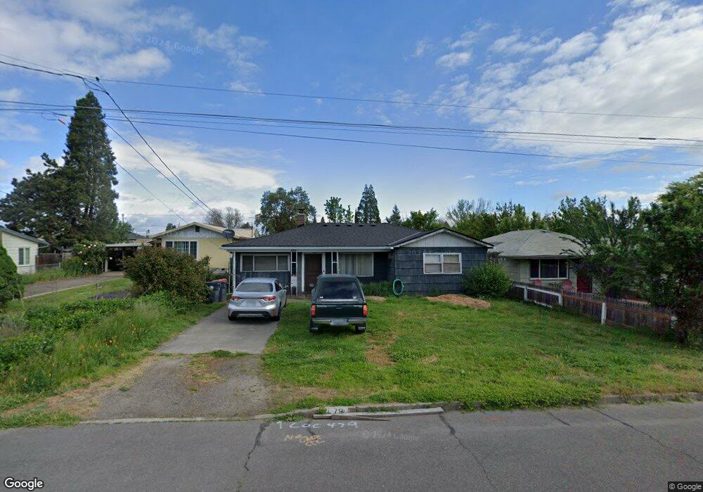
479 Grand Ave Central Point, OR 97502
Estimated Value: $274,000 - $334,000
3
Beds
1
Bath
1,113
Sq Ft
$265/Sq Ft
Est. Value
About This Home
This home is located at 479 Grand Ave, Central Point, OR 97502 and is currently estimated at $294,955, approximately $265 per square foot. 479 Grand Ave is a home located in Jackson County with nearby schools including Central Point Elementary School, Scenic Middle School, and Crater High School.
Ownership History
Date
Name
Owned For
Owner Type
Purchase Details
Closed on
May 13, 2025
Sold by
Gordon Steven R and Gordon Rosemary
Bought by
Steven R And Rosemary Gordon Living Trust and Gordon
Current Estimated Value
Purchase Details
Closed on
Feb 2, 1998
Sold by
Watson Mark L and Watson Andrea J
Bought by
Gordon Steven R and Gordon Rosemary
Home Financials for this Owner
Home Financials are based on the most recent Mortgage that was taken out on this home.
Original Mortgage
$54,060
Interest Rate
6.95%
Mortgage Type
VA
Create a Home Valuation Report for This Property
The Home Valuation Report is an in-depth analysis detailing your home's value as well as a comparison with similar homes in the area
Purchase History
| Date | Buyer | Sale Price | Title Company |
|---|---|---|---|
| Steven R And Rosemary Gordon Living Trust | -- | None Listed On Document | |
| Gordon Steven R | $53,000 | Amerititle |
Source: Public Records
Mortgage History
| Date | Status | Borrower | Loan Amount |
|---|---|---|---|
| Previous Owner | Gordon Steven R | $54,060 |
Source: Public Records
Tax History
| Year | Tax Paid | Tax Assessment Tax Assessment Total Assessment is a certain percentage of the fair market value that is determined by local assessors to be the total taxable value of land and additions on the property. | Land | Improvement |
|---|---|---|---|---|
| 2026 | $2,034 | $122,890 | -- | -- |
| 2025 | $1,984 | $119,320 | $61,210 | $58,110 |
| 2024 | $1,984 | $115,850 | $59,430 | $56,420 |
| 2023 | $1,920 | $112,480 | $57,700 | $54,780 |
| 2022 | $1,875 | $112,480 | $57,700 | $54,780 |
| 2021 | $1,822 | $109,210 | $56,020 | $53,190 |
| 2020 | $1,769 | $106,030 | $54,390 | $51,640 |
| 2019 | $1,725 | $99,960 | $51,270 | $48,690 |
| 2018 | $1,673 | $97,050 | $49,780 | $47,270 |
| 2017 | $1,631 | $97,050 | $49,780 | $47,270 |
| 2016 | $1,583 | $91,490 | $46,930 | $44,560 |
| 2015 | $1,501 | $91,490 | $46,930 | $44,560 |
| 2014 | $1,442 | $86,250 | $44,250 | $42,000 |
Source: Public Records
Map
Nearby Homes
- 555 Freeman Rd Unit 73
- 555 Freeman Rd Unit 254
- 555 Freeman Rd Unit 105
- 555 Freeman Rd Unit 209
- 755 S 4th St
- 114 Cedar St
- 350 Alder St
- 220 S 3rd St
- 736 Hemlock Ave
- 301 Freeman Rd Unit 30
- 301 Freeman Rd Unit 92
- 436 Cheney Loop
- 1065 Edwina Ave
- 3364 Bursell Rd
- 887 Silver Fox Dr
- 144 N 5th St
- 533 Brittni Ln
- 3358 Bursell Rd
- 230 Peninger Rd
- 556 Glenn Way
Your Personal Tour Guide
Ask me questions while you tour the home.