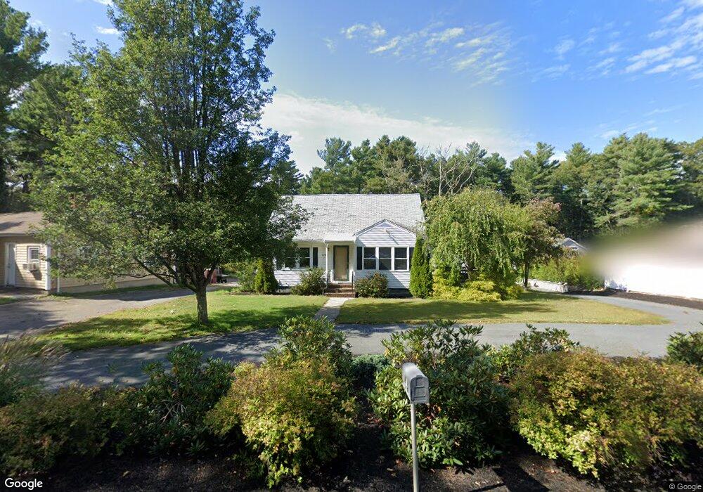
479 Main St Acushnet, MA 02743
Upper Acushnet NeighborhoodEstimated Value: $445,798 - $508,000
Studio
2
Baths
1,220
Sq Ft
$396/Sq Ft
Est. Value
About This Home
This home is located at 479 Main St, Acushnet, MA 02743 and is currently estimated at $483,450, approximately $396 per square foot. 479 Main St is a home located in Bristol County with nearby schools including Acushnet Elementary School, Albert F Ford Middle School, and Alma Del Mar Charter School.
Ownership History
Date
Name
Owned For
Owner Type
Purchase Details
Closed on
Dec 29, 2017
Sold by
Goyette Russell W
Bought by
Goyette Ryan W
Current Estimated Value
Home Financials for this Owner
Home Financials are based on the most recent Mortgage that was taken out on this home.
Original Mortgage
$200,000
Outstanding Balance
$167,238
Interest Rate
3.95%
Mortgage Type
New Conventional
Estimated Equity
$316,212
Purchase Details
Closed on
Nov 26, 2008
Sold by
Goyette Joanne E and Goyette Russell W
Bought by
Goyette Russell W
Purchase Details
Closed on
Dec 21, 1999
Sold by
Wingert Arline M
Bought by
Goyette Russell W and Goyette Joanne E
Home Financials for this Owner
Home Financials are based on the most recent Mortgage that was taken out on this home.
Original Mortgage
$140,900
Interest Rate
7.81%
Mortgage Type
Purchase Money Mortgage
Create a Home Valuation Report for This Property
The Home Valuation Report is an in-depth analysis detailing your home's value as well as a comparison with similar homes in the area
Home Values in the Area
Average Home Value in this Area
Purchase History
| Date | Buyer | Sale Price | Title Company |
|---|---|---|---|
| Goyette Ryan W | $250,000 | -- | |
| Goyette Russell W | -- | -- | |
| Goyette Russell W | $149,900 | -- |
Source: Public Records
Mortgage History
| Date | Status | Borrower | Loan Amount |
|---|---|---|---|
| Open | Goyette Ryan W | $200,000 | |
| Previous Owner | Goyette Russell W | $140,900 |
Source: Public Records
Tax History
| Year | Tax Paid | Tax Assessment Tax Assessment Total Assessment is a certain percentage of the fair market value that is determined by local assessors to be the total taxable value of land and additions on the property. | Land | Improvement |
|---|---|---|---|---|
| 2025 | $40 | $370,000 | $138,500 | $231,500 |
| 2024 | $3,876 | $339,700 | $131,200 | $208,500 |
| 2023 | $3,888 | $324,000 | $119,100 | $204,900 |
| 2022 | $3,931 | $296,200 | $111,800 | $184,400 |
| 2021 | $3,693 | $267,000 | $111,800 | $155,200 |
| 2020 | $3,620 | $259,700 | $104,500 | $155,200 |
| 2019 | $3,459 | $243,900 | $99,600 | $144,300 |
| 2018 | $2,829 | $233,800 | $99,600 | $134,200 |
| 2017 | $3,271 | $226,500 | $99,600 | $126,900 |
| 2016 | $3,297 | $226,900 | $99,600 | $127,300 |
| 2015 | $3,060 | $214,300 | $99,600 | $114,700 |
Source: Public Records
Map
Nearby Homes
- 489 Main St
- 363 Main St
- 25 Pershing Ave
- 23 Oliveira Ave
- 191 Hathaway Rd
- 0 Hathaway Rd Unit 73469544
- 12 White St
- 329 Middle Rd
- 7 Hamlin St
- 0 Land Way Unit 73479153
- 11 Boylston St
- 23 Coury Dr
- 14 Hayes St Unit 1
- 12 Hayes St Unit 1
- 134 Nyes Ln
- 27 Meadow Ln
- 15 Ball St
- 65 Armsby St
- 122 Truro St
- 1027 Kenmore St
Your Personal Tour Guide
Ask me questions while you tour the home.