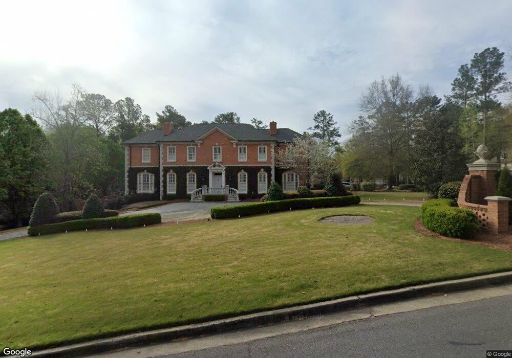
4792 Brae Burn Ln Macon, GA 31210
Estimated Value: $911,000 - $1,842,125
5
Beds
9
Baths
6,396
Sq Ft
$204/Sq Ft
Est. Value
About This Home
This home is located at 4792 Brae Burn Ln, Macon, GA 31210 and is currently estimated at $1,302,042, approximately $203 per square foot. 4792 Brae Burn Ln is a home located in Bibb County with nearby schools including Carter Elementary School, Howard Middle School, and Howard High School.
Ownership History
Date
Name
Owned For
Owner Type
Purchase Details
Closed on
Oct 26, 2011
Sold by
Smisson Jane L
Bought by
Smisson Md Hugh F
Current Estimated Value
Create a Home Valuation Report for This Property
The Home Valuation Report is an in-depth analysis detailing your home's value as well as a comparison with similar homes in the area
Home Values in the Area
Average Home Value in this Area
Purchase History
| Date | Buyer | Sale Price | Title Company |
|---|---|---|---|
| Smisson Md Hugh F | -- | None Available |
Source: Public Records
Tax History Compared to Growth
Tax History
| Year | Tax Paid | Tax Assessment Tax Assessment Total Assessment is a certain percentage of the fair market value that is determined by local assessors to be the total taxable value of land and additions on the property. | Land | Improvement |
|---|---|---|---|---|
| 2025 | $15,363 | $625,158 | $50,400 | $574,758 |
| 2024 | $15,877 | $625,158 | $50,400 | $574,758 |
| 2023 | $17,084 | $576,759 | $50,400 | $526,359 |
| 2022 | $18,387 | $531,105 | $28,800 | $502,305 |
| 2021 | $18,948 | $498,630 | $28,800 | $469,830 |
| 2020 | $18,290 | $471,098 | $24,000 | $447,098 |
| 2019 | $16,789 | $428,881 | $24,000 | $404,881 |
| 2018 | $26,071 | $428,881 | $24,000 | $404,881 |
| 2017 | $16,068 | $428,881 | $24,000 | $404,881 |
| 2016 | $14,838 | $428,881 | $24,000 | $404,881 |
| 2015 | $19,102 | $390,074 | $24,000 | $366,074 |
| 2014 | $19,131 | $390,074 | $24,000 | $366,074 |
Source: Public Records
Map
Nearby Homes
- 4768 Brae Burn Ln
- 0 Saint Andrews Dr Unit 8094183
- 0 Saint Andrews Dr Unit 8094180
- 0 Saint Andrews Dr Unit 8716811
- 0 Saint Andrews Dr Unit 7225346
- 0 Saint Andrews Dr Unit 7162830
- 0 Saint Andrews Dr
- 1098 Saint Andrews Dr
- 4781 Brae Burn Ln
- 1106 Saint Andrews Dr
- 4750 Brae Burn Ln Unit 17
- 4765` Brae Burn Ln
- 4765 Brae Burn Ln
- 1078 Saint Andrews Dr
- 1071 Saint Andrews Dr
- 1112 St Andrews Dr
- 1112 Saint Andrews Dr
- 4749 Brae Burn Ln
- 103 Troon Way
- 4736 Brae Burn Ln