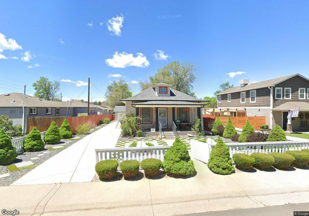
4795 S Sherman St Englewood, CO 80113
Bellewood NeighborhoodEstimated Value: $531,000 - $622,000
2
Beds
2
Baths
1,092
Sq Ft
$523/Sq Ft
Est. Value
About This Home
This home is located at 4795 S Sherman St, Englewood, CO 80113 and is currently estimated at $571,639, approximately $523 per square foot. 4795 S Sherman St is a home located in Arapahoe County with nearby schools including Cherrelyn Elementary School, Englewood Middle School, and Englewood High School.
Ownership History
Date
Name
Owned For
Owner Type
Purchase Details
Closed on
Mar 15, 2012
Sold by
North Joanne M and Estate Of Sharron G Vandel
Bought by
Francisco Conrado S and Francisco Eleanor T
Current Estimated Value
Home Financials for this Owner
Home Financials are based on the most recent Mortgage that was taken out on this home.
Original Mortgage
$123,600
Outstanding Balance
$85,026
Interest Rate
3.9%
Mortgage Type
New Conventional
Estimated Equity
$486,613
Purchase Details
Closed on
Sep 6, 2005
Sold by
Vandel Sharron G
Bought by
Vandel Sharron G and Vandel Joe A
Create a Home Valuation Report for This Property
The Home Valuation Report is an in-depth analysis detailing your home's value as well as a comparison with similar homes in the area
Home Values in the Area
Average Home Value in this Area
Purchase History
| Date | Buyer | Sale Price | Title Company |
|---|---|---|---|
| Francisco Conrado S | $154,500 | None Available | |
| Francisco Conrado S | -- | Heritage Title | |
| Vandel Sharron G | -- | -- |
Source: Public Records
Mortgage History
| Date | Status | Borrower | Loan Amount |
|---|---|---|---|
| Open | Francisco Conrado S | $123,600 |
Source: Public Records
Tax History Compared to Growth
Tax History
| Year | Tax Paid | Tax Assessment Tax Assessment Total Assessment is a certain percentage of the fair market value that is determined by local assessors to be the total taxable value of land and additions on the property. | Land | Improvement |
|---|---|---|---|---|
| 2024 | $2,560 | $36,388 | -- | -- |
| 2023 | $2,560 | $36,388 | $0 | $0 |
| 2022 | $1,770 | $24,297 | $0 | $0 |
| 2021 | $1,763 | $24,297 | $0 | $0 |
| 2020 | $1,592 | $21,679 | $0 | $0 |
| 2019 | $1,582 | $21,679 | $0 | $0 |
| 2018 | $1,495 | $19,116 | $0 | $0 |
| 2017 | $1,481 | $19,116 | $0 | $0 |
| 2016 | $1,365 | $16,684 | $0 | $0 |
| 2015 | $1,127 | $16,684 | $0 | $0 |
| 2014 | -- | $13,906 | $0 | $0 |
| 2013 | -- | $14,950 | $0 | $0 |
Source: Public Records
Map
Nearby Homes
- 4874 S Lincoln St
- 4822 S Grant St
- 4703 S Sherman St
- 4893 S Sherman St
- 4720 S Grant St
- 4680 S Sherman St
- 4728 S Acoma St
- 4779 S Bannock St
- 4786 S Cherokee St
- 4794 S Pearl St
- 4816 S Delaware St
- 4588 S Cherokee St
- 4519 S Pennsylvania St
- 664 S Washington Cir
- 5108 S Pennsylvania St
- 4800 S Fox St
- 4420 S Grant St
- 4406 S Acoma St
- 5180 S Logan St
- 5136 S Pennsylvania St
- 4795 S Sherman St
- 4785 S Sherman St
- 4799 S Sherman St
- 4775 S Sherman St
- 4788 S Lincoln St
- 4755 S Sherman St
- 4780 S Lincoln St
- 4796 S Lincoln St
- 4750 S Lincoln St
- 4788 S Sherman St
- 4790 S Sherman St
- 4780 S Sherman St
- 4801 S Sherman St
- 4749 S Sherman St
- 4770 S Sherman St
- 4748 S Lincoln St
- 4800 S Lincoln St
- 4800 R S Lincoln St
- 4760 S Sherman St
- 4815 S Sherman St