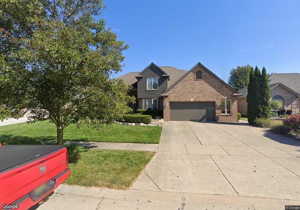
47972 Stanford Dr Macomb, MI 48044
Estimated Value: $454,020 - $567,000
Studio
2
Baths
2,538
Sq Ft
$199/Sq Ft
Est. Value
About This Home
This home is located at 47972 Stanford Dr, Macomb, MI 48044 and is currently estimated at $506,005, approximately $199 per square foot. 47972 Stanford Dr is a home located in Macomb County with nearby schools including Cheyenne Elementary School, Seneca Middle School, and Dakota High School.
Ownership History
Date
Name
Owned For
Owner Type
Purchase Details
Closed on
Aug 25, 2024
Sold by
Fogolini Joseph R and Fogolini Lori
Bought by
Fogolini Joseph R and Fogolini Lori
Current Estimated Value
Purchase Details
Closed on
Aug 31, 2001
Sold by
Biundo Building Corp
Bought by
Fogolini Joseph R
Purchase Details
Closed on
May 8, 2001
Sold by
M & C Ltd Of Utica
Bought by
Biundo Building Corp
Create a Home Valuation Report for This Property
The Home Valuation Report is an in-depth analysis detailing your home's value as well as a comparison with similar homes in the area
Home Values in the Area
Average Home Value in this Area
Purchase History
| Date | Buyer | Sale Price | Title Company |
|---|---|---|---|
| Fogolini Joseph R | -- | None Listed On Document | |
| Fogolini Joseph R | -- | None Listed On Document | |
| Fogolini Joseph R | $248,000 | -- | |
| Biundo Building Corp | $70,967 | -- |
Source: Public Records
Mortgage History
| Date | Status | Borrower | Loan Amount |
|---|---|---|---|
| Closed | Fogolini Joseph R | -- |
Source: Public Records
Tax History
| Year | Tax Paid | Tax Assessment Tax Assessment Total Assessment is a certain percentage of the fair market value that is determined by local assessors to be the total taxable value of land and additions on the property. | Land | Improvement |
|---|---|---|---|---|
| 2025 | $4,109 | $227,800 | $0 | $0 |
| 2024 | $40 | $221,500 | $0 | $0 |
| 2023 | $3,790 | $200,100 | $0 | $0 |
| 2022 | $4,751 | $178,800 | $0 | $0 |
| 2021 | $4,622 | $166,600 | $0 | $0 |
| 2020 | $3,477 | $163,700 | $0 | $0 |
| 2019 | $4,278 | $156,500 | $0 | $0 |
| 2018 | $4,169 | $152,800 | $0 | $0 |
| 2017 | $4,104 | $146,790 | $34,500 | $112,290 |
| 2016 | $3,895 | $146,790 | $0 | $0 |
| 2015 | $3,844 | $138,260 | $0 | $0 |
| 2014 | $3,844 | $123,860 | $23,500 | $100,360 |
| 2013 | $2,811 | $123,860 | $0 | $0 |
Source: Public Records
Map
Nearby Homes
- 19732 Fillmore Dr
- 48274 Beacon Square Dr
- 48498 Beacon Square Dr
- 20350 Hummingbird Ln
- 20776 Wexford Dr
- 19424 Norway Pine Dr
- 20580 21 Mile Rd
- 50675-50811 Romeo Plank Rd
- 19852 Keats Ct
- 49281 Lehr Dr
- 48767 Brittany Parc Dr
- 19201 Grisham Dr
- 21122 Summerfield Dr
- 47983 Sage Dr
- 21220 Briar Rose Dr
- 19389 Lakeland Dr
- 21258 Fairfield Dr
- 48088 Greenbriar Dr
- 18894 Via Firenze
- 49683 Yale Dr
- 47946 Stanford Dr
- 47998 Stanford Dr
- 47927 Jamestown Dr
- 47901 Jamestown Dr
- 47920 Stanford Dr
- 47953 Jamestown Dr
- 19858 Nob Hill Dr
- 47875 Jamestown Dr
- 48024 Stanford Dr
- 47959 Stanford Dr
- 47979 Jamestown Dr
- 47894 Stanford Dr
- 19897 Nob Hill Dr
- 47933 Stanford Dr
- 19830 Nob Hill Dr
- 47849 Jamestown Dr
- 19869 Nob Hill Dr
- 48005 Jamestown Dr
- 47907 Stanford Dr
- 47868 Stanford Dr
Your Personal Tour Guide
Ask me questions while you tour the home.