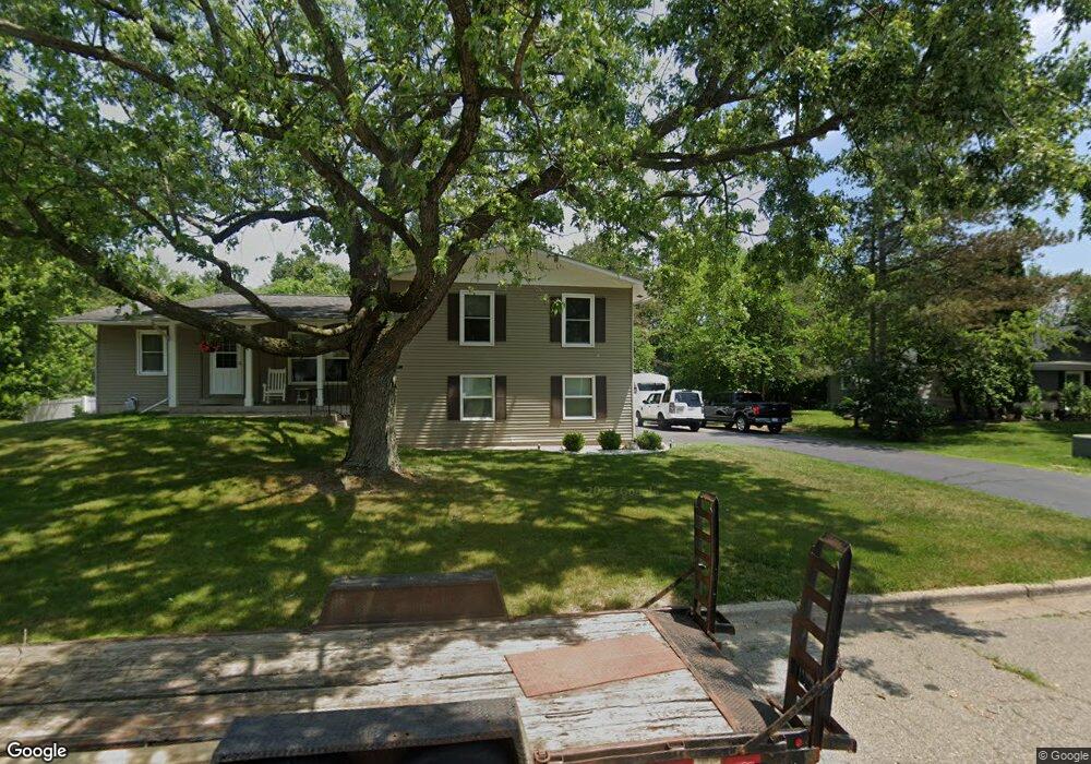
4798 Norfolk Cir Portage, MI 49024
Estimated Value: $317,103 - $351,000
--
Bed
1
Bath
2,192
Sq Ft
$152/Sq Ft
Est. Value
About This Home
This home is located at 4798 Norfolk Cir, Portage, MI 49024 and is currently estimated at $333,276, approximately $152 per square foot. 4798 Norfolk Cir is a home located in Kalamazoo County with nearby schools including 12th Street Elementary School, Portage West Middle School, and Portage Central High School.
Ownership History
Date
Name
Owned For
Owner Type
Purchase Details
Closed on
Nov 5, 2021
Sold by
Theodore J Wietke Ii Trust
Bought by
Jecks Trina Marie
Current Estimated Value
Home Financials for this Owner
Home Financials are based on the most recent Mortgage that was taken out on this home.
Original Mortgage
$224,266
Interest Rate
3.05%
Mortgage Type
FHA
Purchase Details
Closed on
May 14, 2021
Sold by
Wietke Theodore J
Bought by
Wietke Theodore J and Theodore J Wietke Ii Trust
Create a Home Valuation Report for This Property
The Home Valuation Report is an in-depth analysis detailing your home's value as well as a comparison with similar homes in the area
Home Values in the Area
Average Home Value in this Area
Purchase History
| Date | Buyer | Sale Price | Title Company |
|---|---|---|---|
| Jecks Trina Marie | $259,000 | None Listed On Document | |
| Wietke Theodore J | -- | None Available |
Source: Public Records
Mortgage History
| Date | Status | Borrower | Loan Amount |
|---|---|---|---|
| Previous Owner | Jecks Trina Marie | $224,266 |
Source: Public Records
Tax History Compared to Growth
Tax History
| Year | Tax Paid | Tax Assessment Tax Assessment Total Assessment is a certain percentage of the fair market value that is determined by local assessors to be the total taxable value of land and additions on the property. | Land | Improvement |
|---|---|---|---|---|
| 2025 | $5,946 | $147,900 | $0 | $0 |
| 2024 | $5,351 | $142,500 | $0 | $0 |
| 2023 | $5,100 | $115,300 | $0 | $0 |
| 2022 | $6,274 | $99,400 | $0 | $0 |
| 2021 | $4,110 | $91,600 | $0 | $0 |
| 2020 | $4,026 | $92,400 | $0 | $0 |
| 2019 | $303 | $91,400 | $0 | $0 |
| 2018 | $0 | $87,100 | $0 | $0 |
| 2017 | $0 | $84,300 | $0 | $0 |
| 2016 | -- | $82,300 | $0 | $0 |
| 2015 | -- | $74,000 | $0 | $0 |
| 2014 | -- | $68,300 | $0 | $0 |
Source: Public Records
Map
Nearby Homes
- 4788 Norfolk Cir
- 7873 Shepherds Glen Ct
- 7951 S 12th St
- 3653 Tartan Cir
- 7566 Cobblewood Dr
- 7895 Deerpath Rd
- 7296 Annandale Dr
- 5420 Whippoorwill Dr
- 5464 Cypress Bay Dr
- 7236 Hampstead Ln Unit 18
- 5660 Saddle Club Dr
- 6794 Brickleton Ct
- 3737 Bellflower Dr
- 7175 Hopkinton Dr
- 7922 Kilmory Cir
- 8030 Wimbledon Dr Unit 35
- 7337 Roslindale Trail
- 3638 Bellflower Dr
- 6971 Annandale Dr
- 5189 Queen Victoria Ln
- 4808 Norfolk Cir
- 4790 Norfolk Cir
- 4818 Norfolk Cir
- 4803 Norfolk Cir
- 4793 Norfolk Cir
- 4778 Norfolk Cir
- 4813 Norfolk Cir
- 4783 Norfolk Cir
- 4776 Norfolk Cir
- 4725 Norfolk Cir
- 4735 Norfolk Cir
- 4735 Norfolk Cir
- 4828 Norfolk Cir
- 4845 Norfolk Cir
- 4717 Norfolk Cir Unit 2
- 4717 Norfolk Cir
- 4745 Norfolk Cir
- 4715 Norfolk Cir
- 4768 Norfolk Cir
- 4855 Norfolk Cir