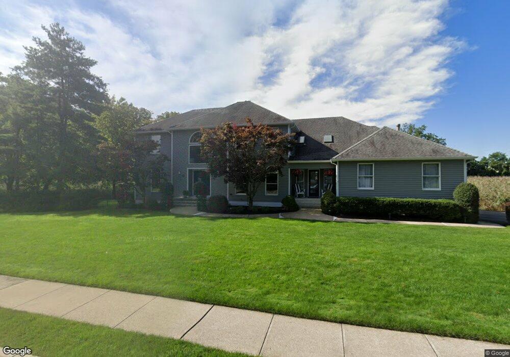
48 Blades Run Shrewsbury, NJ 07702
Estimated Value: $1,209,016 - $1,484,000
4
Beds
2
Baths
3,099
Sq Ft
$436/Sq Ft
Est. Value
About This Home
This home is located at 48 Blades Run, Shrewsbury, NJ 07702 and is currently estimated at $1,350,254, approximately $435 per square foot. 48 Blades Run is a home located in Monmouth County with nearby schools including Shrewsbury Elementary School, Red Bank Reg High School, and Ranney School.
Ownership History
Date
Name
Owned For
Owner Type
Purchase Details
Closed on
Jul 7, 2011
Sold by
Kostelnik Michael and Kostelnik Pamela
Bought by
Kolodjeski Andrew and Kolodjeski Laura
Current Estimated Value
Home Financials for this Owner
Home Financials are based on the most recent Mortgage that was taken out on this home.
Original Mortgage
$516,000
Outstanding Balance
$354,657
Interest Rate
4.49%
Mortgage Type
New Conventional
Estimated Equity
$995,597
Purchase Details
Closed on
Aug 5, 1998
Sold by
Wheaton David
Bought by
Kostelink Michael and Kostelink Pamela
Home Financials for this Owner
Home Financials are based on the most recent Mortgage that was taken out on this home.
Original Mortgage
$227,000
Interest Rate
6.9%
Create a Home Valuation Report for This Property
The Home Valuation Report is an in-depth analysis detailing your home's value as well as a comparison with similar homes in the area
Home Values in the Area
Average Home Value in this Area
Purchase History
| Date | Buyer | Sale Price | Title Company |
|---|---|---|---|
| Kolodjeski Andrew | $645,000 | Chicago Title Insurance Co | |
| Kostelink Michael | $365,000 | -- |
Source: Public Records
Mortgage History
| Date | Status | Borrower | Loan Amount |
|---|---|---|---|
| Open | Kolodjeski Andrew | $516,000 | |
| Previous Owner | Kostelink Michael | $227,000 |
Source: Public Records
Tax History Compared to Growth
Tax History
| Year | Tax Paid | Tax Assessment Tax Assessment Total Assessment is a certain percentage of the fair market value that is determined by local assessors to be the total taxable value of land and additions on the property. | Land | Improvement |
|---|---|---|---|---|
| 2025 | $16,255 | $912,300 | $346,000 | $566,300 |
| 2024 | $16,312 | $887,300 | $332,800 | $554,500 |
| 2023 | $16,312 | $865,800 | $323,100 | $542,700 |
| 2022 | $15,878 | $783,200 | $323,100 | $460,100 |
| 2021 | $15,878 | $748,600 | $293,800 | $454,800 |
| 2020 | $15,619 | $735,700 | $293,800 | $441,900 |
| 2019 | $15,506 | $722,900 | $293,800 | $429,100 |
| 2018 | $15,384 | $715,200 | $293,800 | $421,400 |
| 2017 | $14,905 | $697,800 | $289,300 | $408,500 |
| 2016 | $14,017 | $664,300 | $259,300 | $405,000 |
| 2015 | $14,151 | $650,300 | $255,800 | $394,500 |
| 2014 | $14,239 | $627,000 | $250,800 | $376,200 |
Source: Public Records
Map
Nearby Homes
- 125 Broad St
- 70 Driftwood Cir
- 32 Villa Place
- 19 Villa Place
- 82 Sunnybank Dr
- 9 Sandbar Alley
- 32 Tinton Ave
- 72 White St Unit A
- 57 White St Unit D
- 73 White St Unit C
- 99 White St Unit D
- 25 Signal Ave
- 292 Crawford St
- 276 Crawford St
- 459 Sycamore Ave
- 12 Barton Ave
- 450 Sycamore Ave
- 104 Garden Rd
- 21 Buttonwood Dr
- 76 Belshaw Ave