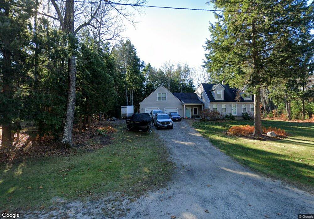
48 Cemetery Rd Buxton, ME 04093
Estimated Value: $467,000 - $535,000
3
Beds
1
Bath
1,343
Sq Ft
$371/Sq Ft
Est. Value
About This Home
This home is located at 48 Cemetery Rd, Buxton, ME 04093 and is currently estimated at $497,772, approximately $370 per square foot. 48 Cemetery Rd is a home located in York County with nearby schools including Bonny Eagle High School.
Ownership History
Date
Name
Owned For
Owner Type
Purchase Details
Closed on
Mar 12, 2019
Sold by
Gallant Brad D
Bought by
Gallant Brad D and Gallant Betsey
Current Estimated Value
Home Financials for this Owner
Home Financials are based on the most recent Mortgage that was taken out on this home.
Original Mortgage
$224,000
Interest Rate
4.2%
Mortgage Type
Stand Alone Refi Refinance Of Original Loan
Purchase Details
Closed on
Nov 23, 2015
Sold by
Gallant Karen L
Bought by
Gallant Brad D
Home Financials for this Owner
Home Financials are based on the most recent Mortgage that was taken out on this home.
Original Mortgage
$204,000
Interest Rate
3.79%
Mortgage Type
Commercial
Purchase Details
Closed on
Sep 4, 2007
Sold by
Dusseault Mark W
Bought by
Gallant Karen L and Gallant Brad D
Create a Home Valuation Report for This Property
The Home Valuation Report is an in-depth analysis detailing your home's value as well as a comparison with similar homes in the area
Home Values in the Area
Average Home Value in this Area
Purchase History
| Date | Buyer | Sale Price | Title Company |
|---|---|---|---|
| Gallant Brad D | -- | -- | |
| Gallant Brad D | -- | -- | |
| Gallant Brad D | -- | -- | |
| Gallant Brad D | -- | -- | |
| Gallant Brad D | -- | -- | |
| Gallant Brad D | -- | -- | |
| Gallant Karen L | -- | -- | |
| Gallant Brad D | -- | -- | |
| Gallant Karen L | -- | -- |
Source: Public Records
Mortgage History
| Date | Status | Borrower | Loan Amount |
|---|---|---|---|
| Previous Owner | Gallant Brad D | $224,000 | |
| Previous Owner | Gallant Brad D | $204,000 |
Source: Public Records
Tax History Compared to Growth
Tax History
| Year | Tax Paid | Tax Assessment Tax Assessment Total Assessment is a certain percentage of the fair market value that is determined by local assessors to be the total taxable value of land and additions on the property. | Land | Improvement |
|---|---|---|---|---|
| 2024 | $4,633 | $421,600 | $105,000 | $316,600 |
| 2023 | $4,397 | $421,600 | $105,000 | $316,600 |
| 2022 | $4,320 | $421,900 | $105,000 | $316,900 |
| 2021 | $3,644 | $252,002 | $64,900 | $187,102 |
| 2020 | $3,674 | $252,002 | $64,900 | $187,102 |
| 2019 | $3,311 | $223,400 | $64,900 | $158,500 |
| 2018 | $3,159 | $223,400 | $64,900 | $158,500 |
| 2017 | $3,038 | $223,400 | $64,900 | $158,500 |
| 2016 | $2,617 | $200,500 | $64,900 | $135,600 |
| 2015 | $2,596 | $200,500 | $64,900 | $135,600 |
| 2014 | -- | $200,500 | $64,900 | $135,600 |
| 2013 | $2,506 | $200,500 | $64,900 | $135,600 |
Source: Public Records
Map
Nearby Homes
- 22 Finn Parker Rd
- 125 Old Thompson Rd
- 14 Patrick Dr
- 00 Ossipee Trail E
- 21 Alexander Dr
- 30 Joan Dixon Way
- 135 Buck St
- 183 Buck St
- 35 Rust Rd
- 116 Dingley Spring Rd
- 379 Bonny Eagle Rd
- Lot 2 Commerce Way
- 95 Skip Rd
- 62 Emery Cir
- 47 Proprietors Rd
- 17 Fox Track
- 580 Bonny Eagle Rd
- 63 Ossipee Trail E
- 15 Winter St
- 27 Ossipee Trail E Unit 1
- 54 Cemetery Rd
- 40 Cemetery Rd
- 49 Cemetery Rd
- 43 Cemetery Rd
- 60 Cemetery Rd
- 55 Cemetery Rd
- 30 Cemetery Rd
- 35 Cemetery Rd
- 61 Cemetery Rd
- 68 Cemetery Rd
- 896 Parker Farm Rd
- 26 Cemetery Rd
- 67 Cemetery Rd
- 50 Line Rd
- 888 Parker Farm Rd
- 72 Cemetery Rd
- 21 Cemetery Rd
- 912 Parker Farm Rd
- 18 Cemetery Rd
- 79 Cemetery Rd