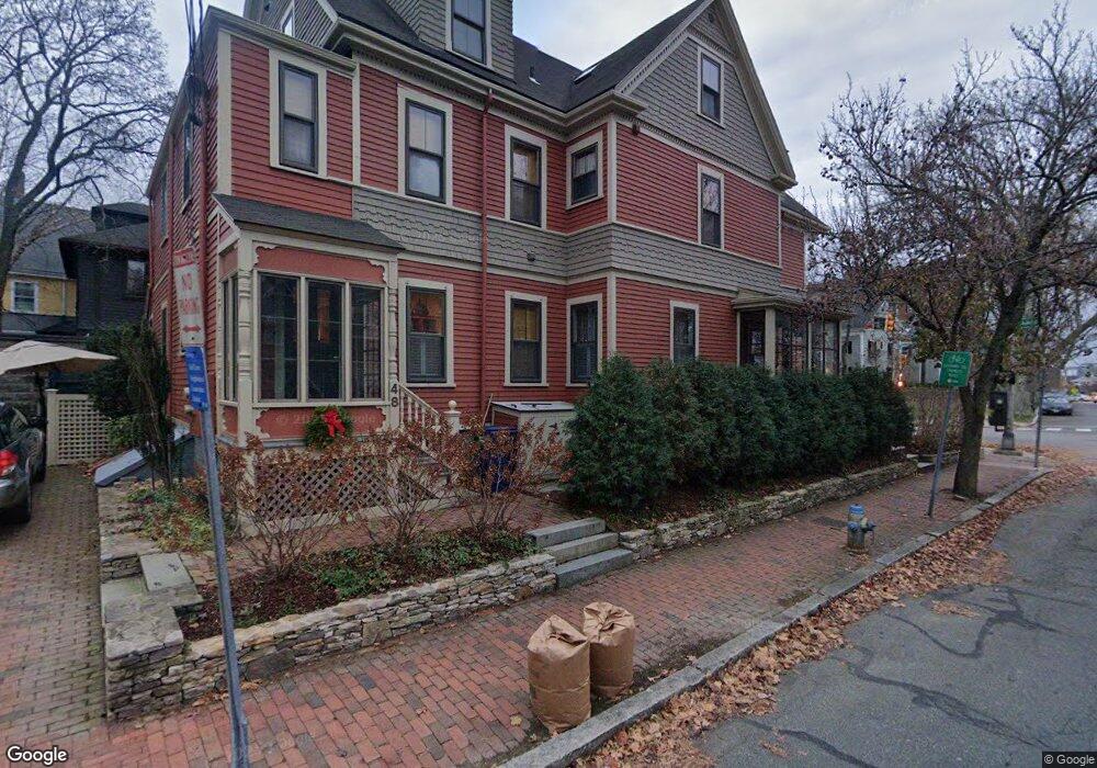
48 Hawthorne St Cambridge, MA 02138
West Cambridge NeighborhoodEstimated Value: $2,297,350 - $3,101,000
3
Beds
3
Baths
2,153
Sq Ft
$1,216/Sq Ft
Est. Value
About This Home
This home is located at 48 Hawthorne St, Cambridge, MA 02138 and is currently estimated at $2,618,783, approximately $1,216 per square foot. 48 Hawthorne St is a home located in Middlesex County with nearby schools including St Peter School, Buckingham Browne & Nichols School, and Cambridge Montessori School.
Ownership History
Date
Name
Owned For
Owner Type
Purchase Details
Closed on
May 18, 2020
Sold by
Mcinnes Donald K
Bought by
Hawthorn Street 48 Rt
Current Estimated Value
Purchase Details
Closed on
Jun 5, 2007
Sold by
Mcinnes Donald K and Mcinnes Jeannette F
Bought by
Mcinnes Donald K
Create a Home Valuation Report for This Property
The Home Valuation Report is an in-depth analysis detailing your home's value as well as a comparison with similar homes in the area
Home Values in the Area
Average Home Value in this Area
Purchase History
| Date | Buyer | Sale Price | Title Company |
|---|---|---|---|
| Hawthorn Street 48 Rt | -- | None Available | |
| Mcinnes Donald K | -- | -- |
Source: Public Records
Tax History Compared to Growth
Tax History
| Year | Tax Paid | Tax Assessment Tax Assessment Total Assessment is a certain percentage of the fair market value that is determined by local assessors to be the total taxable value of land and additions on the property. | Land | Improvement |
|---|---|---|---|---|
| 2025 | $13,009 | $2,048,600 | $0 | $2,048,600 |
| 2024 | $12,053 | $2,035,900 | $0 | $2,035,900 |
| 2023 | $10,947 | $1,868,100 | $0 | $1,868,100 |
| 2022 | $10,725 | $1,811,700 | $0 | $1,811,700 |
| 2021 | $10,216 | $1,746,300 | $0 | $1,746,300 |
| 2020 | $9,374 | $1,630,300 | $0 | $1,630,300 |
| 2019 | $8,990 | $1,513,500 | $0 | $1,513,500 |
| 2018 | $8,762 | $1,393,000 | $0 | $1,393,000 |
| 2017 | $8,671 | $1,336,000 | $0 | $1,336,000 |
| 2016 | $8,689 | $1,243,000 | $0 | $1,243,000 |
| 2015 | $8,636 | $1,104,400 | $0 | $1,104,400 |
| 2014 | $8,536 | $1,018,600 | $0 | $1,018,600 |
Source: Public Records
Map
Nearby Homes
- 32 Hawthorn St
- 5 Brewer St Unit 5
- 988 Memorial Dr Unit 386
- 986 Memorial Dr Unit 404
- 983 Memorial Dr Unit 502
- 984 Memorial Dr Unit 984-503
- 130 Mount Auburn St Unit 108
- 12 Berkeley St
- 3 Berkeley Place
- 975 Memorial Dr Unit 209
- 975 Memorial Dr Unit 211
- 20 Maynard Place
- 22 Concord Ave Unit 10
- 1010 Memorial Dr Unit 6G
- 15 Hubbard Park Rd
- 50 Follen St Unit 505
- 50 Follen St Unit 109
- 44 Garden St
- 48 Hubbard Park Rd
- 52 Garden St Unit B2
- 165 Mount Auburn St Unit 1
- 165 Mount Auburn St
- 165 Mount Auburn St Unit 165
- 42 Hawthorne St
- 40 Hawthorn St Unit 2F
- 40 Hawthorn St Unit 33
- 40 Hawthorn St
- 40 Hawthorn St Unit 1
- 163 Mount Auburn St
- 40 Hawthorne St
- 40 Hawthorne St Unit 1
- 49 Hawthorne St
- 49 Hawthorn St
- 36 Hawthorne St Unit 3
- 36 Hawthorne St Unit 2
- 36 Hawthorne St Unit 1
- 36 Hawthorn St Unit 1
- 36 Hawthorn St Unit 3
- 157 Mount Auburn St
- 157 Mount Auburn St Unit 157