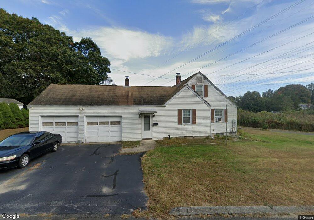
48 Hewitt Dr Uncasville, CT 06382
Oxoboxo River NeighborhoodEstimated Value: $304,000 - $369,000
3
Beds
2
Baths
1,392
Sq Ft
$241/Sq Ft
Est. Value
About This Home
This home is located at 48 Hewitt Dr, Uncasville, CT 06382 and is currently estimated at $335,342, approximately $240 per square foot. 48 Hewitt Dr is a home located in New London County with nearby schools including Leonard J. Tyl Middle School, Montville High School, and Bradley School-New London Regional.
Ownership History
Date
Name
Owned For
Owner Type
Purchase Details
Closed on
Dec 19, 2024
Sold by
Morse Ft and Morse
Bought by
Morton Deeann
Current Estimated Value
Purchase Details
Closed on
Nov 26, 2024
Sold by
Alfiero Richard G
Bought by
Morton Deeann
Purchase Details
Closed on
Jun 28, 2022
Sold by
Morse Theresa A
Bought by
Morse Ft and Morse
Create a Home Valuation Report for This Property
The Home Valuation Report is an in-depth analysis detailing your home's value as well as a comparison with similar homes in the area
Home Values in the Area
Average Home Value in this Area
Purchase History
| Date | Buyer | Sale Price | Title Company |
|---|---|---|---|
| Morton Deeann | -- | None Available | |
| Morton Deeann | -- | None Available | |
| Morton Deeann | -- | None Available | |
| Morton Deeann | -- | None Available | |
| Morse Ft | -- | None Available |
Source: Public Records
Tax History Compared to Growth
Tax History
| Year | Tax Paid | Tax Assessment Tax Assessment Total Assessment is a certain percentage of the fair market value that is determined by local assessors to be the total taxable value of land and additions on the property. | Land | Improvement |
|---|---|---|---|---|
| 2025 | $3,830 | $132,650 | $28,070 | $104,580 |
| 2024 | $3,684 | $132,650 | $28,070 | $104,580 |
| 2023 | $3,684 | $132,650 | $28,070 | $104,580 |
| 2022 | $3,543 | $132,650 | $28,070 | $104,580 |
| 2021 | $3,168 | $99,780 | $27,780 | $72,000 |
| 2020 | $3,231 | $99,780 | $27,780 | $72,000 |
| 2019 | $3,244 | $99,780 | $27,780 | $72,000 |
| 2018 | $3,166 | $99,780 | $27,780 | $72,000 |
| 2017 | $3,163 | $99,780 | $27,780 | $72,000 |
| 2016 | $2,869 | $95,230 | $34,730 | $60,500 |
| 2015 | $2,869 | $95,230 | $34,730 | $60,500 |
| 2014 | $2,797 | $95,230 | $34,730 | $60,500 |
Source: Public Records
Map
Nearby Homes
- 197 Norwich-New London Turnpike
- 36 Depot Rd
- 14 Bluff Rd
- 7 Harvard Rd
- 205 Old Norwich Rd
- 14 Woodland Ln
- 176 Old Norwich Rd
- 19 Wyndwood Rd
- 22 Heather Brook Rd
- 57 Roselund Hill Rd
- 10 Marcia Dr
- 2 Mountain Laurel Ridge
- 5 Mountain Laurel Ridge
- 47 Norman Dr
- 1 High Ridge Cir
- 2 Garden Ct
- 0 Monahan Dr
- 64 Scotch Cap Rd Unit 102
- 270 Gay Hill Rd
- 82 Christy Hill Rd
- 44 Hewitt Dr
- 49 Hewitt Dr
- 16 Hewitt Dr
- 45 Hewitt Dr
- 12 Hewitt Dr
- 31 Hewitt Dr
- 18 Comstock Ave
- 22 Comstock Ave
- 8 Hewitt Dr
- 8 Hewitt Dr Unit A
- 33 Hewitt Dr
- 14 Comstock Ave
- 35 Hewitt Dr
- 61 Norwich New London Turnpike
- 71 Norwich New London Turnpike
- 10 Comstock Ave
- 77 Norwich New London Turnpike
- 11 Comstock Ave
- 7 Power House Rd
- 75 Connecticut 32