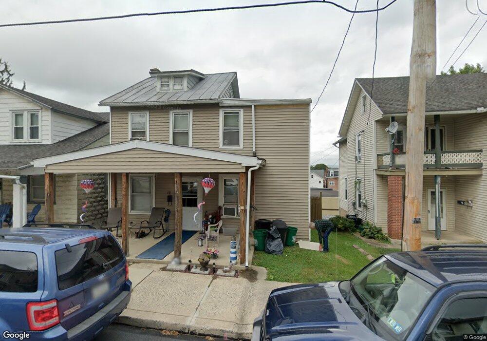
48 Lincoln Ave Ephrata, PA 17522
Estimated Value: $245,109 - $286,000
3
Beds
1
Bath
1,248
Sq Ft
$214/Sq Ft
Est. Value
About This Home
This home is located at 48 Lincoln Ave, Ephrata, PA 17522 and is currently estimated at $267,527, approximately $214 per square foot. 48 Lincoln Ave is a home located in Lancaster County with nearby schools including Highland Elementary School, Ephrata Intermediate School, and Ephrata Senior High School.
Ownership History
Date
Name
Owned For
Owner Type
Purchase Details
Closed on
May 25, 1999
Sold by
Lash Bonnie L and Lash Harold S
Bought by
Fisher Faith F
Current Estimated Value
Home Financials for this Owner
Home Financials are based on the most recent Mortgage that was taken out on this home.
Original Mortgage
$42,109
Interest Rate
11.87%
Create a Home Valuation Report for This Property
The Home Valuation Report is an in-depth analysis detailing your home's value as well as a comparison with similar homes in the area
Home Values in the Area
Average Home Value in this Area
Purchase History
| Date | Buyer | Sale Price | Title Company |
|---|---|---|---|
| Fisher Faith F | $64,900 | -- |
Source: Public Records
Mortgage History
| Date | Status | Borrower | Loan Amount |
|---|---|---|---|
| Previous Owner | Fisher Faith F | $42,109 |
Source: Public Records
Tax History Compared to Growth
Tax History
| Year | Tax Paid | Tax Assessment Tax Assessment Total Assessment is a certain percentage of the fair market value that is determined by local assessors to be the total taxable value of land and additions on the property. | Land | Improvement |
|---|---|---|---|---|
| 2025 | $2,811 | $117,200 | $37,400 | $79,800 |
| 2024 | $2,811 | $117,200 | $37,400 | $79,800 |
| 2023 | $2,741 | $117,200 | $37,400 | $79,800 |
| 2022 | $2,625 | $117,200 | $37,400 | $79,800 |
| 2021 | $2,569 | $117,200 | $37,400 | $79,800 |
| 2020 | $2,569 | $117,200 | $37,400 | $79,800 |
| 2019 | $2,534 | $117,200 | $37,400 | $79,800 |
| 2018 | $3,004 | $117,200 | $37,400 | $79,800 |
| 2017 | $2,493 | $94,200 | $30,400 | $63,800 |
| 2016 | $2,473 | $94,200 | $30,400 | $63,800 |
| 2015 | $547 | $94,200 | $30,400 | $63,800 |
| 2014 | $1,846 | $94,200 | $30,400 | $63,800 |
Source: Public Records
Map
Nearby Homes
- 124 Washington Ave
- 308 Washington Ave
- 323 Lincoln Ave
- 335 Lincoln Ave
- 49 N Church St
- 538 E Main St
- 146 Gregg Cir
- 2 Westpointe Dr
- 11 E Sunset Ave
- 474 N Maple St
- 110 E Pine St
- 18 E Pine St
- 10 E Queen St
- 215 Mason Dr
- 221 Marion Terrace
- 623 N State St
- 210 Marion Terrace
- 114 Brickyard Cir
- 704 Lincoln Ave
- 111 Ridge Ave
- 46 Lincoln Ave
- 50 Lincoln Ave
- 44 Lincoln Ave
- 42 Lincoln Ave
- 54 Lincoln Ave
- 100 Lincoln Ave
- 146 E Locust St
- 40 Lincoln Ave
- 115 Grant St
- 113 Grant St
- 111 Grant St
- 117 Grant St
- 102 Lincoln Ave
- 0 E Hill St Unit 1004568479
- 0 E Hill St Unit 157088
- 0 E Hill St Unit 172048
- 138 E Locust St
- 125 Grant St
- 127 Grant St
- 104 Lincoln Ave