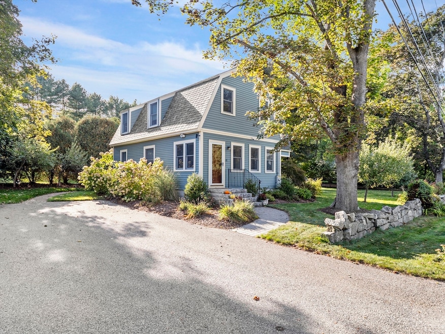

48 Mission Rd Tyngsboro, MA 01879
Estimated payment $3,927/month
Highlights
- Open Floorplan
- Wood Flooring
- Solid Surface Countertops
- Colonial Architecture
- Sun or Florida Room
- No HOA
About This Home
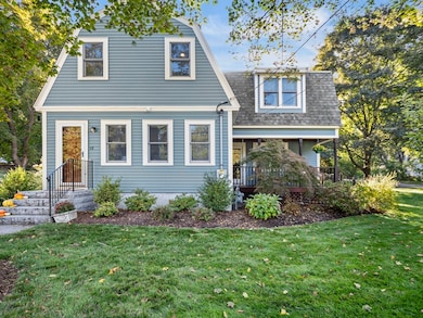
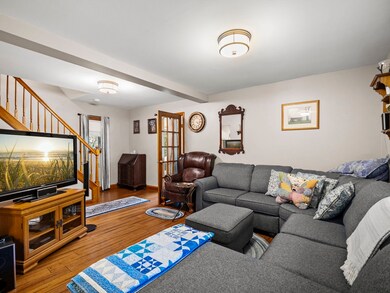
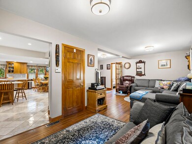
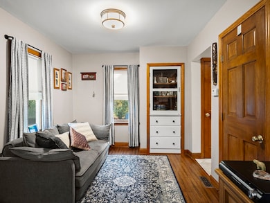
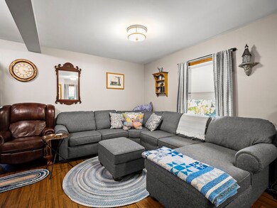
Welcome to 48 Mission Rd, this updated colonial offers a unique blend of historic charm and modern comfort. The sellers did an addition and major renovation in 2000, like buying a 25-year-old house! The focal point on the 1st floor is the spacious tile kitchen with Corian countertops, stainless steel appliances, upgraded cabinets and dining area. Ample space for meal preparation and casual dining, a perfect space for culinary creativity and family get togethers. Dining room open to living room with hardwood floors. Sunroom / office and luxurious tile bath with jacuzzi tub and walk in shower complete the 1st floor. Two comfortable bedrooms and sizable master bedroom with bath and walk in closet. Anderson windows, 200-amp service, gas fired generator, new roof in 2017, central air, town water and sewer, sprinkler system. Mahogany deck overlooking a well landscaped tree lined lot. Excellent location near schools, shopping and commuter routes.
Home Details
Home Type
- Single Family
Est. Annual Taxes
- $5,591
Year Built
- Built in 1901
Lot Details
- 0.26 Acre Lot
- Property is zoned R1
Home Design
- Colonial Architecture
- Frame Construction
- Shingle Roof
Interior Spaces
- 2,065 Sq Ft Home
- Open Floorplan
- Recessed Lighting
- Insulated Windows
- Dining Area
- Sun or Florida Room
- Basement Fills Entire Space Under The House
Kitchen
- Breakfast Bar
- Stove
- Range
- Microwave
- Dishwasher
- Solid Surface Countertops
Flooring
- Wood
- Wall to Wall Carpet
- Ceramic Tile
Bedrooms and Bathrooms
- 3 Bedrooms
- Primary bedroom located on second floor
- Walk-In Closet
- 2 Full Bathrooms
- Soaking Tub
Laundry
- Laundry on main level
- Dryer
- Washer
Parking
- 6 Car Parking Spaces
- Driveway
- Open Parking
- Off-Street Parking
Outdoor Features
- Balcony
- Outdoor Storage
- Porch
Utilities
- Forced Air Heating and Cooling System
- Heating System Uses Natural Gas
- 200+ Amp Service
- Gas Water Heater
Community Details
- No Home Owners Association
Listing and Financial Details
- Assessor Parcel Number M:029 B:0054 L:0,812008
Map
Home Values in the Area
Average Home Value in this Area
Tax History
| Year | Tax Paid | Tax Assessment Tax Assessment Total Assessment is a certain percentage of the fair market value that is determined by local assessors to be the total taxable value of land and additions on the property. | Land | Improvement |
|---|---|---|---|---|
| 2025 | $56 | $453,100 | $171,000 | $282,100 |
| 2024 | $5,232 | $411,300 | $161,900 | $249,400 |
| 2023 | $4,956 | $350,500 | $134,400 | $216,100 |
| 2022 | $4,985 | $333,700 | $117,600 | $216,100 |
| 2021 | $4,914 | $305,800 | $106,900 | $198,900 |
| 2020 | $4,774 | $293,800 | $100,800 | $193,000 |
| 2019 | $27,347 | $259,500 | $96,200 | $163,300 |
| 2018 | $4,387 | $256,400 | $96,200 | $160,200 |
| 2017 | $3,940 | $229,600 | $96,200 | $133,400 |
| 2016 | $3,739 | $212,900 | $96,200 | $116,700 |
| 2015 | $3,792 | $223,600 | $106,900 | $116,700 |
Property History
| Date | Event | Price | List to Sale | Price per Sq Ft |
|---|---|---|---|---|
| 10/14/2025 10/14/25 | Pending | -- | -- | -- |
| 09/25/2025 09/25/25 | For Sale | $659,900 | -- | $320 / Sq Ft |
Purchase History
| Date | Type | Sale Price | Title Company |
|---|---|---|---|
| Quit Claim Deed | -- | None Available | |
| Deed | $73,500 | -- |
Mortgage History
| Date | Status | Loan Amount | Loan Type |
|---|---|---|---|
| Previous Owner | $140,000 | No Value Available | |
| Previous Owner | $37,000 | No Value Available | |
| Previous Owner | $22,000 | No Value Available |
Source: MLS Property Information Network (MLS PIN)
MLS Number: 73435749
APN: TYNG-000029-000054
Disclaimer: Certain information contained herein is derived from information provided by parties other than Homes.com. All information provided is deemed reliable, but is not guaranteed to be accurate and should be independently verified.
![]() The property listing data and information, or the Images, set forth herein were provided to MLS Property Information Network, Inc. from third party sources, including sellers, lessors and public records, and were compiled by MLS Property Information Network, Inc. The property listing data and information, and the Images, are for the personal, non-commercial use of consumers having a good faith interest in purchasing or leasing listed properties of the type displayed to them and may not be used for any purpose other than to identify prospective properties which such consumers may have a good faith interest in purchasing or leasing. MLS Property Information Network, Inc. and its subscribers disclaim any and all representations and warranties as to the accuracy of the property listing data and information, or as to the accuracy of any of the Images, set forth herein.
The property listing data and information, or the Images, set forth herein were provided to MLS Property Information Network, Inc. from third party sources, including sellers, lessors and public records, and were compiled by MLS Property Information Network, Inc. The property listing data and information, and the Images, are for the personal, non-commercial use of consumers having a good faith interest in purchasing or leasing listed properties of the type displayed to them and may not be used for any purpose other than to identify prospective properties which such consumers may have a good faith interest in purchasing or leasing. MLS Property Information Network, Inc. and its subscribers disclaim any and all representations and warranties as to the accuracy of the property listing data and information, or as to the accuracy of any of the Images, set forth herein.
- 10 Worden Rd
- 1 Hope St
- 863 Wellman Ave Unit 863
- 415 Wellman Ave
- 330 Wellman Ave
- 436 Wellman Ave
- 10 Butterfield St
- 271 Wellman Ave
- 251 Wellman Ave Unit 251
- 348 Wellman Ave
- 739 Wellman Ave
- 730 Wellman Ave
- 126 Groton Rd
- 30 Russell Rd
- 20 Merrimac Way Unit 20E
- 16 Middlesex St Unit 4
- 33 Kennedy Dr Unit 33
- 10 Mansur St
- 1461 Pawtucket Blvd Unit 12
- 1401 Pawtucket Blvd Unit 10
