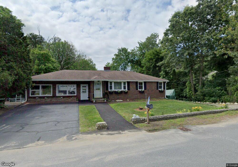
48 Oak Pond Ave Millbury, MA 01527
Estimated Value: $448,000 - $593,000
4
Beds
3
Baths
1,840
Sq Ft
$278/Sq Ft
Est. Value
About This Home
This home is located at 48 Oak Pond Ave, Millbury, MA 01527 and is currently estimated at $510,943, approximately $277 per square foot. 48 Oak Pond Ave is a home located in Worcester County with nearby schools including Elmwood Street Elementary School, Raymond E. Shaw Elementary School, and Millbury Junior/Senior High School.
Ownership History
Date
Name
Owned For
Owner Type
Purchase Details
Closed on
Apr 29, 2015
Sold by
Borci Ret and Richard
Bought by
King Leah M
Current Estimated Value
Home Financials for this Owner
Home Financials are based on the most recent Mortgage that was taken out on this home.
Original Mortgage
$171,830
Outstanding Balance
$132,755
Interest Rate
3.76%
Mortgage Type
FHA
Estimated Equity
$378,188
Create a Home Valuation Report for This Property
The Home Valuation Report is an in-depth analysis detailing your home's value as well as a comparison with similar homes in the area
Home Values in the Area
Average Home Value in this Area
Purchase History
| Date | Buyer | Sale Price | Title Company |
|---|---|---|---|
| King Leah M | $175,000 | -- | |
| King Leah M | $175,000 | -- |
Source: Public Records
Mortgage History
| Date | Status | Borrower | Loan Amount |
|---|---|---|---|
| Open | King Leah M | $171,830 | |
| Closed | King Leah M | $171,830 |
Source: Public Records
Tax History Compared to Growth
Tax History
| Year | Tax Paid | Tax Assessment Tax Assessment Total Assessment is a certain percentage of the fair market value that is determined by local assessors to be the total taxable value of land and additions on the property. | Land | Improvement |
|---|---|---|---|---|
| 2025 | $5,884 | $439,400 | $100,400 | $339,000 |
| 2024 | $5,408 | $408,800 | $93,000 | $315,800 |
| 2023 | $4,880 | $337,700 | $65,300 | $272,400 |
| 2022 | $4,626 | $308,400 | $65,300 | $243,100 |
| 2021 | $4,498 | $291,500 | $65,300 | $226,200 |
| 2020 | $4,381 | $285,800 | $65,300 | $220,500 |
| 2019 | $3,934 | $248,200 | $59,300 | $188,900 |
| 2018 | $3,688 | $225,700 | $59,300 | $166,400 |
| 2017 | $3,243 | $197,400 | $59,300 | $138,100 |
| 2016 | $3,106 | $188,700 | $59,300 | $129,400 |
| 2015 | $3,473 | $211,000 | $63,000 | $148,000 |
| 2014 | $3,553 | $207,800 | $63,000 | $144,800 |
Source: Public Records
Map
Nearby Homes
- 1 Pineland Ave
- 11 Westview Ave
- 12 Irene Ct
- 1 Broadmeadow Ave
- 2 Diane St
- 86 Wheelock Ave
- 3 May St
- 330 Millbury Ave
- 497 Massasoit Rd
- 12 Alstead Path
- 232 Weatherstone Dr
- 76 Weatherstone Dr
- 27 A-B Grafton St
- 3 Stidsen Way
- 90 Macarthur Dr
- 11 Maplewood Rd
- 1203 Grafton St Unit 38
- 1201 Grafton St Unit 73
- 1195 Grafton St Unit 3
- 11 Margin St
- 48 Oak Pond Ave Unit B
- 48A&B Oak Pond Ave
- 50 Oak Pond Ave
- 46 Oak Pond Ave
- 49 Oak Pond Ave
- 47 Oak Pond Ave
- 52 Oak Pond Ave
- 45 Oak Pond Ave
- 53 Oak Pond Ave
- 43 Oak Pond Ave
- 55 Oak Pond Ave
- 42 Oak Pond Ave
- 2 Skyview Dr
- 1 Skyview Dr
- 57-A B Oak Pond Ave
- 57 Oak Pond Ave Unit A
- 1 Skyview Dr
- 41 Oak Pond Ave
- 4 Nightview Place
- 2 Nightview Place