48 Randolph St Portland, ME 04103
Riverton NeighborhoodEstimated payment $3,001/month
Highlights
- Deck
- Wooded Lot
- Wood Flooring
- Contemporary Architecture
- Cathedral Ceiling
- Main Floor Bedroom
About This Home
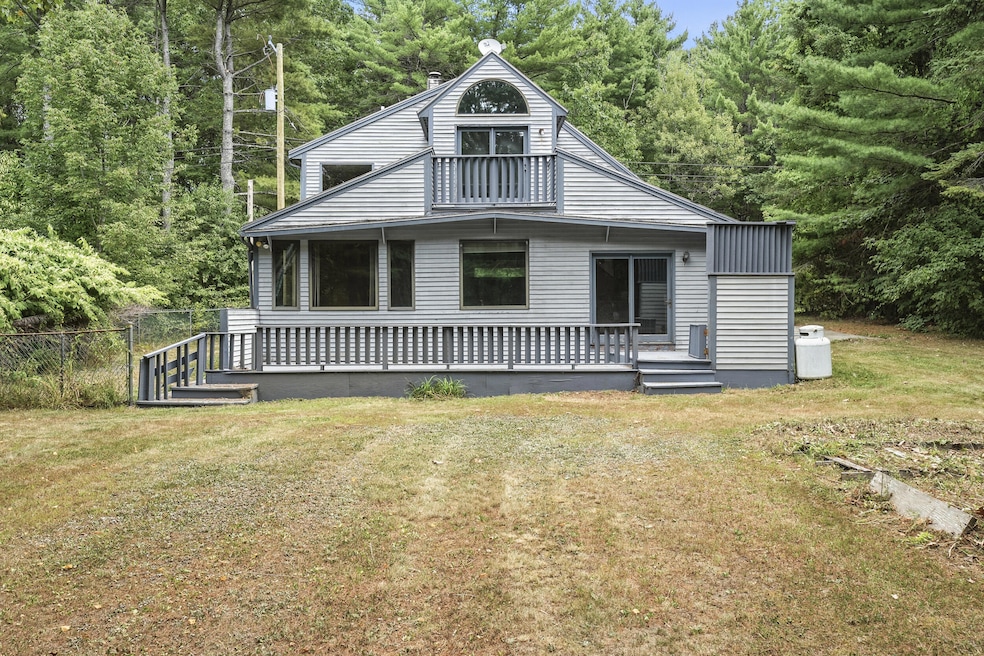
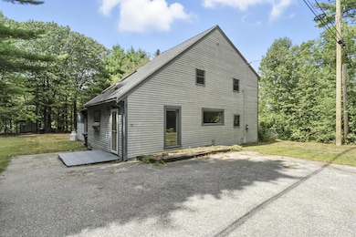
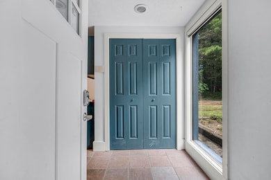
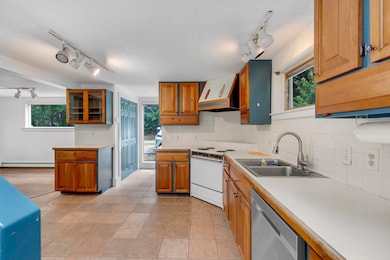
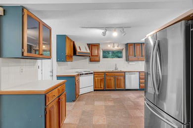
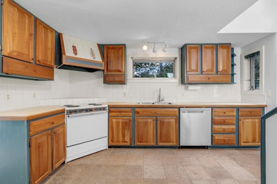
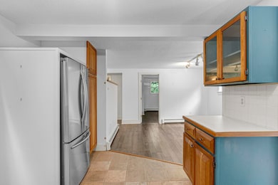
Step into comfort and possibility with this 3-bedroom, 2-bath contemporary-style home. The expansive back living room is a true highlight—spacious enough to serve as both a formal sitting area and a comfortable TV room. With soaring cathedral ceilings, skylights, and a cozy gas fireplace, this inviting space is filled with natural light and opens directly to a large deck and private, tree-lined backyard. At the front of the home, the dining room sits just off the kitchen, creating an easy flow for everyday meals and entertaining. The kitchen features warm cherry cabinetry that brings timeless appeal and room to personalize. A dedicated first-floor office area and a first-floor bedroom add convenience and versatility. Upstairs, two additional bedrooms and a charming balcony nook provide quiet retreats. Recent updates include flooring throughout much of the home and refreshed first-floor paint, offering a solid backdrop for your own style and upgrades. With just a few personal touches, you'll have instant equity and a home tailored to your taste. Located in a quiet neighborhood with Portland Trails diagonally across the street, you'll enjoy year-round outdoor recreation right at your doorstep. All while being just minutes to downtown Portland, local eateries, the Maine Turnpike, the Jetport, and the state's lakes and ocean. Blending privacy, convenience, and potential, this property is ready for its next chapter.
Listing Agent
Megan McShane
Redfin Corporation Listed on: 09/03/2025

Open House Schedule
-
Saturday, November 29, 202511:00 am to 12:30 pm11/29/2025 11:00:00 AM +00:0011/29/2025 12:30:00 PM +00:00Add to Calendar
Home Details
Home Type
- Single Family
Est. Annual Taxes
- $5,918
Year Built
- Built in 1995
Lot Details
- 0.25 Acre Lot
- Landscaped
- Level Lot
- Wooded Lot
Home Design
- Contemporary Architecture
- Wood Frame Construction
- Shingle Roof
- Clapboard
Interior Spaces
- 1,926 Sq Ft Home
- Cathedral Ceiling
- 1 Fireplace
Kitchen
- Electric Range
- Dishwasher
- Disposal
Flooring
- Wood
- Tile
Bedrooms and Bathrooms
- 3 Bedrooms
- Main Floor Bedroom
- Primary bedroom located on second floor
- 2 Full Bathrooms
Laundry
- Dryer
- Washer
Unfinished Basement
- Interior Basement Entry
- Crawl Space
Parking
- Paved Parking
- Off-Street Parking
Outdoor Features
- Deck
- Patio
- Outbuilding
- Porch
Utilities
- No Cooling
- Forced Air Heating System
- Baseboard Heating
- Hot Water Heating System
Community Details
- No Home Owners Association
Listing and Financial Details
- Tax Lot 29
- Assessor Parcel Number PTLD-000335-C000029-000001
Map
Home Values in the Area
Average Home Value in this Area
Tax History
| Year | Tax Paid | Tax Assessment Tax Assessment Total Assessment is a certain percentage of the fair market value that is determined by local assessors to be the total taxable value of land and additions on the property. | Land | Improvement |
|---|---|---|---|---|
| 2024 | $5,918 | $394,300 | $66,300 | $328,000 |
| 2023 | $5,682 | $394,300 | $66,300 | $328,000 |
| 2022 | $5,366 | $394,300 | $66,300 | $328,000 |
| 2021 | $5,122 | $394,300 | $66,300 | $328,000 |
| 2020 | $4,571 | $196,100 | $66,300 | $129,800 |
| 2019 | $4,571 | $196,100 | $66,300 | $129,800 |
| 2018 | $4,408 | $196,100 | $66,300 | $129,800 |
| 2017 | $4,246 | $196,100 | $66,300 | $129,800 |
| 2016 | $4,140 | $196,100 | $66,300 | $129,800 |
| 2015 | $4,046 | $196,100 | $66,300 | $129,800 |
| 2014 | $3,922 | $196,100 | $66,300 | $129,800 |
Property History
| Date | Event | Price | List to Sale | Price per Sq Ft |
|---|---|---|---|---|
| 11/06/2025 11/06/25 | Price Changed | $474,900 | -3.1% | $247 / Sq Ft |
| 10/20/2025 10/20/25 | Price Changed | $489,900 | -2.0% | $254 / Sq Ft |
| 10/01/2025 10/01/25 | Price Changed | $499,900 | -7.4% | $260 / Sq Ft |
| 09/03/2025 09/03/25 | For Sale | $539,900 | -- | $280 / Sq Ft |
Purchase History
| Date | Type | Sale Price | Title Company |
|---|---|---|---|
| Interfamily Deed Transfer | -- | None Available | |
| Interfamily Deed Transfer | -- | None Available |
Mortgage History
| Date | Status | Loan Amount | Loan Type |
|---|---|---|---|
| Closed | $172,500 | New Conventional |
Source: Maine Listings
MLS Number: 1636456
APN: PTLD-000335-000000-C029001
Disclaimer: Certain information contained herein is derived from information provided by parties other than Homes.com. All information provided is deemed reliable, but is not guaranteed to be accurate and should be independently verified.
![]() Listing data is derived in whole or in part from Maine Real Estate Information System, Inc. (d/b/a Maine Listings) and is for consumers' personal, noncommercial use only. Dimensions are approximate and not guaranteed. All data should be independently verified.
Listing data is derived in whole or in part from Maine Real Estate Information System, Inc. (d/b/a Maine Listings) and is for consumers' personal, noncommercial use only. Dimensions are approximate and not guaranteed. All data should be independently verified.
© 2025 Maine Real Estate Information System, Inc. All Rights Reserved. Equal Housing Opportunity.
Homes.com, LLC, 17600 Laguna Canyon Rd Irvine, CA 92618 (888)-952-6393
![]()
- 1619 Washington Ave
- 10 White Birch Ln
- 723 Riverside St
- 240 Harvard St
- 1060 Forest Ave Unit 2
- 147 Pleasant Ave
- 34 Pleasant Ave Unit 34
- 24 Rowe Ave Unit 1
- 46 Saunders St Unit FLOOR 1
- 66 Rowe Ave
- 3 Austrian Way Unit 3 Austrian Way Apt
- 49 Berkshire Rd
- 8 Pine Rd
- 207 Coyle St Unit 4
- 280 Main St Unit 2
- 583 Washington Ave Unit 2
- 41 Winchester Dr
- 509 Forest Ave
- 100 Forest Park
- 14 Emmons St Unit 1