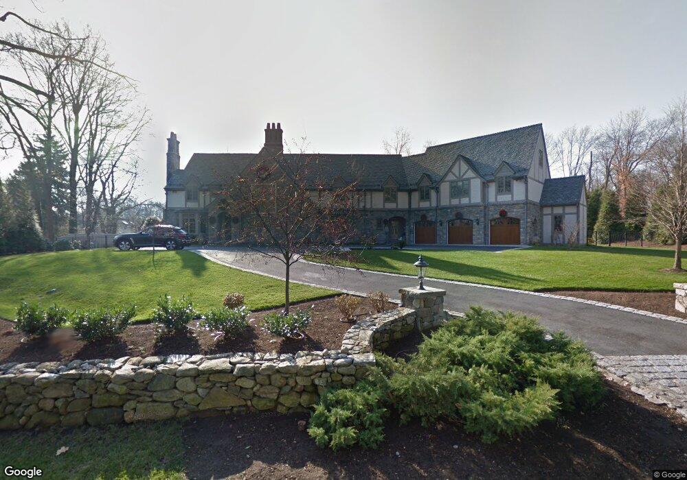
48 Rings End Rd Darien, CT 06820
Estimated Value: $4,662,000 - $6,772,000
4
Beds
7
Baths
9,070
Sq Ft
$620/Sq Ft
Est. Value
About This Home
This home is located at 48 Rings End Rd, Darien, CT 06820 and is currently estimated at $5,623,307, approximately $619 per square foot. 48 Rings End Rd is a home located in Fairfield County with nearby schools including Hindley Elementary School, Middlesex Middle School, and Darien High School.
Ownership History
Date
Name
Owned For
Owner Type
Purchase Details
Closed on
May 10, 2017
Sold by
1958 Post Road Llc
Bought by
1950 Post Road Llc
Current Estimated Value
Purchase Details
Closed on
Sep 30, 2009
Sold by
Orourke Patricia
Bought by
Vaccaro Jon A and Vaccaro Pamela A
Create a Home Valuation Report for This Property
The Home Valuation Report is an in-depth analysis detailing your home's value as well as a comparison with similar homes in the area
Home Values in the Area
Average Home Value in this Area
Purchase History
| Date | Buyer | Sale Price | Title Company |
|---|---|---|---|
| 1950 Post Road Llc | -- | -- | |
| 1958 Post Road Llc | -- | -- | |
| Vaccaro Jon A | $1,115,000 | -- |
Source: Public Records
Tax History
| Year | Tax Paid | Tax Assessment Tax Assessment Total Assessment is a certain percentage of the fair market value that is determined by local assessors to be the total taxable value of land and additions on the property. | Land | Improvement |
|---|---|---|---|---|
| 2025 | $57,452 | $3,711,400 | $959,210 | $2,752,190 |
| 2024 | $54,520 | $3,711,400 | $959,210 | $2,752,190 |
| 2023 | $58,514 | $3,322,760 | $710,500 | $2,612,260 |
| 2022 | $57,251 | $3,322,760 | $710,500 | $2,612,260 |
| 2021 | $9,111 | $3,322,760 | $710,500 | $2,612,260 |
| 2020 | $54,360 | $3,322,760 | $710,500 | $2,612,260 |
| 2019 | $54,726 | $3,322,760 | $710,500 | $2,612,260 |
| 2018 | $7,822 | $3,354,750 | $895,930 | $2,458,820 |
| 2017 | $54,213 | $3,354,750 | $895,930 | $2,458,820 |
| 2016 | $52,904 | $3,354,750 | $895,930 | $2,458,820 |
| 2015 | $51,495 | $3,354,750 | $895,930 | $2,458,820 |
| 2014 | $50,355 | $3,354,750 | $895,930 | $2,458,820 |
Source: Public Records
Map
Nearby Homes
- 18 Pasture Ln
- 20 Outlook Dr
- 23 Beach Dr
- 3 Salt Box Ln E
- 32 Relihan Rd
- 66 Stanton Rd
- 77 Maple St
- 12 Walmsley Rd
- 166 Hollow Tree Ridge Rd
- 167 Hollow Tree Ridge Rd
- 15 Charles St
- 29 Waterbury Ave
- 18 Winding Ln
- 33 Dora St
- 20 Locust Hill Rd
- 7 Dora St Unit 7
- 5 Shields Ln
- 18 Tokeneke Trail
- 10 Cross Rd
- 2 Settlers Trail Unit 2
Your Personal Tour Guide
Ask me questions while you tour the home.