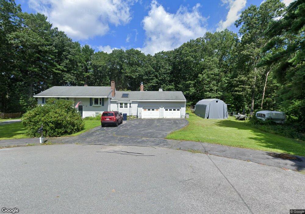
48 Sheridan Rd Marlborough, MA 01752
Estimated Value: $604,507 - $674,000
3
Beds
2
Baths
1,394
Sq Ft
$462/Sq Ft
Est. Value
About This Home
This home is located at 48 Sheridan Rd, Marlborough, MA 01752 and is currently estimated at $643,877, approximately $461 per square foot. 48 Sheridan Rd is a home located in Middlesex County with nearby schools including Marlborough High School, New Covenant Christian School, and Glenhaven Academy - JRI School.
Ownership History
Date
Name
Owned For
Owner Type
Purchase Details
Closed on
Jan 18, 2024
Sold by
Blomquist Paula E and Blomquist Kenneth R
Bought by
Blomquist T T and Blomquist B
Current Estimated Value
Purchase Details
Closed on
Aug 11, 1994
Sold by
Kilgallon Constance A
Bought by
Blomquist Paula E and Blomquist Kenneth R
Home Financials for this Owner
Home Financials are based on the most recent Mortgage that was taken out on this home.
Original Mortgage
$114,000
Interest Rate
8.52%
Mortgage Type
Purchase Money Mortgage
Create a Home Valuation Report for This Property
The Home Valuation Report is an in-depth analysis detailing your home's value as well as a comparison with similar homes in the area
Home Values in the Area
Average Home Value in this Area
Purchase History
| Date | Buyer | Sale Price | Title Company |
|---|---|---|---|
| Blomquist T T | -- | None Available | |
| Blomquist T T | -- | None Available | |
| Blomquist Paula E | $142,500 | -- | |
| Blomquist Paula E | $142,500 | -- |
Source: Public Records
Mortgage History
| Date | Status | Borrower | Loan Amount |
|---|---|---|---|
| Previous Owner | Blomquist Paula E | $115,000 | |
| Previous Owner | Blomquist Paula E | $30,000 | |
| Previous Owner | Blomquist Paula E | $114,000 |
Source: Public Records
Tax History Compared to Growth
Tax History
| Year | Tax Paid | Tax Assessment Tax Assessment Total Assessment is a certain percentage of the fair market value that is determined by local assessors to be the total taxable value of land and additions on the property. | Land | Improvement |
|---|---|---|---|---|
| 2025 | $5,441 | $551,800 | $241,000 | $310,800 |
| 2024 | $5,286 | $516,200 | $219,100 | $297,100 |
| 2023 | $5,488 | $475,600 | $180,000 | $295,600 |
| 2022 | $5,319 | $405,400 | $171,400 | $234,000 |
| 2021 | $10,889 | $370,300 | $142,900 | $227,400 |
| 2020 | $5,015 | $353,700 | $136,100 | $217,600 |
| 2019 | $10,353 | $347,700 | $133,400 | $214,300 |
| 2018 | $15,892 | $339,700 | $116,000 | $223,700 |
| 2017 | $4,974 | $324,700 | $114,200 | $210,500 |
| 2016 | $4,890 | $318,800 | $114,200 | $204,600 |
| 2015 | $4,537 | $287,900 | $122,500 | $165,400 |
Source: Public Records
Map
Nearby Homes
- 114 Linda Cir
- 34 Muir Way
- 688 Boston Post Rd E Unit 202
- 688 Boston Post Rd E Unit 304
- 688 Boston Post Rd E Unit 100
- 688 Boston Post Rd E Unit 324
- 688 Boston Post Rd E Unit 228
- 624 Boston Post Rd E Unit 7
- 608 Boston Post Rd E Unit 11
- 596 Boston Post Rd E Unit 13
- 596 Boston Post Rd E
- 109 Westminster Dr Unit 109
- 38 Collins Dr
- 17 Mcneil Cir
- 23 Victoria Ln
- 271 Boston Post Rd E Unit 4
- 10 Eldorado Dr
- 256 Robert Rd
- 32 Ethel
- 261 Boston Post Rd E Unit 1
- 40 Sheridan Rd
- 30 Sheridan Rd
- 49 Sheridan Rd
- 39 Sheridan Rd
- 275 Hemenway St
- 265 Hemenway St
- 18 Sheridan Rd
- 31 Sheridan Rd
- 285 Hemenway St
- 21 Sheridan Rd
- 297 Hemenway St
- 277 Wilson St
- 277 Wilson St
- 265 Wilson St
- 264 Hemenway St
- 276 Hemenway St
- 307 Hemenway St
- 286 Hemenway St
- 249 Wilson St
- 319 Hemenway St