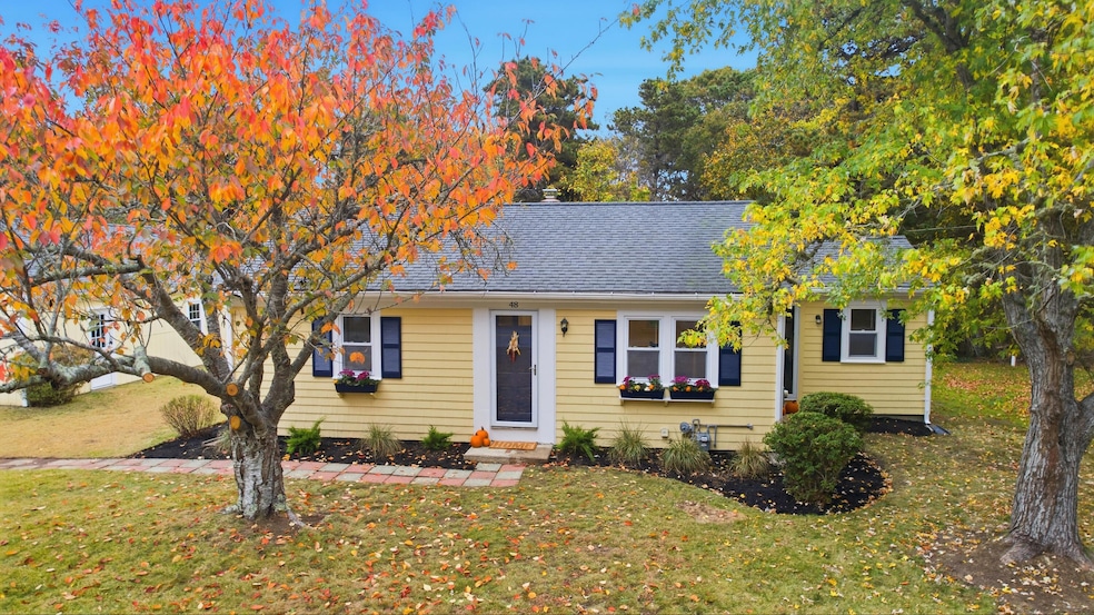
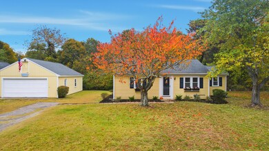
48 Wendward Way West Yarmouth, MA 02673
West Yarmouth NeighborhoodEstimated payment $3,068/month
Highlights
- Property is near a marina
- Wood Flooring
- Outdoor Shower
- Medical Services
- No HOA
- Property is near shops
About This Home
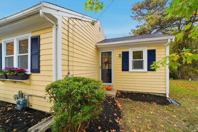
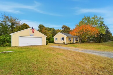
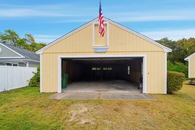
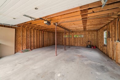
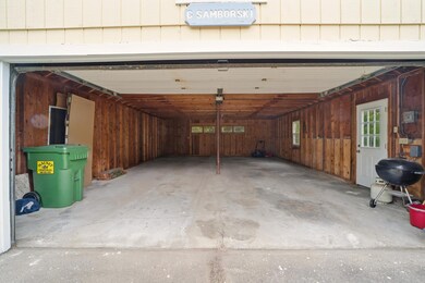
First time on the market in over 50 years is this cute as a button 3 bed one bath ranch close to beaches, golf, coffee shops, sidewalks to downtown Hyannis and the island ferries! Step in to the living/dining combination with hardwood floors, overlooking the updated kitchen with white shaker cabinets, backsplash, countertops, and gas stove. Upgrades include: brand new 3 bedroom septic (7/25) basement staircase (10/25), professionally painted interior/exterior (10/25) re-sanded hardwood floors (10/25). Heat and A/C 2022, newer electric panel, newer windows, blown in insulation/Mass Save. A standout feature is the oversized 2-car garage for vehicles, recreational equipment, beach toys, and attic storage. Beautiful level lot with potential for room to expand. Excellent rental potential or your own little Cape Cod getaway for summer days or year-round living. Wash off the salt in your outdoor shower and head to downtown Hyannis for shopping and dining. This could be you saying, call me when you get to the bridge! Some photos virtually staged.
Listing Agent
William Raveis Real Estate & Home Services License #119613 Listed on: 10/29/2025

Home Details
Home Type
- Single Family
Est. Annual Taxes
- $2,694
Year Built
- Built in 1955 | Remodeled
Lot Details
- 0.35 Acre Lot
- Level Lot
- Property is zoned 1010
Parking
- 2 Car Garage
- Open Parking
Home Design
- Asphalt Roof
- Shingle Siding
- Concrete Perimeter Foundation
Interior Spaces
- 828 Sq Ft Home
- 1-Story Property
Kitchen
- Gas Range
- Microwave
Flooring
- Wood
- Vinyl
Bedrooms and Bathrooms
- 3 Bedrooms
- 1 Full Bathroom
Basement
- Basement Fills Entire Space Under The House
- Interior Basement Entry
Outdoor Features
- Outdoor Shower
- Property is near a marina
Location
- Property is near shops
- Property is near a golf course
Utilities
- Central Air
- Heating Available
- Gas Water Heater
- Septic Tank
Community Details
- No Home Owners Association
- Medical Services
Listing and Financial Details
- Assessor Parcel Number YARM M:0036 B:00119 L:0000
Map
Home Values in the Area
Average Home Value in this Area
Tax History
| Year | Tax Paid | Tax Assessment Tax Assessment Total Assessment is a certain percentage of the fair market value that is determined by local assessors to be the total taxable value of land and additions on the property. | Land | Improvement |
|---|---|---|---|---|
| 2025 | $2,694 | $380,500 | $143,100 | $237,400 |
| 2024 | $2,727 | $369,500 | $150,800 | $218,700 |
| 2023 | $2,669 | $329,100 | $134,400 | $194,700 |
| 2022 | $2,547 | $277,400 | $120,900 | $156,500 |
| 2021 | $2,434 | $254,600 | $120,900 | $133,700 |
| 2020 | $2,408 | $240,800 | $120,800 | $120,000 |
| 2019 | $2,267 | $224,500 | $120,800 | $103,700 |
| 2018 | $2,081 | $202,200 | $98,500 | $103,700 |
| 2017 | $1,995 | $199,100 | $98,500 | $100,600 |
| 2016 | $1,897 | $190,100 | $89,500 | $100,600 |
| 2015 | $1,794 | $178,700 | $89,500 | $89,200 |
Property History
| Date | Event | Price | List to Sale | Price per Sq Ft |
|---|---|---|---|---|
| 11/01/2025 11/01/25 | Pending | -- | -- | -- |
| 10/29/2025 10/29/25 | For Sale | $540,000 | -- | $652 / Sq Ft |
Purchase History
| Date | Type | Sale Price | Title Company |
|---|---|---|---|
| Quit Claim Deed | -- | -- | |
| Quit Claim Deed | -- | -- | |
| Quit Claim Deed | -- | -- | |
| Quit Claim Deed | -- | -- | |
| Quit Claim Deed | -- | None Available | |
| Deed | $50,000 | -- | |
| Deed | $50,000 | -- |
Mortgage History
| Date | Status | Loan Amount | Loan Type |
|---|---|---|---|
| Previous Owner | $119,000 | Adjustable Rate Mortgage/ARM | |
| Previous Owner | $60,000 | Purchase Money Mortgage |
Source: Cape Cod & Islands Association of REALTORS®
MLS Number: 22505417
APN: YARM-000036-000119
Disclaimer: Certain information contained herein is derived from information provided by parties other than Homes.com. All information provided is deemed reliable, but is not guaranteed to be accurate and should be independently verified.
![]() All data relating to real estate for sale on this page comes from the Broker Reciprocity (BR) of the Cape Cod & Islands Multiple Listing Service, Inc. Detailed information about real estate listings held by brokerage firms other than CC&I Assoc. of REALTORS®, Inc. includes the name of the listing company. Neither the listing company nor CC&I Assoc. of REALTORS®, Inc. shall be responsible for any typographical errors, misinformation, misprints and shall be held totally harmless. The Broker providing this data believes it to be correct, but advises interested parties to confirm any item before relying on it in a purchase decision. All properties are subject to prior sale, changes, or withdrawal. Copyright 2025 © Cape Cod & Islands Multiple Listing Service, Inc. All rights reserved.
All data relating to real estate for sale on this page comes from the Broker Reciprocity (BR) of the Cape Cod & Islands Multiple Listing Service, Inc. Detailed information about real estate listings held by brokerage firms other than CC&I Assoc. of REALTORS®, Inc. includes the name of the listing company. Neither the listing company nor CC&I Assoc. of REALTORS®, Inc. shall be responsible for any typographical errors, misinformation, misprints and shall be held totally harmless. The Broker providing this data believes it to be correct, but advises interested parties to confirm any item before relying on it in a purchase decision. All properties are subject to prior sale, changes, or withdrawal. Copyright 2025 © Cape Cod & Islands Multiple Listing Service, Inc. All rights reserved.
- 23 Baxter Ave
- 60 Baxter Ave
- 73 Baxter Ave
- 16 Iyannough Rd
- 10 Trenton St
- 0 Ken's Way
- 83 Main St
- 22 Terry Ct
- 14 Brewster Rd
- 110 School St Unit E114
- 110 School St Unit E209
- 110 School St Unit E101
- 15 Webster Rd
- 481 Buck Island Rd Unit 17FA
- 481 Buck Island Rd Unit 9AA
- 115 School St Unit W206
- 18 Rachel Rd
- 15 Mayflower Rd
- 35 Pleasant St
- 12 Denver Dr