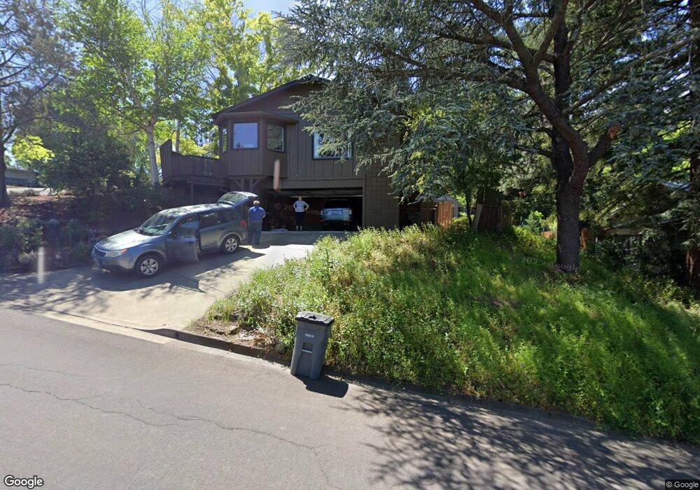
480 Ashland St Ashland, OR 97520
Estimated Value: $702,000 - $851,000
4
Beds
3
Baths
2,116
Sq Ft
$370/Sq Ft
Est. Value
About This Home
This home is located at 480 Ashland St, Ashland, OR 97520 and is currently estimated at $781,915, approximately $369 per square foot. 480 Ashland St is a home located in Jackson County with nearby schools including Walker Elementary School, Ashland Middle School, and Ashland High School.
Ownership History
Date
Name
Owned For
Owner Type
Purchase Details
Closed on
Apr 9, 2018
Sold by
Smith Alford Robert and Smith Lucretia
Bought by
Vita Charles A and Puga Anna Balboa
Current Estimated Value
Home Financials for this Owner
Home Financials are based on the most recent Mortgage that was taken out on this home.
Original Mortgage
$472,960
Interest Rate
4.37%
Mortgage Type
Adjustable Rate Mortgage/ARM
Create a Home Valuation Report for This Property
The Home Valuation Report is an in-depth analysis detailing your home's value as well as a comparison with similar homes in the area
Home Values in the Area
Average Home Value in this Area
Purchase History
| Date | Buyer | Sale Price | Title Company |
|---|---|---|---|
| Vita Charles A | $591,200 | First American Title |
Source: Public Records
Mortgage History
| Date | Status | Borrower | Loan Amount |
|---|---|---|---|
| Previous Owner | Vita Charles A | $472,960 |
Source: Public Records
Tax History Compared to Growth
Tax History
| Year | Tax Paid | Tax Assessment Tax Assessment Total Assessment is a certain percentage of the fair market value that is determined by local assessors to be the total taxable value of land and additions on the property. | Land | Improvement |
|---|---|---|---|---|
| 2025 | $5,240 | $432,721 | $141,401 | $291,320 |
| 2024 | $5,240 | $420,120 | $137,270 | $282,850 |
| 2023 | $5,539 | $405,229 | $130,609 | $274,620 |
| 2022 | $5,219 | $405,229 | $130,609 | $274,620 |
| 2021 | $5,136 | $393,432 | $126,812 | $266,620 |
| 2020 | $4,990 | $381,974 | $123,124 | $258,850 |
| 2019 | $4,878 | $360,061 | $116,051 | $244,010 |
| 2018 | $3,720 | $300,225 | $108,605 | $191,620 |
| 2017 | $3,690 | $300,225 | $108,605 | $191,620 |
| 2016 | $3,509 | $283,004 | $102,364 | $180,640 |
| 2015 | $3,491 | $283,004 | $102,364 | $180,640 |
| 2014 | $3,147 | $256,796 | $134,736 | $122,060 |
Source: Public Records
Map
Nearby Homes
- 500 Mt Ashland Ski Rd
- 9840 Mount Ashland Ski Rd
- 0 Colestin Rd Unit 104385842
- 4712 Old Highway 99 S
- 0 Old Hwy 99 Unit 220199869
- 5010 Old Highway 99 S
- 5631 Old Highway 99 S
- 4492 Old Highway 99 S
- 1988 Old Siskiyou Hwy
- 1694 Old Siskiyou Hwy
- 0 Highway 99 Unit 220209869
- 500 Conifer Way
- 3721 Old Highway 99 S
- 545 Conifer Way
- 492 Conifer Way
- 899 Timberlake Dr
- 700 Neil Creek Rd
- 4260 Clayton Rd
- 0 Timberlake Dr Unit 391E25 132 220208170
- 694 Timberlake Dr