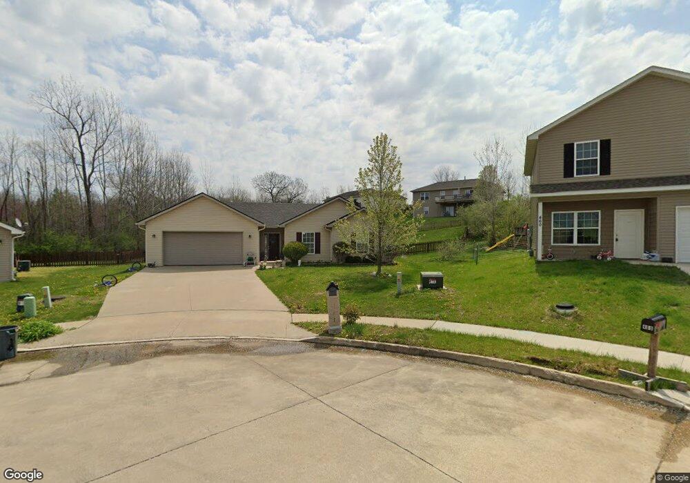
480 E Cedar Ct Columbia, MO 65202
Estimated Value: $227,000 - $251,000
3
Beds
2
Baths
1,354
Sq Ft
$179/Sq Ft
Est. Value
About This Home
This home is located at 480 E Cedar Ct, Columbia, MO 65202 and is currently estimated at $242,585, approximately $179 per square foot. 480 E Cedar Ct is a home located in Boone County with nearby schools including Parkade Elementary School, Smithton Middle School, and David H. Hickman High School.
Ownership History
Date
Name
Owned For
Owner Type
Purchase Details
Closed on
May 18, 2009
Sold by
Double D Development Inc
Bought by
Ivicsics Antoinette T
Current Estimated Value
Home Financials for this Owner
Home Financials are based on the most recent Mortgage that was taken out on this home.
Original Mortgage
$132,500
Outstanding Balance
$90,705
Interest Rate
4.62%
Mortgage Type
USDA
Estimated Equity
$151,880
Create a Home Valuation Report for This Property
The Home Valuation Report is an in-depth analysis detailing your home's value as well as a comparison with similar homes in the area
Purchase History
| Date | Buyer | Sale Price | Title Company |
|---|---|---|---|
| Ivicsics Antoinette T | -- | None Available |
Source: Public Records
Mortgage History
| Date | Status | Borrower | Loan Amount |
|---|---|---|---|
| Open | Ivicsics Antoinette T | $132,500 |
Source: Public Records
Tax History
| Year | Tax Paid | Tax Assessment Tax Assessment Total Assessment is a certain percentage of the fair market value that is determined by local assessors to be the total taxable value of land and additions on the property. | Land | Improvement |
|---|---|---|---|---|
| 2025 | $2,195 | $31,217 | $3,325 | $27,892 |
| 2024 | $2,053 | $28,386 | $3,325 | $25,061 |
| 2023 | $2,035 | $28,386 | $3,325 | $25,061 |
| 2022 | $1,956 | $27,303 | $3,325 | $23,978 |
| 2021 | $1,959 | $27,303 | $3,325 | $23,978 |
| 2020 | $1,922 | $25,281 | $3,325 | $21,956 |
| 2019 | $1,922 | $25,281 | $3,325 | $21,956 |
| 2018 | $1,791 | $0 | $0 | $0 |
| 2017 | $1,770 | $23,408 | $3,325 | $20,083 |
| 2016 | $1,768 | $23,408 | $3,325 | $20,083 |
| 2015 | $1,632 | $23,408 | $3,325 | $20,083 |
| 2014 | -- | $23,408 | $3,325 | $20,083 |
Source: Public Records
Map
Nearby Homes
- 5335 N Rocky Fork Dr
- L401-L430 Forest Ridge Plat 4
- 0 N Highway Vv
- 5304 Aspen Ridge Dr
- 5280 N Burning Bush Rd
- 154 E Tully Ct
- 5281 N Burning Bush Rd
- LOT 22 Lookout Peak Dr
- 5041 N Jasmine Way
- L22 Lookout Peak Dr
- L23 Lookout Peak Dr
- LOT 18 Lookout Peak Dr
- LOT 70 Aspen Ridge Dr
- 6131 N Wagon Trail Rd
- 4980 N Irvin Loop
- 6445 N Wagon Trail Rd
- 1367 E Wagon Trail Heights
- LOT 502 Sullivan St
- 5171 N Creasy Springs Rd
- LOT 143 Sullivan St
- 460 E Cedar Ct
- 460 E East Cedar Ct
- 490 E Cedar Ct Unit E
- 490 E East Cedar Ct
- 5711 N Hilary Ct
- 5681 N Hilary Ct
- 5681 Hillary Ct
- 5711 Hillary Ct
- 5730 Tyler Dr
- 5665 N Hilary Ct
- 5750 Tyler Dr
- 5665 E Hilary Ct
- 5710 N Tyler
- 5710 Tyler Dr
- 5700 Hillary Ct
- 5700 N Hilary Ct
- 5680 Tyler Dr
- 441 E Cedar Ct
- 5660 Tyler Dr
Your Personal Tour Guide
Ask me questions while you tour the home.